Friday, September 22, 2017

9/22/17 Report - Predicting Versus Rating Beach Conditions. Will Maria Send Us Good Hunting? Coaked Sheave. Beached Sailboat.


Written by the TreasureGuide for the exclusive use of treasurebeachesreport.blogspot.com.

Washed Up.
Photo by Warren D.
Warren D. said, This is located in Brevard County at South Spessard Holland Park. Similar to the one in Vero a couple of years ago.

I talked with the Channel 13 reporters and they said no one was on board but there was a mannequin.

The coast guard had boarded it at sea and saw no one was on board and they painted "OK" on the hull.
---

Two hurricanes and little to show for it.  Disappointing!  That is how you might be feeling.

Irma and Jose raised expectations but didn't deliver much.  The surf got bigger, but on the Treasure Coast we didn't get anymore than brief erosion at a few spots.  There were definitely places that got more.

As I said the other day, it isn't over yet.  We still have a chance.  Maria is still out there, and they are predicting a surf of six to nine feet for three days.  And Monday we're supposed to have North winds. That could be what we've been waiting for.

I recently highlighted some factors that have to come together to produce what I would call ideal beach hunting conditions when I referred to the legendary Thanksgiving Storm: high surf, north/northeast wind, continuing for days coordinated with high tides.

The MagicSeaWeed surf predictions are frequently off when they predict a very high surf several days in advance.  As I've often pointed out, those high predicted surfs tend to get smaller as the time gets closer.  I don't know why that is, but it is a definite error in their model.

It is often said that one of the most important qualities for a treasure hunter is patience.  Treasure hunting is a very opportunistic activity.  You have to be at the right place at the right time.  You have to be alert and prepared to take advantage when the window of opportunity opens.

I often say there is always some place good to detect.  You might have to adapt.  It depends upon what you are willing and able to do.

I have no doubt that some of the most serious detectorists will travel to other parts of the state to find better hunting conditions.  Over the years I ran into fellows that lived in their van and traveled around always looking for  the best location they could find to detect.  Maybe they'd pull into Fort Lauderdale during the height of spring break, park their van and detect for days until some better opportunity called, and then they'd move on.  They'd follow the opportunities.

Most of us aren't willing to live out of a van and follow the biggest and best detecting opportunities. That is a choice we make.  For me and you that might be a good choice, but it is a choice.  We have our priorities and detecting doesn't come first.

You might have been disappointed by Irma and Jose.  It is better to be prepared than not be prepared when the window of opportunity does open.

I don't think I've issued any higher than a three rating on my Treasure Coast Treasure Beach Detecting Conditions Scale in a few years.  We just haven't had very good beach detecting conditions overall for quite a while.  All of the beach renourishment has not helped.  But there will be a time when the window of opportunity opens wide again, and I'd rather be prepared, even if it means that I was prepared several times and nothing much happened.  I guess it is something like putting up your hurricane shutters.  All of the preparation might be for nothing, but then again, at least you will be prepared when you really need it.

If you wait for me to issue a high rating on my beach conditions scale, I don't do that until I am highly confident that I should.  I don't issue those ratings without making very sure that I am correct.That means that I don't do that early.  I have to see it for myself.  But I also keep you informed about the predictions and developments as they occur, so if you keep up with what I am posting, you should have a very good idea in advance when something good might happen before it happens.

---

Coaked Sheave.
Source: promare.co.uk/ships/finds
Recently I posted photos of sheaves.  One was found on the Treasure Coast as the result of Irma.  Of course sheaves vary.  The one shown above is in very good condition.  The found ones that I showed in this blog don't have the metal bearings anymore.  You can see how the bearing sits into a depression in the wood.

In case you didn't know, a sheave is a wheel used in a pulley block.  Back years ago Ian A. found one on the Treasure Coast with the bearing still in it and marked with a broad arrow, if I correctly recall, indicating it was from a ship of the Royal Navy

---

Source: MagicSeaWeed.com
Notice that the surf predictions slipped just a little but not much.  I hope it doesn't slip any more.

If I had more accurate surf and wind predictions, I'd be able to better predict beach conditions myself.

Happy hunting,
TreasureGuide@comcast.net

Thursday, September 21, 2017

9/21/17 Report - St. Augustine Beaches Hit Hard by Irma. More T. C. Beaches. Couple of Finds. Big Surf This Weekend.


Written by the TreasureGuide for the exclusive use of treasurebeachesreport.blogspot.com.

St. Augustine Area
Photo submitted by Darrel S.

North of St. Augustine Inlet
Photo submitted by Darrel S.


North of St. Augustine Inlet
Photo submitted by Darrel S.
The other day I mentioned that some of the other areas of Florida would probably produce as good or better Irma finds than the Treasure Coast.   Here is a good example of where that could happen.

Darrel S. sent these pictures showing the St. Augustine area.  I can pretty much guarantee that some interesting finds have been or will be made up there.

Thanks for the photos Darrel.

Bon Steel Beach Yesterday
Photo by Joe D.
You might also remember the dugout canoe found in the Cocoa area after Irma.

Below are some new Treasure Coast pictures from Joe D.

Just South of Sebastian Inlet Yesterday
Photo by Joe D.

In Front of Wabasso Disney Resort 
Photo by Joe D.
---

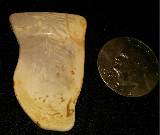
Here is a picture of an item found in England.  It looks similar to the rounded piece of wood found after Irma on the Treasure Coast.  See my 9/15/17 post.

Found Sheave (?)
Photo submitted by William G.
I think this item as well as the one I posted on 9/15 might be an old sheave.  In that case I would suspect that it is made of lignum vitae wood.  Lignum vitae is a very hard wood often used for things like that.  The depression might have held a metal plate.  I think that would make it what would be called a "coaked sheave."

If I'm wrong on that, please correct me.

---

Here is an old Corrigan's find.

Unidentified Corrigan's Find
Photo by Michael S.
It appears to be a piece of oriental ceramics.  If anyone can add to that, please email me.

---

I'm watching the surf predictions for this weekend and next week.

Surf Predcitions
Source: MagicSeaWeed

Ther are now predicting a peak surf of up to nine feet for Sunday and Monday.  It looks like the wind will be most favorable a bit later - maybe Tuesday and Wednesday.

Happy hunting,
TreasureGuide

Wednesday, September 20, 2017

9/20/17 Report - Storms, Hurricanes, Predictions and What To Watch For. Thanksgiving Storm of 1984. Walking Sea Shells. Big Surf Predicted.


Written by the TreasureGuide for the exclusive use of treasurebeachesreport.blogspot.com.

If you only read to see when something has been found, you will sometimes be a little late.  But if you read this blog on a daily basis, you should seldom be caught off-guard.  I spend a lot of time watching developments and predictions and tell you when things might happen before they actually do.  Of course the predicting game isn't perfect.  The meteoroligists are often wrong.   Just look at how Irma developed.  They didn't know where it was going to go until the last few days when the predictions finally firmed up.  It isn't easy.  And it is often wrong.  Yet you should be prepared and ready as well as possible if you keep watching.

I am watching Maria very closely.  She isn't expected to make landfall in Florida, but that is not the important thing when it comes to metal detecting.  Some of the most legendary treasure detecting occurred when there was no hurricane at all.  It only takes a storm that sits off the coast and churns waves for days.

I've gone over this before, but it is a good time to go over it again.  You might be wondering what it is going to take.  We just had a hurricane go right up through the state, and still it didn't do a whole lot for the Treasure Coast. The best illustration I know of is the Thanksgiving Storm of 1984, which is legendary in Treasure Coast treasure lore.

The following data presented in a NOAA publication with the title The Florida East Coast Thanksgiving Holiday Storm of 1984 by Raymond Biedinger, Clifford Brock, Federico Gonzales, and Burt Sylvern.

I'll present some of the NOAA report below and point out by bolding and underlining some of the statements that I think are most noteworthy. Here goes.

Another factor was that these strong onshore winds continued for many days. Winds of near gale force (about 40 miles an hour) began blowing along the north Florida coast the evening of the 20th. They did not subside until late on the 24th. Therefore, much of Florida experienced strong onshore winds for about 4 whole days. These winds were frequently between 30 and 40 miles an hour. The direction of the winds was from the north northeast which is probably the best angle of incidence for beach erosion along the coast from Fernandina Beach to Palm Beach. The coastline south of Palm Beach was spared from most of the adverse effects of the storm because the wind was actually blowing offshore throughout much of the storm. However, this northwest wind caused significant damage to the coastlines of the western Bahama Islands Friday and Saturday. This was all due to the position of the storm center remaining over Grand Bahama Island from early Thursday morning through early Saturday...


As noted earlier, the time of the month that the storm occurred was coincident with the highest astronomical tides of the month and nearly the highest spring tide of the year. Tide tables indicated that the highest predicted tides for the month of November fell on the mornings of the 22nd and the 23rd, exactly during the time of the highest storm tide. Reports from the storm survey teams of the Florida Department of Natural Resources indicate that the storm tide was over 6 feet above low mean water. Tide gauge readings at Mayport were 7.5 feet above mean low water or 5.2 feet above mean sea level. The one factor of the storm episode which magnified the entire situation was the nearly stationary nature of the storm for 3 days. This lack of movement produced the prolonged onshore winds which resulted in at least 4 days of heavy surf pounding the shore. Portions of the coastline experienced 9 high tides during this period, with each succeeding high tide higher than the previous one, thus making the erosion of sand greater with each tide. These are the reasons for the extensive damage that resulted from this particular storm....


...The meteorological conditions just described produced one of the most damaging storms to affect the eastern coastal sections of Florida during the past several decades. Much of the damage from Fernandina Beach southward to North Miami Beach, nearly 400 miles, was caused by the easterly winds of gale force with gusts as high as 60 miles an hour blowing for nearly four days. This action of the wind over the ocean produced shoreward moving swells of around 20 feet which pounded the Florida east coast and produced the most severe beach erosion in recent years in many areas. An example of the destruction was the reduction of the newly completed l100 foot pier at St. Augustine to 300 feet. Sand dunes were obliterated leaving barrier islands void of any natural protection against the next onslaught of a coastal storm in the future. To add to the destructiveness, the highest monthly astronomical tide period coincided with the highest period of storm tides which occurred on the morning of Thursday and Friday, the 22nd and 23rd. All of this produced tides 4 to 6 feet above mean yea level (MSL} at times of high tide. In some places, this was the highest tide in the last 30 years. Alt Mayport, Florida, just north of Jacksonville, the tide of 5.2 feet above MSL was the third highest tide of record. Much of state road A1A, the famous coastal highway, was closed in Indian River County between Vero Beach and Sebastian Inlet because of high water. In this area several beach front buildings collapsed, and 600 to 1,000 people were ordered to evacuate their homes. In Palm Beach County, five blocks of A1A were seriously damaged by the high tides and heavy surf. Bridges were closed because of flooded approaches which caused some barrier islands including the large Hutchinson Island to become isolated for periods of time around the time of high tide. In the storm's aftermath, severe coastal beach erosion stretched from Jacksonville to Palm Beach. ...

 At the West Palm Beach weather office, a new station rainfall record was set on Thanksgiving Day for the greatest amount in a calendar day, 7.41 inches....

There were high winds that blew for three or four days and we were having high tides at the same time.  That is in strong contrast to Irma.

Here is the link to the entire report. http://www.srh.noaa.gov/images/mlb/pdfs/Nov_1984_storm.pdf
---

Yesterday Joe D.told me, Bonsteel to past Rio Mar, all sanded in still!!

Darrel S. said, 

State Park announced 33 parks are still closed. I assume the ones inland more then the coastline, unless Keys or First Coast.

Most of the beaches near St. Augustine were telling people not to walk on the beaches until further notice. I know that area really got slammed!

I have not heard from any dectorists, so cannot give any info on finds or if they are able to detect.

I would bet inland areas where trees are uprooted would be good searching. Especially, around old towns, water holes, etc.

Bet some good bottles and arrowheads could be found.


Under more normal circumstances I would have talked more about some of the other areas around the state.  One person asked about shipwrecks in the Naples area, for example.  Treasure cons are found over there.  That is about all I had time to tell him at the time.

There are certainly other areas that will be producing treasure - perhaps more than the Treasure Coast right now.  The Treasure Coast is now pretty much sanded in.

Thanks to Joe and Darrel for submitted their observations.  I hadn't been up to Bonsteel and wondered about that.

---

There are now some beautiful shells on some of the beaches, including Frederick Douglas beach. Some are big and colorful. When you pick up one of those shells, please check to see if it is inhabited by a crab or some other creature. Many of the nicest will be inhabited. The inhabitant might be very difficult to see. When you pick up an inhabited shell, the creature will withdraw into the shell as deeply as they can. It might be very difficult to see. If you mistakenly take a pretty shell home believing it to be abandoned when it is not, you'll notice a strong smell when the creature dies.

Hermit Crab In Seashell.
Source: Wikipedia
That subject always reminds me of the time on Key Biscayne when I saw a hermit crab using a broken bottle neck with the bottle cap still in place as a  mobile home.  I always wish I had a photo of that.

---

Below is what I'm watching now.  MagicSeaWeed is predicting up to a 13 foot surf for Sunday.  I wouldn't be surprised if it turns out to be smaller, but that isn't the only factor.  We'll have to watch the wind direction and tides too.

Source: MagicSeaWeed.com
Some detecting opportunities are short-lived - lasting only a matter of hours, while others last days or more.

Happy hunting,
TreasureGuide@comcast.net

Tuesday, September 19, 2017

9/19/17 Report - It Isn't Over Yet. Maria Might Bring 14 Foot Surf. Beaches Around The Treasure Coast.


Written by the TreasureGuide for the exclusive use of treasurebeachesreport.blogspot.com

Source: MagicSeaWeed.com.
Yesterday I wrote, "Its only just begun."  You might have wondered why.  The above is a big part of it.  A 10 - 14 foot surf is predicted for the Fort Pierce area next Monday.  

As you know, it takes more than a big surf, although if the surf is big enough, that can by itself can do a lot.  The direction of the surf also has a lot to do with beach conditions.  That is what has been missing most so far.  While we did get some brief periods of north wind and swells, it wasn't sustained, and most of the time the water was hitting the beach straight on. 

I've commented often about the short-comings of the long range surf predictions that MagicSeaWeed puts out.  Very often a big surf predicted several days in advance never happens.  We can only wait and see.

---

Ambersands Looking South.
Photo by Joe D.
Neither Irma nor Jose did a lot to improve metal detecting conditions on the Treasure Coast.  They did some good, but not a lot.

As you've seen, some things were found.  There were very few reports of treasure coins so far though.

Some beaches remain closed.  You can only guess why.

We didn't get anything sustained for any length of time and nothing really huge.  Another thing is all of the renourishment sand.  You can see that in the first photo above.  Nothing but renourishment sand.

Joe D. sent these photos with the following report.

... I too was hoping for a better wave angle to remove more sand! Instead I trudged through about 4 miles of mushy sand with nothing but a very small amount of trash to show for it! But it was still nice to get out here again!

 I started at Amber Sands, but did not hunt there due to poor conditions, and talking to another detectorist who was leaving and got skunked in his hunt! Decided to go to Rio Mar and try my luck
before tide fully came in! Went North first; which was more of the same mushy sand for over a mile that I detected! Returned South and did not hit good hard beach with shells and rocks exposed until a good distance past golf course! But by then the tide was almost at its high mark, so I ended my day there! ...

Rio Mar Looking North
Photo by Joe D.

Rio Mar Looking South
Photo by Joe D.
Thanks for the photos and report Joe.


John Brooks Yesterday
 I took these photos of John Brooks and Frederick Douglas yesterday.

Frederick Douglas Yesterday.
 John Brooks was mostly mushy - slightly firmer near the water.

Frederick Douglas had more features.  There were shells and some dips between the sand bar and the front beach.

You can see the shells.  There were light targets on the front beach by the water and in the shells.  Mostly aluminum.

St. Lucie Parks says that Walton Rocks remains closed indefinitely because of debris that needs to be cleared.

Irma produced some very interesting finds, but I don't know of many treasure coins.  Jose didn't do as much as I was expecting, but we still might get the big surf that is expected to come from Maria.  It isn't over yet.

Happy hunting,
TreasureGuide@comcast.net

Monday, September 18, 2017

9/18/17 - Hurricane Irma Uncovered Great Find. Parts of Unidentified Shipwreck Uncovered Too. Its Only Just Begun.


Written by the TreasureGuide for the exclusive use of treasurebeachesreport.blogspot.com.

PHOTO: Randy Lathrop of Cocoa, Fla., discovered the historic dugout canoe, Sept. 11, 2017, after Irma struck the coast. (Randy Shots)
A Florida photographer on an early-morning bike ride the day after Hurricane Irma ravaged the coast stumbled upon an exciting find: a dugout canoe that may be hundreds of years old, according to officials.


The canoe washed up from the Indian River, north of Cocoa, Florida...
He immediately contacted the Florida Division of Historical Resources before someone could mistake it for debris and throw it away...
Thanks much to SuperRick who sent me the following link for this article.

https://www.yahoo.com/gma/canoe-unearthed-hurricane-irma-could-hundreds-years-old-195804517--abc-news-topstories.html

---

Post-Irma Finds From Unidentified Shipwreck Site.

Encrusted Clump Possibly Containing Coins From Same Shipwreck Site.
Above are some finds from an anonymous source that were made after hurricane Irma.

---

I said maybe Irma wouldn't be the big deal for metal detecting.  I thought from what I was seeing on MagicSeaWeed that it might be Jose.  Well it wasn't Jose, but according to the latest predictions, it might be Maria.  Just look at the surf predictions below.

Source: MagicSeaWeed
I've commented many times on how often a big surf predicted a week or so in advance doesn't happen.  I go by the predictions because that is the best information I can get.  They could be wrong again, but if the current predictions are right, Maria could be the one that does it for us.

Last afternoon the surf started coming more from the north.  That wasn't the case the past few days.  The wind should be from the north when the swell from Maria gets here.  If that happens and we actually get the predicted big surf, it should be very good.  Only time will tell.  I'll sure be watching that.

Happy hunting,
TreasureGuide@comcast.net

Sunday, September 17, 2017

9/17/17 Report - Around The Treasure Coast. Beach Closures. Now Its Hurricane Maria.


Written by the TreasureGuide for the exclusive use of treasurebeachesreport.blogspot.com.

Wabasso This Sunday Morning.
I took a look at a few beaches this morning.  But before I get into that, here are some that were closed.

Turtle Trail and Seagrape Trail beach accesses were closed as of about 8 AM this morning.  I doubt there is any good reason for that, but have my suspicions.  It seemed a few people parked outside and walked in. 

Walton Rocks was closed this morning as of about 10 AM.  People were also parked outside this access.

Ambersands, Treasure Shores, Golden Sands, Wabasso Beach, Rio Mar, John Brooks, and Frederick Douglas were all open today.  

There were detectorists at Wabasso early this morning, like many other mornings.  

You can see Wabasso Beach in the photo above.  The water had been high enough to hit the base of the cliff.

Ambersands Beach This Morning (Sunday)

Frederick Douglas Beach This Morning (Sunday)
Frederick Douglas Beach changed overnight.  John Brooks stayed about the same as it was yesterday.

Same View of Frederick Douglas Yesterday (Saturday)
Here is what Frederick Douglas looked like yesterday.  To the south (shown in this view) it changed a good bit.  But to the north it looked very similar to how it looked yesterday.

Frederick Douglas to the North Yesterday
The dip shown in the photo above was still there today.

There were quite a few targets, but most of them I could not get to because they were deep and kept getting washed over.

Jose didn't turn out to be the big deal.  The water didn't have any angle to it this morning.  At least the sand got stirred up some.   I'm sure there were and will be a few cob finds, but I'd only give about a 2 rating overall for the Treasure Coast at this point.  I'll have a poll in a few days to try to see how much was found.  Sorry I wasn't able to keep on top of things better this time.  I had a lot of other things to do and just got my home internet working minutes ago.

---
Find by Travis B.
Find by Travis B.


This ring was found by Travis B. in the Vero area Saturday.

It might not be centuries old, but maybe decades.

This kind of thing at least tells you that some things with a little age have surfaced in the area.  A good sign.


---

Dan C. is now convinced that he has his answer to the identify of the "gold nugget" he found.  Here is what he said.

Please thank "Duane" for his reply regarding the gold.


I knew it wasn't a nugget from jewelry (or a shipwreck) since there was no "polishing", in fact the pic labeled "top view 1" when zoomed in, shows fine ridges and the grey embedded material that wouldn't melt in muriatic acid must have been carbon, ie; ashes.

Now I can rest assured this mystery is solved. It is indeed a sort of morbid find.

Years ago, I hunted in the water at Saipan where a large WWII battle took place.

On one invasion beach, I found a section of human skull, and many human bones, in the shallow water, so this will not be the first morbid find.

On a side note, my hunts resulted in finally returning a gold class ring to a Navy officer who lost it there, over 60 years ago. The ring was returned to the eldest son  and the widow of James Cooney, who both reside in New York. It felt a huge relief to finally locate them.

On the gold splash, I hit it with a polishing wheel, and it does indeed now shine like gold.

Thanks again,
Dan C.

Thanks for following up Dan.  It is good to know that the mystery was solved to your satisfaction. Thanks for letting us know.

Thanks to all who took the time to provide input.

---

It might not be over yet.

Source: nhc.noaa.com
Maria looks to be headed towards the Bahamas.

The surf is predicted to decrease a little, but it is still big enough to improve conditions if it hits at the right direction.  Then there is another bump in the surf predicted for about a week out.  I suppose that one is from Maria.


Surf Predictions
Source: MagicSeaWeed.com
Happy hunting,
TreasureGuide@comcast.net


Saturday, September 16, 2017

9/16/17 Report - Beach Conditions and Closures. Pre and Post Irma Metal Detecting. Gold Find Identity.


Written by the TreasureGuide for the exclusive use of treasurebeachesreport.blogspot.com.

Guys Detecting Last Sunday
Photo by Trez
The blue bags were uncovered at Vero, as you can see below.

Blue Bags at Vero Sunday
Photo by Trez
---

I recently posted the picture what I called a gold splash that was found this week.  There was a question about its identity.  I got several responses.  Some people thought it could be space debris, some people thought it didn't look like gold at all, but it was acid tested, and I can't remember the other responses right now, but I thought it could have been what I called a small gold splash.  I've found small lumps of melted silver before.  But here is a response that I got that could be it.  

First is the gold lump as it appeared in the photos that were submitted to me.


And below is a very convincing response.
Duane C. said, Just wanted to suggest we find these all the time, usually 14k & 18K. They are melted gold dental crowns. When ashes are distributed on the beach these still exist. They can be found intact or as melted blobs. Just an idea on what they are. Several found here each year...
Duane

Here is the photo Duane sent.


That looks very similar.  That could be it.  Thanks much Duane.

----

I showed a lot of musket balls and pieces of lead that were found.  Here is a good link to a web site about that which Trez sent.


It talks about the various lead varieties,sprues.

---

There seems to be no logic to the beach closure.  Thursday John Brooks was still closed at around 10:30 while Frederick Douglas was closed.  Walton Rocks was closed and a lot of cars were parked outside the gate.

Today Walton Rocks was still closed.

John Brooks looked poor.  The beach front was mushy.

I have some photos, and if I have internet when I go home I'll add some to this post.

That is it for now.

Happy hunting.