Showing posts with label animation. Show all posts

Tuesday, July 21, 2015

7/21/15 Report - Something You Need To Know For Water Hunting. Treasure Coast Waterways Cleanup. Junkyard Car Museum.


Written by the TreasureGuide for the exclusive use of treasurebeachesreport.blogspot.com.


See link below for details.
I have been looking at lot of very extensive studies concerning the movement of beach sand.  Some involve institutions such as Woods Hole and the Department of Defense.  Some involve laying fields of state of the art sensors, both in the beach and out into the water.  Some of the studies cost hundreds of thousands of dollars and the reports are full of technical jargon and mathematical formulas.  Those studies are only concerned with the movement of sand.  While I am interested in the flow of sand, I am also interested in how other objects such as coins move, and those studies to not address that, although I can draw some conclusions about that from what they do find.  A lot of the studies found nothing much beyond what I've learned through personal observation, which pretty much amazes me.

If you use the following link and browse around that site, you'll be able to find some of those studies.

Here is a link to a nice animation of that site.   When you get to the site, click on the multimedia section to view the animation showing the moving sandbar.  You might want to repeat it a several times.

http://www.whoi.edu/main/topic/changing-shorelines-erosion

 (Animation by Jack Cook, Woods Hole Oceanographic Institution)

The location of sandbars can protect or endanger the face of the beach. As undertow drives sandbars away from the shoreline and further out to sea, waves break further from the shore. When sandbars are pushed closer to shore, waves break closer and run further up the beach. (From the Woods Hole site.)

I took some clips from the animation and added some things.  I added the two vertical lines so you could better estimate the position of the moving sand.  Orange dots illustrate coins.

In the first clip shown below, the sand bar is out and the currents are moving the sand in, but not the coins.  The arrows indicate the direction the sand is moving.


When the sand bar moves in, but the water velocity is not sufficient to move objects such as coins, the coins that were originally lost on the bar when it was out end up in deeper water (see below).  Objects lost in the dip in front of the sand bar (above) get buried, as shown below.


Compare the second picture to the first and note the relative position of the coins.  There are also times when the coins will move as well as the sand, but that isn't the situation illustrated here.  It is about trigger and drop points again.  Water force can be sufficient to move just sand or strong enough to move both sand and other objects.  Sand and coins can move at different times, and at the same time but at different speeds.

Sand bars are generally moving, sometimes very slowly.  As I've said before, items lost on the eroding side will be uncovered if they were previously covered, while items recently lost on the other side of the bar will get buried when the sand is moving in that direction.

Here are a couple more clips from the animation.  These show situations where the undertow moves the sand out.
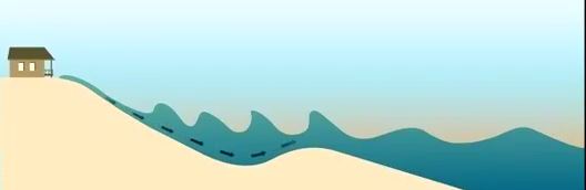


When there is sufficient undertow, items as well as sand can be dragged out.  The clip below shows the bar moved out.  The bar has flattened some (below).  It could continue to move out until it looks very much like that shown in the first clip. When the velocity of the water drops the sand drops out of transport and piles up.


If you are aware of the sands position and how it is moving, that is a big step towards knowing where you'll find objects when you are metal detecting in shallow water.  Sometimes objects get uncovered and sometimes buried, and sometimes the objects are moved too.

Whichever way the sand is moving, objects are moving in some relation to that, again depending upon the trigger points and drop points of the sand and objects.

I hope the illustrations are clear and helpful.  I had a hard time getting them fixed the way I wanted, and still didn't get it exactly like I wanted.

----

The Treasure Coast waterway cleanup will take place July 25.  I hope you will support this.  Anyone can volunteer.  It would be a great thing for clubs.

Here is the link for all the information.

http://www.tcwaterwaycleanup.com/

---

 Nestled in a north Georgia forest, over 4,000 classic cars decorate 32 acres that have been turned into a junkyard museum. Owner Walter Dean Lewis' parents started the business in 1931 as a general store that also sold auto parts. Lewis grew the collection, which had just 40 cars in the '70s, over time...


Lewis stopped selling parts about six years ago, soon after realizing he could sustain the business more as a museum, charging $15 for visitors just looking, and $25 for photographers. He estimates that 95 percent of the people who come through the six miles of trails are photographers...
Here is the link for the rest of the story.  Sorta neat.
http://www.aol.com/article/2015/07/20/ap-photos-in-rural-georgia-a-junkyard-of-classic-cars/21211215/

--

I can't believe it.  That little two foot bump in the Treasure Coast surf predictions for next week has disappeared.  We're back to one foot for who knows how long.

Happy hunting.
TreasureGuide@comcast.net

Thursday, March 27, 2014

3/27/14 Report - Lots of Clad, Movement of Ocean Debris, Trained Dolphins, and Treasure Coast Conditions


Written by the TreasureGuide for the exclusive use of treasurebeachesreport.blogspot.com.

A lot of clad was found by Steve of Iowa who hunted the Treasure Coast yesterday at some of the swimming beaches from South Hutchinson Island to Stuart.

Here is what Steve said.

In town for one day, got up early and hit Jensen Beach. Saw a long cut so
I headed right out on the mid- to south end while some guy was at the
north end. Got some clad and then hit the fisherman beach about a mile
south of Jensen. A big cut there where I found more clad. Then I hit
Stuart beach and got the most clad there, spread mostly south. Total take
was almost four dollars. Lots of fun. Met a fellow from Tennessee who is a
coin collector who wants to start detecting so I gave him some ideas on
detectors. He had a pocketful of older coins and gave me a 1916 Mercury
dime.

Steve from Iowa


Thanks for your report Steve.  Keep it up.

There are still a lot of people from up North down here.  The day before yesterday I talked to a family from Washington State who were in the area for a couple of weeks. 


There has been a lot of talk about ocean debris lately, especially as they hunt for debris from the Malaysian air liner.

You might remember me talking about how debris from the Japan tsunami circulated.  A model has been developed by the International Pacific Research Center to show how debris from the tsunami is distributed.  At first only currents were taken into account, but later the effect of wind upon lighter materials was also added to the model.

Here is an article about the model.

http://iprc.soest.hawaii.edu/news/marine_and_tsunami_debris/2012/12_08_tsunami_debris_windage_animations.pdf

And here is the model in action.  Watch the date at the top of the animation for the date as the model proceeds.

The animation shows high windage items as bright colors and low windage items as dark color.  So the items that are high windage, those items that are affected most by wind are bright orange, while those affected least by wind are dark purple.

http://iprc.soest.hawaii.edu/users/hafner/PUBLIC/TSUNAMI_DEBRIS/WINDAGE_03/ANIMATION_1/movie_windages.gif

You can see how the lightest items hit the North American continent first.  Some being turned north and some south.

You can also see how the highest windage and lightest materials eventually get separated completely and caught in limbo between currents making a line to the south of the main debris field.

Lately items like heavy logs have been hitting Hawaii.

What does all of this have to due with treasure hunting or metal detecting? 

Imagine a shipwreck, say in 1715, in which a ship gets torn apart.  There are materials that float and those that don't.  And there are materials that don't float by themselves but are in or on other materials that do float, such as on wood sections of the hull, or in boxes, or olive jars, etc.

The debris from the tsunami covered a good portion of the Pacific, some hitting from Alaska to such far away places as Hawaii.  You can see how the current circles around the North Pacific.

The tsunami debris animation might help you think bout how shipwreck debris might separate from and be dispersed before finally landing on a beach or ocean bottom.  We tend to think that everything sinks right to the bottom.    And salvage vessels are usually dealing with some of the heavier items, that without being attached to or riding in or on other things will settle to the bottom relatively quickly, but if you think about what this model is showing, timbers, sealed olive jars, and other things might end up very far from where a shipwreck occurred.  Even heavy items that are embedded in or attached to wood, boxed in crates, or sealed in olive jars or other containers could float off a good distance.

Of course we do have more light debris than would have been the case in previous centuries.  They didn't have Styrofoam or plastics, for example.  Nonetheless, I think this model is helpful when it comes to thinking about debris fields.  There may be things that end up very far from the site of the shipwreck.


The Soviet Union began training dolphins and other marine mammals to locate mines, mark underwater obstacles and detect – and if necessary kill – enemy frogmen in the 1960s. The program is shrouded in myth, but the dolphins are believed to have been trained to kill frogmen with special harpoons or knives fitted to their backs, or drag them to the surface to be captured.
They were also reported to be fitted with packets of explosives and trained to carry out suicide attacks against enemy vessels, using their natural sonar to distinguish Soviet submarines from potential targets.
Here is the link for more of that story.
http://news.nationalpost.com/2014/03/26/in-final-naval-insult-russia-seizes-ukrainian-spy-dolphins-trained-to-kill-enemies-and-find-underwater-mines/

I always thought it would be handy to have a trained dolphin or otter to do some salvage work.  I'm sure you could train them to bring back interesting looking objects.


On the Treasure Coast, the cuts that I showed yesterday disappeared by this morning.  Those were  cuts in natural rather than replenishment sand. 

The wind is coming out of the East now.  That is what was expected.  I took a look this morning even though I saw exactly what I expected.

You can probably find some more clad and modern stuff, but conditions for finding older things are  no better than a 1 on my rating scale.

These cold fronts have been coming through quickly this year.  We've been getting a little bit of north wind and then it all turns around before much develops.

Happy hunting,
TreasureGuide@comcast.ne