
Written by the TreasureGuide for the exclusive use of treasurebeachesreport.blogspot.com.
 |
| Source: usedchurchitems.com |
Some of the greatest and most meaningful 1715 Fleet finds have been religious items. I found the web site of a company that they are "devoted to preserving Catholic 'Traditional Latin Mass' church items, and invite you to experience the passion and quality of liturgical antiquities from our past."
Here is that link.
http://www.usedchurchitems.com/
One of the items I saw pictured on their web site was the lectern shown at the top of this post. Look familiar? It looks very much like the gold pelican of piety found by Bonnie Schubert on the Nieves site.
If you aren't familiar with the pelican of piety you should take a look at my 11/4/12 post in which researcher and author Laura Strolia described the significance of the item.
http://www.surf-forecast.com/breaks/Wabasso/forecasts/latest/six_day
See also the following article describing the original find.
http://archive.tcpalm.com/news/vero-beach-mother-daughter-team-find-solid-gold-bird-statue-from-1715-treasure-fleet-off-fort-pierc--345668992.html
And here is a link that will give you more about the meaning of the pelican in heraldry.
http://www.sacred-texts.com/lcr/fsca/fsca41.htm
---
 |
| Civil War Bullet and 18K Ring Find and photo by Duane C. |
Congratulations Duane!
---
Brian B. send this link to a good site that gives good surfing and weather information. Take a look.
http://www.surf-forecast.com/breaks/Wabasso/forecasts/latest/six_day
---
I've been talking a lot about the changing shoreline in recent posts. The movement of sand and other items is something that I've talked about a lot in the past. It is one of the most important things for a beach hunter to understand.
As the shoreline changes items will be brought into metal detector range or covered and put out of detector range. There are some places where you have a more-or-less progressive loss of sand or a progressive accumulation of sand. Where there is a long-term progressive erosion, you'll have a good shot at finding older items. These days they do so much beach renourishment that it is not easy to find areas that are continually eroding and uncovering newer materials.
When you get erosion of the back dunes, old items can easily wash out and down onto the beach. That mostly happens on the narrow beaches with cliffs on the face of the back dunes.
Sometimes coins and things wash up and onto the beach. I've described how that happens in the past. However before items can wash up onto the beach, they have to be uncovered. That might sound obvious enough, but it is important. As long as items are covered by sand, they aren't going to wash up. Therefore, when the shoreline is moving east (on the East Coast), more items are being more deeply covered. That covering of sand will have to be moved before those items can wash up.
One of the things I see on many of the Treasure Coast beaches now is a lot of sand in front of the beach in the shallow water. Not only does that sand cut the force of the waves before they hit the beach, but it also covers and protects buried items. If sand is eroded from a beach, it can end up directly in front of the beach and more deeply cover old items there. You can therefore see a beach that is eroded but find no old coins on the beach because they are deeply buried in the shallow water and also not being washed out of the dunes. Those are the two main sources of old coins on a beach: those washed up from in front of the beach, and those washed out from the dunes. A third source includes old coins that were originally deposited when the beach was eroded or previously washed up onto the beach and then subsequently got uncovered before either being dragged out into the water again or getting covered again.
---
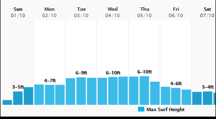 |
| Source: MagicSeaWeed.com |
This should be an interesting week. If the predictions are correct, the surf starts to build Sunday then stays high for a few days. Even if we don't get favorable winds or swells, the surf might be high enough to do some good.
Please add your response to the blog poll.
Happy hunting,
TreasureGuide@comcast.net


