Written by the TreasureGuide for the exclusive use of treasurebeachesreport.blogspot.com.
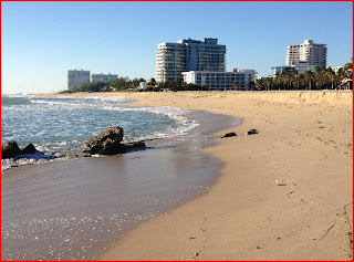
Here are two photos submitted by Michael H. showing rocks exposed by erosion and then buried again a few days later. The area is immediately south of where archaeologists discovered remains of the old fort of Fort Lauderdale. Two piles of rocks marked the sides of the old and now filled inlet. Not surprising that the old fort was near the old inlet. Also, notice the cut above the exposed rocks in the first photo.
 |
| Rocks Exposed Thanksgiving Morning. |
 |
| Sand Covering Rocks on Sunday. |
Here is what Michael said.
Attached are two photos taken in the same exact spot at low tide four days apart
at ft. lauderdale beach park....rocks were exposed on thanksgiving morning and
then on sunday completely buried in fresh sand several feet deep...notice how
the shoreline has changed and the eroded area is now closer to the buildings in
the background as opposed to first photo
if you enlarge second photo you can see a rock exposed at the shoreline in front on second building from the left and directly in front of the lifeguard stand, different outcrop of rocks than in forefront of first photo
ft lauderdale has lost the beach for several blocks north of sunrise blvd. to the ocean and this weekend cement barriers were put in place to prevent the water from entering A1A which went from two lanes each way to one each way because of encroaching seas and sand.
just found the drastic change in conditions interesting as they are rare for this area as i have never seen the rock outcrop in photo 1 completely buried in years or the rocks in photo 2 exposed...
Thanks for the photos and description Michael.
Here is the link to that story.
http://abcnews.go.com/blogs/headlines/2012/09/7-million-in-gold-discovered-in-dead-mans-home/
And here is one more good reason not to buy a deserted island in the South Pacific, or anywhere else for that matter. It could disappear. This one did.
http://www.huffingtonpost.com/2012/11/24/sandy-island-doesnt-exist_n_2184535.html?icid=maing-grid10%7Chtmlws-main-bb%7Cdl3%7Csec1_lnk3%26pLid%3D237724
I'm not really that surprised. I can think of a variety of ways that could happen. It is a big ocean with a lot of water and only a few feet less sand would be all that would be required for a small island to disappear.
The other day when I showed Joan's photo of the layers of sand recently exposed at Bathtub Beach I said you should check out the various layers of sand on a beach. Not only can you see the layers on the face of eroded dunes, but you can also sometimes see layers when you dig a hole on the beach.
The layers of sand and shell can be a fraction of an inch thick to feet. You should look at the layers when you dig a hole and notice where the coins or other objects are located. Often you'll find that most coins are located in a particular layer and sometimes they'll be between layers, and sometimes laying near the top of a layer of shells. That can all be useful information to consider when hunting.
The wind is from the west and the swells are down to 1 - 2 feet. That means you can get a little farther out in the low tide zone to check for any left overs from the recent high water.
The swells will begin to increase again soon, but not a great deal.
Low tide today will be after 1:30.
Happy hunting,
Treasureguide@comcast.net