Showing posts with label inundation. Show all posts

Wednesday, November 21, 2018

11/21/18 Report - The Importance of Tracking Beach Movement Over Time. Big Surf Predicted.


Written by the TreasureGuide for the exclusive use of treasurebeachesreport.blogspot.com.

Florida's Changing Coastline.

Beaches move.  Beach sand moves constantly.  It is a complex choreography with countless moving grains - some moving in one direction and others moving in another direction - some moving rapidly and some moving slowly.

Sand is moved by wind and water.  I'm sure that doesn't surprise you, but the consequences are important for the beach hunter.

People talk about how items sink on a beach.  As I've argued before, items on a beach rarely move if the sand doesn't move.  Prove it for yourself.  Get a bucket of sand, put a coin on the top of the sand, and you'll be able to observe that a coin won't sink in resting sand.  Coins don't work their way down into sand like sand-fleas, moles or worms.  The biggest factor is the movement of the sand.

If I wanted to find old things at the beach, one thing I'd really like to know is the history of the beach and how it has moved over time.  The beach won't be where it used to be.  The sand will come and go many times in a year.  Beach could be a long distance from where it used to be. And even when the surface looks the same, the sand could have eroded several times and then filled again.  As that happens, objects will generally tend to settle lower.

I can remember times when local different Treasure Coast beaches were very different from what they are like today.  I'm sure you can too.  I remember, for example, when an old concrete foundation was exposed at the water's edge between John Brooks beach and the condos to the north.  I only saw it once, but I'm sure it is still there.  Of course the waterline is not where it was then.  In the same area, there was also once a line of tree stumps in the shallow water.  I haven't seen them again either.  The water line at that time was much closer to the condos than it is today.

I'd love nothing more than to have a overhead stop-motion video history of the beach changes.  You'd see the beach move in and out, slowly sometimes and at other times very quickly.

People often use stationary landmarks to judge beach changes and determine when old items might appear.  It wasn't long ago that I posted how people used a car frame up by Vero to judge when hunting would be good.  That car frame is gone now, but it provided a marker to estimate the movement of sand.

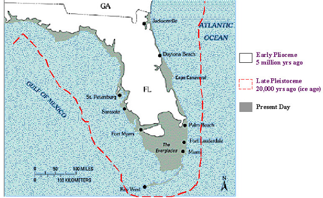
The illustration at the top of the post shows how much the Florida coastline has changed.  It changes year to year to, and even day to day.  Those changes are important to the beach hunter.  Many old objects that were once in the water are now covered by the beach, and other objects that were once on the beach are now in the water.

The beach can change quickly when there is a big storm.  Here are some photos of changes caused by hurricane Michael that did so much damage not too long ago.


The photos show how one section of beach disappeared in a very short time.  Here is the link for more about that.

https://www.usgs.gov/news/and-after-coastal-change-caused-hurricane-michael

Here is another example from the same article.


These changes caused by Michael are easy to see.  Most of the time the movement of sand occurs more slowly, but it does occur nearly continually. I'm sure that some of the erosion that occurred during Michael has been reversed by now.

I'm often amazed that people, sometimes conducting very big operations, are so far off simply because they failed to take into account beach movement. Remember, the beach is now different than it was a year ago, ten years ago, and certainly hundreds of years ago.

One of my old favorite shallow water hunting spots is now under the beach and the new waterline is out at least a hundred yards from where I hunted in the water about thirty years ago.  A beach renourishment project caused that.  If I went back there today and walked out into the shallow water, I'd be far from the area where I used to hunt and the old stuff would be deeply buried under the beach.

If you have a beach target that is dated to a general time period, one of the first things I'd recommend is that you do some research and try to find maps from that time and figure out where the beach was then relative to where it is now.

---

A six to nine foot surf is predicted for Friday.  That is a bit of an increase since yesterday.  It could get interesting.

Source: MagicSeaWeed.com.

Happy Thanksgiving,
TreasureGuide@comcast.net


Thursday, September 28, 2017

9/28/17 Report - Lost Gold Wedding Band. USGS Coastal Change Hazards Portal. More Rough Surf.


Written by the TreasureGuide for the exclusive use of treasurebeachesreport.blogspot.com.

Wabasso Beach Historical Shoreline Changes.
Source: https://marine.usgs.gov/coastalchangehazardsportal/
The USGS has an interesting web site that shows historical shoreline changes, including Florida. The snipping I posted above shows the Wabasso area.  If you look at the key and then the map, you'll see that back in the later 1900s the shoreline was farther out than it is today, but also farther out than it was in the mid-1800s.  It hasn't progressed continually in one direction or another, but has come and gone to some extent at various times because of both natural causes and beach renourishment.

Historical Shoreline Changes Around Fort Pierce Inlet
Same source.
There are a lot of interesting things you can find on the coastal hazards portal.  I didn't zoom in so much for the above image, but you can see that north of the inlet the shoreline is now farther out in the 2000s than it was in the mid-1800s, and south of the inlet, the shoreline is farther back in recent years than it was in the mid-1800s.  That is natural. You typically get accretion north of east coast the inlets and erosion south of the inlets because the supply of sand is cut off and that starves the beaches to the south.

If you look at the coast towards the top of the map, you'll see where the old St. Lucie inlet was.

I am showing these examples to highlight what I believe to be a very useful tool.  Here is another example.   The area is just south of Bathtub Beach.


You can see where back in the 1800s the shoreline jutted out.  Now the shoreline is much farther back than it was at that time, but it is more seaward than it was the the 1900s.  That is probably due to beach renourishment.  You can also see the rocks at the present shoreline.

Too bad they don't show us where the beach was in 1715.  That would be very useful.


Here is another example from the coastal change hazards portal.   This one (below) shows the probability of inundation and overwash from Irma.

Areas of Irma Inundation and Overwash.
Souce: USGS coastal change hazards portal.
You'll have to visit the site and take a closer look at this one with the key etc.

Another part of the same site shows that maria affected the South Carolina and North Carolina shoreline the most.

Here is the link if you want to really explore that web site.

https://marine.usgs.gov/coastalchangehazardsportal/

---

People are acting like the surf has gone smooth.  It hasn't.  Look at this.

Source: MagicSeaWeed.com
And Sunday the swells are supposed to be more northerly.  Something good could happen yet.

A lot of people got excited when they heard there was going to be a hurricane.  Everybody got ready.  Then a lot of them went out and were disappointed. 

How many times have I said, it doesn't take a hurricane.  I recently posted about the 1984 Thanksgiving storm.  That was no hurricane, but there was a lot of treasure found.  I'm getting the feeling that a lot of people are starting to snooze after all the hurricanes passed by.  That might be a mistake.  There is still a lot of good surf predicted for the next week or two.  If it wasn't for the very high surf we've had lately, the surf that is predicted now would be getting people excited.  I'm just thinking that people might be giving up too soon.
---

I got a report from Kevin K.  Here is what he had to say.

I went to Frederick Douglass and John Brooks beaches yesterday to hunt, using my ground-penetrating radar machine and my Bounty Hunter Landstar detector. The surf was, indeed, running 5-8 feet with many breaking on the first reef - wish I’d had a surfboard! As you said in yesterday’s blog, it looked like new sand had been added all the way up to the permanent dune, and I did not get one hit on the metal detector, although a lot of false readings on all-metal mode. Those readings must have been mineralized sand, as the discriminator mode never showed anything. The radar machine did not show any deep targets down to 10 feet, although up near the dunes some areas showed disturbed sand as deep as 5 feet...

Thanks for the report Kevin.

Kevin also lost a gold wedding ring in the process and is hoping it can be found.  Here is how he described that.

Somehow I did manage to lose my gold Claddagh wedding ring probably near the Douglas pavilion or in the parking lot of the street north of the Brooks Beach entrance-so if anyone finds the treasure I left, I’d like it back!

Let me know if you find Kevin's ring,, and I'll hook you up for the return. 

Kevin might also be able to do some ground-penetrating radar for you.  His business is Underground Discovery, LLC.

---

That is all for today.

Happy hunting,
TreasureGuide@comcast.net

Wednesday, August 30, 2017

8/30/17 Report - U. S. Geological Survey Web Site That Shows Areas Expected To Undergo Coastal Change Events. Harvey and Tropical Storm Ten Coastal Change Area Maps.


Written by the TreasureGuide for the exclusive use of treasurebeachesreport.blogspot.com.

U. S. Geogloical Survey Coastal Change Hazards Portal
Source: See link below.
Here is a great tool for identifying coastal areas likely to significantly erode.  It is the U. S. Geological Survey Coastal Change Hazards Portal.  The above picture shows the areas identified for coastal change due to Topical Storm Ten.  The bright red shows a high (97% probability of storm-induced collision and specific areas of South Carolina.  A good portion of the South Carolina beaches is marked.  If you go to the site, you can zoom in for a more detailed map and more specific information.

Here is the link


Texas is obviously going to have a lot of erosion - both coastal and otherwise.  I hate to think of the disaster as a metal detecting opportunity because the human loss and suffering is the highest priority, but this is a metal detecting/treasure hunting blog.  I'd encourage everyone to think of the human needs in Texas first and perhaps contribute to the relief effort in some way if you can.  I always end up passing up some of the best metal detecting opportunities during hurricanes because I think there are more important things to do.  There are people that need help.  We can, however learn a few things from the unfortunate event.  Earth and sand will be moved and historic items will be exposed that should be recovered before they are lost.  Despite what some would have you believe, they won't last forever and in many cases the archaeological context has been destroyed.

Using the U. S. Geological Survey Coast Change Hazards Portal, here is a look at the Texas coast.

U. S. Geological Survey Coastal Change Portal Showing Texas Coast.

As you can see, much of the Texas coast is in danger of inundation or overwash.

Below I zoomed in on an area near Corpus Christie Bay.


Area Near Corpus Christie Bay
Source: U. S. Geological Survey Coastal Change Portal
I'll added the link to my reference list.  You will find on the first page under the poll, surf and tides, and followers.  

This is one very useful tool.  You can watch it for future Florida coastal events.  

---

Source: nhc.noaa.gov

Unfortunately Harvey hasn't moved much yet.

The system out by the Canary Islands has a 90% chance of becoming a cyclone in the next 48 hours. It could be headed our way.


On the Treasure Coast we have a one to two foot surf.  The wind will be from the north this morning, shifting back to the south later in the day.  The tides are small now.

---

The blog poll is progressing nicely.  Almost 100 people have responded so far.  It would be nice to get that number.  Only a short time left to respond.

You might want to play around with the Coastal Change Portal a little.  I had some other things to post today, but decided to put them off for another day.

I was looking for an old find and ran across what appears to me to be a strange error coin.  I also found some other good web sites.

Happy hunting,
Treasureguide@comcast.net