Showing posts with label winds. Show all posts

Saturday, August 31, 2019

8/31/19 Report - Dorian Expected to Make Turn and Head North Along the Treasure Coast. 11AM Update In.


Written by the TreasureGuide  for the exclusive use of treasurebeachesreport.blogspot.com.

MagicSeaWeed.com.

Above you can see the MagicSeaWeed surf predictions for the next few days.  As you can see, they are expecting some high surf for two to three days.

There is a northeast wind for a while on Sunday, becoming a north/northwest wind Monday and then a west wind Tuesday.

We are also in a King Tide cycle.  A spring tide—popularly known as a "King Tide"—refers to the 'springing forth' of the tide during new and full moon.

Overall, there is a good chance for significant erosion.

The current predicted path has the storm passing over Grand Bahamas and heading directly for Fort Pierce before it makes a turn north and up along the Florida Coast.

8/31 5AM Cone.
Source: nhc.noaa.gov
I just looked at the 8 AM update, and the new cone is so similar that I didn't bother to replace the 5 AM map.

The GFS model now shows a track farther east than the EDMWF model.  What you see above is the National Hurricane Center's prediction, which takes the various models into account.

Now that they show the center remaining off-shore, don't get too complacent.  We still have about a 50 percent chance of receiving hurricane force winds. As you've seen the past few days, this is far from an exact science.  Things can, and probably will, change by the time this is all over.

Hopefully, you have made your preparations and have a plan for your family.

Do not be overly comfortable or confident.  Dorian is huge and could still come ashore anywhere.  Most of Florida remains in the cone.  The winds near the center are 145 mph as I write this.  Hopefully we won't get anything that strong.  That can blow roofs right off.

As the storm approaches the coast, we'll get some north winds, but after it turns north, we'll be on the south side of it and the winds will start to become west winds.   That is if the track remains as shown above.

I'd expect some big storm surges up in the north of Florida and Georgia.

There will be strong winds and a high surf.  Be careful.  I've described many of the dangers before.  You could encounter a lot of debris in the surf, including trees, logs and other things that could knock you off your feet.  I've seen people get knocked over, and I've seen people lose their metal detector to the surf.  DON'T get caught between a cliff and big wave smashing into it.

Get your preparations done.  Get your equipment charged and in good order.  You'll want to be prepared for rain and blowing surf as well as wind.

That is all for now.

---

11 O'clock Update.

The eleven o'clock update is in and the NHC cone and track of Dorian remains almost the same as the previous one.

---

Stay safe,
TreasureGuide@comcast.net


Sunday, November 11, 2018

11/11/18 Report - Thanks Vets! Little Cutting on The Treasure Coast Beaches as Front Passed Through. Hurricane Map Active Again.


Written by the TreasureGuide for the exclusive use of treasurebeachesreport.blogspot.com.

John Brooks Beach Sunday Afternoon.

We had a little front come through yesterday.  It seems like we've had five or six fronts over recent months that have done about the same thing.  When the front comes through and the wind come from the north/northeast and we get a little cutting, but then as the front passes, the wind changes and that is the end to that.  The sand starts filling again.  One or two tidal cycles of north winds and cutting is about all we've been getting.  You check the wind patterns on Ventusky.com.  It is really helpful.

There was a fellow metal detecting at John Brooks.  You can see him in the wet sand in the above photo.

Here is how it looked yesterday and into this morning when we were getting a northeast wind and when a little new cutting occurred.

Wind Map
Source: Ventusky.com.
If you want to see the progression, check Ventusky.  You can pretty much tell when there is a possibility of cutting.

The sand in front of the cuts is mushy until you get close to the water.

Frederick Douglass Beach Sunday Afternoon.
\The cutting was a bit smaller at Frederick Douglass Beach.  You can see that above.

It was still too warm on the beach for my liking.  The snow birds are arriving.

Up north the leaves change color in the Fall.  In Florida the license plates change color.

Surf At Frederick Douglass Sunday Afternoon.
What I wanted to show with this photo is the brown water where the surf was breaking and picking up the sand.  That doesn't show though.  You could see where it was washing up onto the beach after the cutting occurred.

Although hurricane season is almost over, there is some activity on the National Hurricane Center map.

Source: mhc.noaa.gov
As you can see, the system is east of the West Indies.  It has a less than 40% chance of becoming a cyclone in the next forty-eight hours.  If it continues to develop, there is a good chance that it comes toward us.  Right now it is too early to tell what will happen.

The surf is not going to get much higher tomorrow - just a touch.

Source: MagicSeaWeed.com

Don't expect the beach detecting conditions to improve much any time real soon.

Once again,
Thanks vets!

Saturday, September 9, 2017

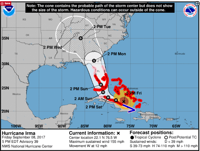
9/9/17 Reportt - Saturday PM Update Added - Irma Trending Towards The West Coast of Florida. An App or Two That Will Help You Get To The Beach.


Written by the TreasureGuide for the exclusive use of treasurebeachesreport.blogspot.com.


Source: nhc.noaa.gov
As you might be able to tell from the NHC track above, as of yesterday afternoon, the track moved more to the west.  coming in closer to Naples than Miami, and expected to proceed up through the state closer to Tampa than Canaveral.  If that is what actually happens, the Treasure Coast won't get the kind of damage that it would if the track stayed more east.

Now they are concerned about the storm surge that might occur on the Florida west coast.

Our surf predictions have decreased too.

Source: MagicSeaWeed.com
Yesterday they had something like a 22 foot preicted surf, now the biggest is 14 feet.  That is still to occur late Sunday.

Fourteen feet is still a lot more than the two or three feet that we have been getting most of the summer.

If the current MagicSeaWeed predictions are correct, we're not going to get the north winds either now.  Instead they will be east/northeast but mostly east.  That means that not only will the water not be as high into the dunes, but we'll probably get less erosion.  I'm not saying we won't get any.  We almost certainly will get some at various locations.  And it doesn't always take cuts to produce cobs.

After the storm and the east winds pass, we'll quickly be back to south winds - again if the predictions are correct.  That would mean that the beaches would start to refill again.

All of that, of course, is based upon what they think Irma is going to do, which might or might not be correct.  We'll see.

I've heard some say that we won't have much damage to buildings. I wouldn't mind that.  They are saying it will be more of a tree thing.  I won't mind less property damage.  Maybe - just maybe - the damage will be light enough that the beaches won't be closed.  Again, we'll see.

The predicted track could change again, but I don't think it will change much.  The models are agreeing more and the changes seem to be less frequent and drastic.

---

In following Irma I found some good web sites and mentioned them.  Some I posted.

One very interesting thing I found is a traffic app.  Go to googlemaps.com.  From the menu select the "traffic" option.  You will then see a map showing how heavy traffic is on the roads.  That is useful.
One day the Turnpike was jammed and traffic at a crawl or less at a lot of locations. You could take a look at the web site and choose another route if you found one that was moving better.

I saw there was a slow down at a corner near my house, so I went out and looked down the road to see it.  At the time I didn't know how it was done, but I did see the slow moving cars represented by a red line on the map.

You might wonder how google can show the traffic flow for roads all over the state and country.  The answer is they can track people with Android phones and how fast or slow they are moving, and of course they can tell where they are.  That is pretty amazing, but you might not want to think you are being tracked like that.  You don't have to because you can turn off the location data from your phone.

Check it out.  I found it to be a very useful web site.

Before you can do any metal detecting, you have to get there.  You might also like Gas Buddy, which will tell you where they have gas and the price.

---

I received some nice emails from some of the fine and thoughtful people that read this blog.

Thanks to all.

Janine K. sent the following message.

Thinking of all you Floridians and sending thoughts for a safe outcome for all. 

Thanks Janine!

---

Saturday 5 PM Update.

Beach erosion has begun on Fort Pierce beach but the bridges are closed - residents and business owners are among those permitted on the island.

The wind and surf is increasing - mostly from an easterly direction.


Be safe,
TreasureGuide@comcast.net

Saturday, July 9, 2016

7/9/16 Report - Why North/Northeast Winds Create Good Conditions and Wash Treasure Onto The Beach. Next Sedwick Auction. $15,000 T. C. Beach Find.


Written by the TreasureGuide for the exclusive use of treasurebeachesreport.blogspot.com.


Everybody talks about cuts when they discuss finding shipwreck treasure on the beach.  So what is so different when there are cuts?

There are two basic ways that old treasure items can suddenly appear on the beach.  They can either be uncovered when sand erodes from the beach or they can be washed up onto the beach from the ocean.

Some people say that cobs wash up onto the beach, and some say that they are uncovered, but I think most people now accept that it happens both ways.  I am certain that it happens both ways.  In the past I've discussed trigger points, drop or settle points and the various other factors that determine how and when it happens.  I've also explained how north/northeast waves are more effective at creating cuts and why.  Now I am going to discuss what happens differently when there are cuts and when the water is high and continues to hit from the north/northeast.

When the water is hitting the beach straight on without much of an angle, the water washes up onto the beach, slows, and then washes back down the beach.  When the water slows beyond what I've previously described as the drop point, items that were being carried or moved by the water drop out or settle onto the beach.  That includes sand and other small items.  Exactly where and when that happens depends upon the force of the water and various characteristics of the item.

Another thing that happens when the water washes back down the beach is that it runs into water coming up onto the beach.  Where and when that happens depends upon the period of the waves.

When the incoming and outgoing water collides, items are dropped and settle, at least momentarily. Where that happens will also depend upon the tide.


What happens differently when the water is coming from a good angle from the north/northeast is that the water goes up onto the beach and makes an arc..  It does slow some but does not slow and reverse as abruptly and does not collide directly against incoming water.  As a result there is relatively continuous flow and slicing action (as shown on the right side of the illustration).

When the water slices over the beach when it comes from an angle, the more continuous flow does not drop off smaller items.  In fact the flow can pick up more sand and take it back into the water where it is carried by the long shore current.

There is yet another important factor.  The water sometimes hits the face of the cut very forcefully, loosening sand that slides down the face of the cut and into the water which carries it back into the ocean.

When water hits the cliff forcefully, the backwash coming off the face of the cut can be very rapid, taking more sand away.

The water can move rapidly enough to take both sand and coins with it.  Or, when the water slows enough to drop the heavier coins, it can continue to take sand.

Also take into account the rising and outgoing tides and any change in water direction.

One other factor is the north to south long shore current.

---

I've been informed that it is not too early to consign to the Fall Sedwick Treasure, World and U.S. Coin Auction #20, which will be their fourth live public floor sale. They have secured the DoubleTree by Hilton at Lake Buena Vista in Orlando, FL, and have locked in the date: November 11-12, 2016 (with lot viewing and Guest Speakers on Friday, November 11 and lot pick-up and Numismatic Forum on Sunday, November 13). Let them know now if you plan to attend, so that they can make a preliminary head count and expand the room-block reservation if necessary.

---

Aa $15,000 Rolex watch was found on a Treasure Coast beach.

---

We still have several days of one-foot surf ahead of us.  There are no storms forming yet.  This hot weather and water surely will create some storms - not that I want to see any hurricanes.

Happy hunting,
TreasureGuide@comcast.net