Showing posts with label Hurricane Irma. Show all posts

Saturday, December 30, 2017

12/30/17 Report - Increasing Surf Along Treasure Coast and Beach Photos. Shards. # 5 Most Popular Post of 2017.


Written by the TreasureGuide for the exclusive use of treasurebeachesreport.blogspot.com.

Pepper Park Yesterday Morning.
Photo by Alberto S.
Alberto S. visited Pepper Park and Fort Pierce South Jetty Beach yesterday morning and sent these photos. 

Fort Pierce South Jetty Yesterday Morning.
Photo by Alberto S.
Since the higher surf had begun I wanted to see what was happening at the beach, so I went out yesterday afternoon to take a look.  Below is what I saw.

John Brooks Beach Yesterday Afternoon Before High Tide.
Frederick Douglas Beach Yesterday Afternoon Before High Tide.
You can see that at both John Brooks and Frederick Douglas the water was getting up over all the newly accumulated front beach.  It was getting as high as it has been for quite some time and it was not high tide yet.

Frederick Douglas Yesterday Afternoon.
You can see the sand along the berm of the front beach here.  That irregular spot to the left is an area that has been interesting for months now.

The water is getting high enough that there might be some spots that open up at some other beaches after the next high tide or two.

---

As you probably know I have been listing the top ten most popular posts of 2017.  It has helped me get an overall perspective on the year and what has been most interesting to the blog's readers.

My number five most popular post of the year was another one of the September posts having to do with Hurricane Irma.  As I said before, five of the top ten posts were done in September.  That was a busy time for Treasure Coast detecting this year.

Number 5 was the 9/12/17 post on some of the first Hurricane Irma finds that were reported.  Below is that link.

http://treasurebeachesreport.blogspot.com/2017/09/91217-report-early-irma-treasure-coast.html

A lot of musket balls and lead were found after Irma.

---

Consensus on the ceramic pieces found by Gaylen and shown in yesterday's post seems to be that they are not from old shipwreck pottery.  I am always very hesitant to evaluate pieces like that from just seeing photos, and other readers felt the same way, however, they do not look like either olive jar shards or majolica.  My first impression, though I was hesitant to say anything on that basis alone, is that they look too hard and dense and the edges are too sharp.  I was waiting until I studied it a little more before I said anything specific, but the responses I received via email seemed to be in line with my first impression.  I hope to take the time to study those pieces a little more so I can be more specific and perhaps show some examples of the real thing and how they differ.

You might look at my 11/18/12 and 11/19/12 reports, for example.  I am obviously far from an expert on shipwreck pottery or ceramics, but you have to start somewhere.

Here is the link to the 11/18/12 report.

http://treasurebeachesreport.blogspot.com/2012/11/111812-report-sherds-or-shards-water.html 

Of course there are books and resources that you can consult that are much more authoritative and thorough.

---

The most important topic today is the surf.  As I mentioned yesterday, it is getting bigger and hitting higher up on the beach.  Some spots might open up.

Here are the surf predictions for the next week.

Source; MagicSeaWeed.com.
Happy hunting,
TreasureGuide@comcast.netn

Wednesday, December 6, 2017

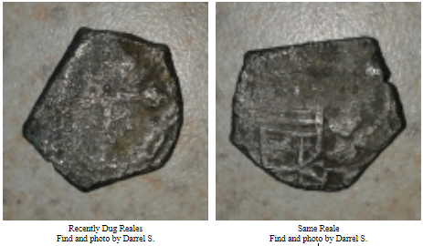
12/6/17 Report - Ring of Well Known Person Found After Being Lost On A Florida Beach For Decades. Another Reale Find On The Treasure Coast.


Written by the TreasureGuide for the exclusive use of treasurebeachesreport.blogspot.com.

Some Nice Coins and a Ring Found Sept. 25.
Finds and photo by Chris N.


Below is a message I received from Chris N. who found the items shown above.

I found this ring belonging to Fairleigh S Dickinson Jr of New Jersey. He was an avid fisherman, adventurer, businessmen, New Jersey Senator, and instrumental in laying out the plans for the Meadowland Complex along the Hackensack River in East Rutherford New Jersey. Also note His father was Farleigh Dickinson Sr. who help start Becton Dickinson Medical formally in that area as well as the University in Rutherford, NJ.  He attended the New York Military Academy in Cornwall,New York, and the Ring was dated 1937. .And was in the United State Coast Guard in the 1940's.

With help of the Police departments in New Jersey and a little research,we were able to get the ring back to the family, who were astonished that we went through all this trouble to get it back to them. They were surprised and happy that Metal Detector Enthusiast do their best to try and return items. "Thats what we do"

He passed away in 1996, and I was informed that they had no idea the ring would ever be found. We can assume that "Hurricane Irma and the Nor'Easter shortly between each other exposed the original hard pack in which we were able to pick it up on the Metal Detectors September 25, 2017. {Using a Garrett AT Pro, and Mine Lab Sovereigns  GT}

Extensive erosion inadated the Northern Florida coast where ring was found. 
Amongst other items found were old coins dated 1895 and later to Modern Clad, other Jewelry Items, Copper Sheeting, Ballast Rocks, but no Spanish Coins!!! Yet?


Found Ring With Name Clearly Inscribed Inside
Find and photo by Chris N.

Thanks Chris for all of the good work involved in getting it back to the family and providing some more good PR for the metal detecting hobby.

Congratulations of the great finds as well!

Florida beaches have long attracted people from around the country and around the world.  That is one thing that makes detecting here so interesting.


---

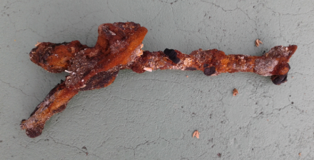
Below are some items found by Darrel S. not long ago. 

Fused Bolts.
Photo by Darrel S.
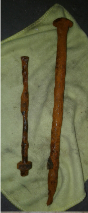
Darrel S. sent me the above photo of the two dug fused bolts or spikes and then the picture below of the same items after they were cleaned.

Bollts After Cleaning.
Photo by Darrel S.

Here is something else he found with the bolts.


Thanks Darrel.

---

We''re still having some big tides on the Treasure Coast, including a nice negative tide in the early AM hours.  The surf is going to be only around two or three feet.

Happy hunting,
Treasureguide@comcast.net


Friday, October 27, 2017

10/27/17 Report - Irma Uproots More Than Trees. Beach Changes Overnight. More Thoughts On Mystery Object. Cyclone Developing Now.


Written by the TreasureGuide for the exclusive use of treasurebeachesreport.blogspot.com.

Photos by Joe D.


Yesterday I received the following message along with the attached photos from Joe D. 

Just read today's [ yesterday.s ] post.  I was out before sunrise to continue hunting the same area as yesterday, which was about 21 hours ago.  And the beach had drastically changed in that span of time.  The sandbar that I mentioned yesterday had made landfall with a vengeance and made anymore hunting here pointless for now.  (See pics for a same spot comparison).  But the sunrise was fantastic!             Also, here's a large piece of debris that had to have come through one of the inlets, or from the Keys via the gulf stream.  It's a large chunk of mangroves and soil, and probably weighs several thousand pounds.      Joe D.


Thanks for the report and pictures Joe.

---


Hurricane Irma Uncovered Native American Artifacts.

Archaeologists are sifting through the root balls of twenty trees on Marco Island that were uprooted by Hurricane Irma to see what Calusa artifacts might have been uncovered.

Here is the link to that story.


Just before I read about that, I read an email from Darrel S. about checking where trees have been uprooted.

I talked about various sources of erosion yesterday and should have mentioned that I do always check where trees have been uprooted.  A lot of the time I have found nothing there, but a few times I have made nice finds that way.  A few were 1715 Fleet finds.

---

I think the mystery coin that Steve found does show a Cuban seal on one side.  Thanks to Brian M. for pointing us in the right direction.  Both Steve, who found the coin, and some readers question if the other side matches that of a ten centavos coin.  Joe D. sent this picture of a two centavos coin with the following message.


Picture of Two Centavos Submitted by Joe D.


 Joe said,   I was just comparing Brians coin picture with the one posted today and I noticed something in the star that didn't mesh. I looked on coinect.com and found what I think is a better match for the star. It's a 2 centavos based on the pattern I see in his pic ( here's a pic). The 1 and 5 centavos don't match either, so I believe it's the 2!

The trouble with that is that Steve believes the coin to be silver.  The two centavos is not.

The earliest Cuba coins with that kind of seal was the 1915 coins.  A similar seal, but one that looks to me less like that on the mystery coin, was used as early as 1897, but those coins had a female head facing right  on the other side.

Here is a good link for Cuba coins.

https://en.numista.com/catalogue/cuba-2.html 


I like the process of how these mysteries get closer to a solution over time.  We make progress with each step as different people contribute and we have to take new facts and opinions into account.

Christopher P., on the other hand, thought mystery coin might be a badly worn medallion such as the "First Communion" medallion shown below.  He sent the following example.

First Communion Medallion
Submitted by Christopher P.
I guess there is some possibly it could be a medallion rather than a coin.  Lets see what Steve, the one person that has the advantage of looking at the coin in person, thinks.  I don't know if we have an exact match yet, but I think we are getting closer, thanks to those who have contributed their research and ideas.

---

It isn't too late to have a hurricane.  In fact right now there is a system developing down near Mexico that has a 50 percent chance of becoming a cyclone in the next 48 hours.

Source: nhc.noaa.gov
On the Treasure Coast we'll have a couple days of small surf.

The cool air is more comfortable than all those 90 degree days we had this summer.

Happy hunting,
TreasureGuide@comcast.net


Saturday, October 21, 2017

10/21/17 Report - Could Irma Find Be Oro Corriente? Salvaged Silver Bars: Markings and Manifest.


Written by the TreasureGuide for the exclusive use of treasurebeachesreport.blogspot.com.

Gold Found on Treasure Coast Beach by Ken A. After Irma.
You might remember the Irma 1715 Fleet beach gold find made by Ken A..  I showed it just a few days ago.  Here it is again.

I noticed a piece of oro corriente in the Sedwick auction and thought it looked very similar to Ken's find.  

Lot 20 in Current Sedwick Auction.
Here is the description of the auctioned piece.

Gold "oro corriente" cut piece with choice full "f" stamp for Ferdinand V of Spain, 80.10 grams, from an unidentified early 1500s wreck in the Caribbean. 1-5/8" x 1/2" x 1/2". Rectangular edge-cut of a thick gold disk of undetermined fineness (probably around 20K), with three sides (all but the outer edge) crystalline in texture (broken, not sliced), granular bottom but smooth top marked with partial circular tax stamp and full "f" in box, believed to be one of the earliest markings known on "oro corriente" pieces (used in place of coins in areas where coins were not yet made or available), with small spots of black but otherwise fairly clean. From an unidentified early 1500s wreck in the Caribbean.

It looks like Ken's piece could be a piece cut off a larger piece.  It would not be easy to see if there are any marks inside the rolled piece, but Ken should take a good look for any sign of a mark.  I'm sure he did.

Ken's piece could have been intentionally bent for easy concealment or other uses or bent by the forces of nature over the years.  

Anyhow, it looks to me like that could possibly be what Ken's find is.  Or maybe just a cut piece.

---

Atocha Silver Bar in the Current Sedwick Treasure Auction.

A few days ago I briefly talked about this Atocha silver bar that is being auctioned in the current Sedwick treasure auction.  The stick-figure TA monogram. or what the auction catalog calls a cartouche, is the kind of thing that really interests me.  It indicates a specific person, the owner/shipper.  In this case the owner/shipper was a man named Tirajo.  I decided to look into the subject of such owner/shipper marks a little more.  It turns out that they have been well studied and there is a lot of documentation on them.

There were 1,038 ingots on the Atocha.  A number of ingots were from Potosi, but the above ingot was from Oruro.

A register of the Atocha cargo was maintained by the silver master, Jacove de Vreder.

Corey Malcom did an article entitled Simon de Torres' Shipment of Five Silver Ingots Aboard the 1622 Galleon Nuestra Senora de Atocha, which was published in The Navigator: The Newsletter of the Mel Fisher Maritime Heritage Society, Vol. 23, No. 1, January/February 2007.

The five ingots that were the subject of Malcom's study were owned by another private shipper, Simon de Torres.  Here is what Malcom's study has to say about those ingots.

All of those ingots bear Torres’ distinctive “TR” sigla, along with mintmarks, tax stamps, fineness values, registry numbers, and assayer’s bites. Each bar in this shipment also bears marks whose purposes are not recorded or understood. Chief among these, a large “V” is believed to be the mark of the Atocha’s silvermaster Jacove de Vreder, who would have stamped this after registering the ingot. (An alternate theory suggests that it might be a Roman numeral five, symbolic of the quinto, a tax of one-fifth the value of the bar.) Most of the Atocha silver ingots bear this particular mark. Also, a cross, which is found on these particular bars in association with the “V” stamp, suggesting it had some sort of official function. Two other stamped marks are a small, well-defined Omega near the assayer’s bite on bar number 346, and an unusual “X” near the bite of bar number 342. It is assumed these two also served an official function because of their purposeful placement so near the assayer’s sample.

Here is an illustration explaining the various marks on the silver bars.

Source: Malcom Study
See link below.

It is not often you can find so much information about a treasure find.  It is fortunate that the treasure is so well marked and the ship's manifest is available to document these pieces.  In my opinion, that makes the treasure much more valuable.  Not only do we have the existing bars, which have been salvaged, but we can also track them to a particular person, source and destination.

Although we know much about the five salvaged silver bars that Simon de Torres was shipping, we don't know what happened to him.  Maybe he was lost at sea like his five silver bars that were salvaged in 1985.

Here is the link to the Malcom study.

http://www.melfisher.org/pdf/Torres_Five_Silver_Ingots_Atocha.pdf

The study is not long but very informative.  You might want to read it.

The registered silver bars on the Atocha were generally well marked like those of Simon de Torres.  Not all silver bars being sent to Spain from the New World were so well marked.  Below are two more examples from the Sedwick auction.

Lot 217 Current Sedwick Auction.


Lot 218 Current Sedwick Auction.

Sometimes there are multiple marks, indicating multiple shipper/owners.  Sometimes one mark would be over top of another, perhaps indicating transfer of ownership.

The information found on these bars is unusual and provides an excellent starting place for additional research on the individuals and history of the New World.

You'll find, though, that not all silver bars are so well marked.  Some silver ingots and bars are not marked at all, perhaps being smuggled and therefore not listed on the ship's manifest.

Here is another Atocha silver bar.

Source: Christies web site.
See link below.
Here is the link describing that bar.

http://www.christies.com/features/Jill-Waddel-examines-a-silver-ingot-from-a-shipwreck-8022-1.aspx

You'll find a variety of Atocha bars on the internet, many with the kinds of cartouches you see above.

---

On the Treasure Coast today we have a four to six foot surf.  The temperature is a little lower.  That is nice.  The swell will be from the east.

Happy hunting,
TreasureGuide@comcast.net

Tuesday, October 17, 2017

10/17/17 Report - Large Atocha Silver Bar With Interesting Monogram. The Soothing Beach. Tornado From Irma.


Written by the TreasureGuide for the exclusive use of treasurebeachesreport.blogspot.com.

Large Atocha Silver Bar
Lot 216 in Current Sedwick Treasure Auction.
The cool thing to me about this large silver bar is the TA monogram in the shape of a human stick figure.

Here is the auction description.

Large silver bar #626, 89 lb 11.68 oz troy, Class Factor 0.8, with markings of manifest 1038, fineness 2380/2400 and mine/date cartouche ORVRO / 1621, from the Atocha (1622). 15-3/4" x 5-1/4" x 3-1/4". A particularly large ingot with strong markings on top (should be at least Class Factor 0.9) including a very deeply impressed diamond-topped-TA monogram (for owner/shipper Tirajo), very bold IUXXXVIII manifest number, full but corroded fineness IIUCCCLXXX, silvermaster V (de Vreder) in one corner and full but lightly corroded (but all-important) rectangular cartouche with mine name ORVRO above date 1621 (the presence of which should merit a Class Factor of 1.0), plus the usual cylindrical assayer's "bite" at one end, yet with all of the circular tax stamps too weak to discern, tiny bits of charcoal embedded in sides, overall well above average for these popular "loaves" of silver. From the Atocha (1622), with Fisher photo-certificate #85A-S626 and original gray plastic TSI tag.

This lot currently has a bid of $22,000 and is sure to go much higher.

Not only is this a great silver bar, but the imaginative monogram shows the creativity of the owner/shipper, Tirajo.  Really a great human touch that survives the centuries.

The ORVRO mark refers to Ururo, which is the Spanish name for Uro Uro in Bolivia.

According to Wikipedia, The city was founded on November 1, 1606, by Don Manuel Castro de Padilla. as a silver-mining center in the Urus region. At the time it was named Real Villa de San Felipe de Austria, after the Spanish monarch Philip III. It thrived for a while, but it was eventually abandoned as the silver mines became exhausted.

---

It is said that being at the beach provides mental and physical health benefits.

According to one article, “The color blue has been found by an overwhelming amount of people to be associated with feelings of calm and peace,” says Shuster. “Staring at the ocean actually changes our brain waves’ frequency and puts us into a mild meditative state.” A study published in the American Association for the Advancement of Science’s journal even found that blue is associated with a boost of creativity.

The smell of the ocean breeze contributes to your soothed state, which may have something to do with the negative ions in the air that you’re breathing in.

Plus,that consistent ebbing and flowing you hear as you lie on your towel under an umbrella? “It kind of de-stimulates our brains,” says Shuster. The noises — coupled with the visuals — activate your parasympathetic nervous system, which is “responsible for slowing us down and allowing us to relax and feel more engaged,” says Sally Nazari, PsyD, owner of Chrysalis Psychological Services and host of the podcast Beyond the Couch...

But it turns out there’s a bit of a placebo effect happening, too...


Here is a link for more about that.

https://www.nbcnews.com/better/health/what-beach-does-your-brain-ncna787231

---

Hurricane Irma was the beginning of a very hectic time for me and a lot of other people.  I won't go into all of the details, but I just haven't been able to get back to normal since.

A little tornado passed very near my house.  I happened to see it go through.  It was something to see.  A huge electric poll swayed and trees snapped over like paper napkins.  The sound was something too.

Path of Tornado Through Wooded Area.
There was a path torn through the wooded area.  Above is a little of that path.

Below is a picture of one limb ripped off by the Tornado.  Large trunks and limbs broke off.

Limb Broken by Tornado Associated With Hurricane Irma.
I talked a lot about Irma, but I haven't mentioned how it opened up some heavily wooded areas that were difficult to detect before.

Towards the end of next week it looks like we could have a decent size surf - up to six or seven feet.

Happy hunting,
TreasureGuide@comcast.net


Wednesday, September 13, 2017

9/13/17 Report - Irma Finds. Bridge Openings and Beach Accesses Closed. Some Beaches Cut.


Written by the TreasureGuide for the exclusive use of treasurebeachesreport.blogspot.com.

Haul From One Low Tide.
Photo submitted by Captain Jonah Martinez
Holes Where Recoveries Made
Photo by Captain Martinez

I'm still struggling with a strange computer that won't pick up the photos from my cell phone, so this post isn't going to be as good as I hoped.

I took some beautiful beach photos this morning but you aren't going to see them until later.

The bridge to South Hutchinson Island was open this morning.  I assume that the bridge to North Hutchinson Island was also open.  However the John Brooks beach access was closed this morning.

Jonah told me that 510 was open.  He said they were hunting Sunday AM and then the beach starting filling again.

At John Brooks there was a substantial cut this morning from the condos and north of that, which ran down at least to Frederick Douglas.  It was about four feet high and pretty far back towards the dunes.  I would say at the John Brooks walkover the cut was back to about forty yards in front of the walkover.

In front of the cut. there was a lot of mushy built up sand.  There were a lot of nice shells.  It was a good day for shell collectors.

For beach metal detecting overall, I'd rate conditions as no better than a three on my five point scale.  I would not be surprised if it deteriorates until Jose sends us some good north winds.

The only beach I saw was John Brooks so I'm going on the basis of what I saw and the reports I received.  So far I'm very iffy on my rating.

If this computer was cooperating better, I would explain my rating scale again.

Too bad I couldn't post the pictures I took, but I'll get another look at the beaches sometime soon and hopefully be able to post more photos.

I don't really know why the John Brooks access was not open today.  I suspect more beach accesses will be open tomorrow, but can't say which ones will or won't.  Sometimes it is difficult to see any reason for some closures.

I got some reports from North Florida, and it seems they got some improved beach detecting conditions.  I know of one shipwreck under the beach up that way that yielded a variety of large spikes.

Someone asked me about the West Coast of Florida.  I'll try to address that, better in the future, but I'd bet treasure coins will be found in the Naples area where they have been found in the past.

I hope I get my computer going soon.  This one is driving me crazy.

I hope everybody is well.  I'll try again later today or tomorrow.

Be safe,
TreasureGuide@comcast.net


Sunday, September 10, 2017

9/10/17 Report - For Metal Detecting You May Have Missed The Big Deal. More To Come.


Written by the TreasureGuide for the exclusive use of treasurebeachesreport.blogspot.com


Surf Predictions for the Week.
If you've been watching Irma all week, you might have missed the main event.  Look at these surf predictions from MagicSeaWeed.  The 10 to 14 foot surf for Sunday is obviously from Irma, but the 8 - 13 feet next Saturday - that will be from Jose, which, if the predictions are correct, is going to be out in the ocean to the east of us.

I don't know how much Irma is going to affect our beaches, but so far we have had mostly east winds from her.  Of course the strongest winds from Irma haven't reaches us yet. Still there won't be a long period of north winds from Irma.

On the other hand, Jose will produce days of north winds for the Treasure Coast along with a high surf.  That is if the predictions are correct and don't change substantially.

s
Source: MagicSeaWeed.com
On the left you see an 8 - 12 foot surf, and on the right you see the wind direction - north.  That is only one of three or so days of big surf combined with north winds.  The combination is more of what you want to see happen for beach erosion and good metal detecting.   Some of the best detecting in the past was produced by storms that were not hurricanes.  They stayed out in the ocean off the coast and churned north/northeast waves for days.

Source: Windyty.com
Here is the prediction for next Saturday.  That is Jose sitting well off the coast but sending us a lot of north winds and waves.

Concerning Irma, she hasn't really hit the treasure coast yet with her best punch.  That will be late tonight probably.  As you might recall, by Monday the surf is supposed to decrease.  That doesn't mean that the bridges and beaches will be open.

I'd keep some of my powder dry, and stay prepared for Jose.  You won't have so much wind and damage to deal with on shore, but still blowing and churning up the sand.

---

Yesterday some of the Turnpike service stations were closed, so make sure it is safe and check for reopenings before you decide to drive somewhere.

--

Here is a handy tip.  For keeping real-time track of the weather at various spots, check Weather Underground (wunderground.com/personal-weather-station).  You'll find that many residents have their own weather stations and the data from those stations appears on Weather Bug.  For example, you can find weather stations located at Rio Mar or right down the road from you.

Here is an example of the kind of thing I'm talking about.  This one is on Indian River Drive south of Fort Pierce.

https://www.wunderground.com/personal-weather-station/dashboard?ID=KFLFORTP10

I just checked this one and noticed that the wind there had changed to ESE now.

You can probably find a station near the area you are interested in.

---

I should also add that even though I talk mostly about the Treasure Coast, the West Coast and the Keys should have some good detecting after people have been made safe and the necessaary repairs have been made.  I'm sure some treasure coins will be found in places like Naples after the storm is over.

Right now I'm just hoping for the safety of all.

---

As of the 8 AM update, Irma is still predicted to go up the Florida West Coast.

---

That is all for now.  Maybe I'll have some updates later in the day.

Stay safe and warm.

Happy hunting,
TreasureGuide@comcast.net


Saturday, September 9, 2017

9/9/17 Reportt - Saturday PM Update Added - Irma Trending Towards The West Coast of Florida. An App or Two That Will Help You Get To The Beach.


Written by the TreasureGuide for the exclusive use of treasurebeachesreport.blogspot.com.


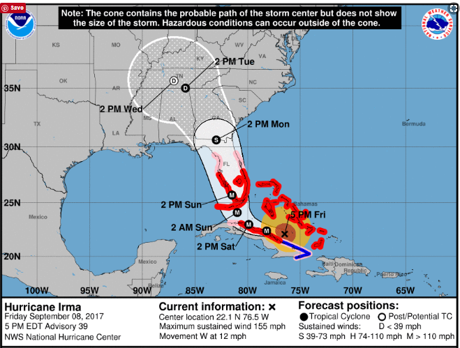
Source: nhc.noaa.gov
As you might be able to tell from the NHC track above, as of yesterday afternoon, the track moved more to the west.  coming in closer to Naples than Miami, and expected to proceed up through the state closer to Tampa than Canaveral.  If that is what actually happens, the Treasure Coast won't get the kind of damage that it would if the track stayed more east.

Now they are concerned about the storm surge that might occur on the Florida west coast.

Our surf predictions have decreased too.

Source: MagicSeaWeed.com
Yesterday they had something like a 22 foot preicted surf, now the biggest is 14 feet.  That is still to occur late Sunday.

Fourteen feet is still a lot more than the two or three feet that we have been getting most of the summer.

If the current MagicSeaWeed predictions are correct, we're not going to get the north winds either now.  Instead they will be east/northeast but mostly east.  That means that not only will the water not be as high into the dunes, but we'll probably get less erosion.  I'm not saying we won't get any.  We almost certainly will get some at various locations.  And it doesn't always take cuts to produce cobs.

After the storm and the east winds pass, we'll quickly be back to south winds - again if the predictions are correct.  That would mean that the beaches would start to refill again.

All of that, of course, is based upon what they think Irma is going to do, which might or might not be correct.  We'll see.

I've heard some say that we won't have much damage to buildings. I wouldn't mind that.  They are saying it will be more of a tree thing.  I won't mind less property damage.  Maybe - just maybe - the damage will be light enough that the beaches won't be closed.  Again, we'll see.

The predicted track could change again, but I don't think it will change much.  The models are agreeing more and the changes seem to be less frequent and drastic.

---

In following Irma I found some good web sites and mentioned them.  Some I posted.

One very interesting thing I found is a traffic app.  Go to googlemaps.com.  From the menu select the "traffic" option.  You will then see a map showing how heavy traffic is on the roads.  That is useful.
One day the Turnpike was jammed and traffic at a crawl or less at a lot of locations. You could take a look at the web site and choose another route if you found one that was moving better.

I saw there was a slow down at a corner near my house, so I went out and looked down the road to see it.  At the time I didn't know how it was done, but I did see the slow moving cars represented by a red line on the map.

You might wonder how google can show the traffic flow for roads all over the state and country.  The answer is they can track people with Android phones and how fast or slow they are moving, and of course they can tell where they are.  That is pretty amazing, but you might not want to think you are being tracked like that.  You don't have to because you can turn off the location data from your phone.

Check it out.  I found it to be a very useful web site.

Before you can do any metal detecting, you have to get there.  You might also like Gas Buddy, which will tell you where they have gas and the price.

---

I received some nice emails from some of the fine and thoughtful people that read this blog.

Thanks to all.

Janine K. sent the following message.

Thinking of all you Floridians and sending thoughts for a safe outcome for all. 

Thanks Janine!

---

Saturday 5 PM Update.

Beach erosion has begun on Fort Pierce beach but the bridges are closed - residents and business owners are among those permitted on the island.

The wind and surf is increasing - mostly from an easterly direction.


Be safe,
TreasureGuide@comcast.net

Friday, September 8, 2017

9/8/17 Report - High Surf, Wind Direction and Dune Erosion. 8 AM NHC Hurricane Irma Update.


Written by the TreasureGuide for the exclusive use of treasurebeachesreport.blogspot.com.

Surf As Predicted by MagicSeaWeed.com Last Evening.

A 22 foot surf would likely bring out some treasure coins even if it isn't from the north or northeast. As I've said many times before, a northeaster is what a lot of people hope for.  And with good reason.

I've explained how waves hitting the beach from the north or northeast slices away sand.  I even once made a YouTube video showing how that works on a small scale.

But a 22 foot surf would result in treasure on the beach no matter what direction the waves were coming from because it would be high enough to hit the back dunes and erode things out of there.

Old coins can come from the dunes or from the surf or from deeper layers of beach sand.  Coins that come from the back dunes could have been in place unmoved for quite a long time and can be in good condition since they haven't been churned in sand and salt water.

Along the Treasure Coast, where you have elevated dunes at the back of the beach, coins and some other objects that are hundreds of years old will typically be a foot or more deep.  That doesn't matter when the face of the dune is eroded because they slide down and onto the beach.

The reason I picked the above surf prediction from MagicSeaWeed is that you see a gradual increase in the surf to a peak, followed by a sharp drop in the size of the surf.  After the surf peaks, it becomes very calm again.

What does that tell you?  Most likely that the wind changed direction.  As the center of a cyclone moving north passes just east of an East Coast beach, first the beach will get hit from the northeast, pushing water onto the beach, but then when the center passes the wind will change and come from the west, pushing the water out and calming the surf.

That is why I thought that image was interesting.  You can see very clearly when the wind changes direction from the size of the surf.

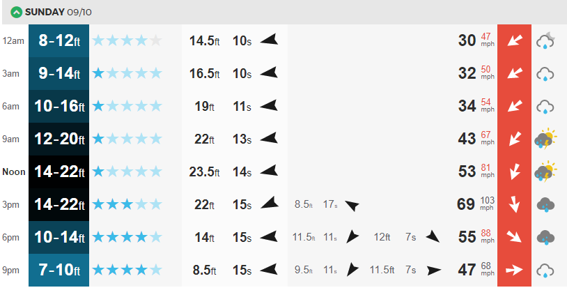
Don't believe me?  Look at this chart from MagicSeaWeed for the same Sunday that shows the 22 foot surf.


Surf and Wind for Sunday, September 10.
You see the peak surf at noon on 9/10.  Over in the red column you see the wind direction.  At first it is northeast.  Then by the peak surf, it is almost directly north.  Then it changes to northwest, and the surf ecreases.  Then the when the wind comes out of the west the surf calms down and becomes much smaller.

I thought that was a good illustration of the correlation between the size of the surf under these conditions and the wind direction.  Of course the correlation is not perfect.  There are other factors to consider, but this is a simple case for illustration purposes.

The north wind, in this case, beside hitting the dunes, will also erode sand from the front of the beach.

When the surf is really high, there won't be much beach that you can detect because of the water.

---

After the 8 AM update, the nhc track has changed very little.  Their track is very much like the Euro model that shows the center coming up near the middle of the state.  The Euro model has the center passing west of Okeechobee, while the GFS model shows the center passing right over Port St. Lucie. We don't know what will actually happen.  The cone still extends from out in the Gulf to out in the Atlantic.

I don't know how many more posts I'll be able to do.

Be safe,
TreasureGuide@comcast.net

Tuesday, September 5, 2017

9/6/17 Report - BIG Surf Predicted for Treasure Coast. Watching for Irma. Updated After 8 and 11 AM advisories.


Writtten by the TreasureGuide for the exclusive use of treasurebeachesreport.blogspot.com.
Predicted Surf for Fort Pierce Area by MagicSeaWeed.com.


It seems to me that the National Hurricane Center has done a good job of predicting the path of hurricanes in recent years.  Still, last year we expected Matthew to hit the Treasure Coast and was surprised that it hit farther north.

We are still days away from the center of Irma and can't tell where it is going to turn.  The National Hurricane Center reminds us not to focus on the exact forecast track, though, especially at the longer ranges, since the average NHC track errors are about 175 and 225 miles at days 4 and 5, respectively. That is a big range.  Some models still have the track going east of us, others to the west of Florida, and some right up the middle of the state.  As a result we know very little at this point other than the fact that there is a still lot of uncertainty concerning where Irma will go.  

From the MagicSeaWeed web site it looks like we will have a big surf.  Above you can see the predicted surf for the Fort Pierce area.  It is big.  Very big.

On Sunday, when the surf is predicted to be near peak, it is also predicted to be from the north.  The beach will be very dangerous.  The beaches might get more eroded than during Francis and Jeane. Still, don't go out there until it is safe. They will probably close the bridges and beaches.  Wait until it is safe.  Think of life and safety first.  Help your neighbor.

In case you haven't found out for yourself yet, a lot of stores are already out of batteries and water.

I've been waiting for some clarity on the likely track of Irma, but haven't got it yet.  It seems to depend a lot upon when it will turn north.  As I said, some models have it going off the east coast, models have it going off the west coast and some models have it going right up through the state.


Position of Irma on Sunday at 5 PM if the GFS model is correct.
Source: Ventusky.com

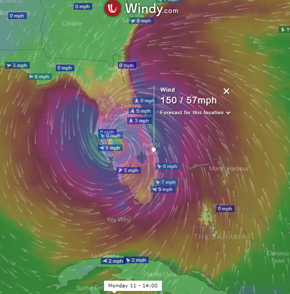
Position of Irma on Monday at 2 PM if the ECMWF model is correct.
Source: Windy.com.
As you can see from the two images above, different models predict different paths.  The GFS model used for the first image is commonly used and is referred to as the American model.  It shows the hurricane heading north, right off of the Treasure Coast.  It wouldn't take much change for it to be right over the Treasure Coast.

Perhaps the most highly regarded model seems to be the European model.  That is shown in the second image, which shows Irma over by Tampa on Monday.

These two models are now a little closer than they have been at other times in the past couple of days, Unfortunately, both of them are very close to us.  

One model has the hurricane moving more quickly than the other.  GFS has it near us on Sunday, while the ECMWF shows the center nearest to us several hours later.

The models are still wiggling around quite a bit.  The next time I look, the results might be very different.  And there are other models showing different tracks.  It is really hard to tell at this point where it might go.


Source: nhc.noaa.gov
This is the National Hurricane Center track as shown after the Sept. 5, 11 PM advisory.  It looks closer to the European model.  

After the 5 AM advisory, they changed the nhc track to go up the middle of the state.  It looks like they are splitting the difference between the European and American models.


New Irma NHC Track After 5 AM Advisory.

After the 8 AM Update, I looked at the GFS and European model and both are now to the east of the Treasure Coast, but the European model is a little closer to the coast than the GFS.  After the 8 AM update, those two models seem to be converging.


Source: wunderground.com
The GFS model is shown above in red.  I snipped this at about 8:30 AM.  The European model isn't one of the ones shown here, but you can see the UKMET model runs right along the coast.   The general trend now seems to be more to the east.  I have no problem with that.
---

11 AM NHC Advisory

The Irma track posted on the NHC web site after the 11 AM advisory is very much like the UKMET model that that you can see in the picture  .  NHC now shows a track moving along the east coast of Florida and very much over the Treasure Coast (below).

Source: nhc.noaa.gov
The new NHC track is closer to the European and GFS models that I showed earlier too.

I hope the eastward trend continues.  I don't want to see the eye-wall going right over us.


Be safe,
TreasureGuide@comcast.net

9/5/17 Report - Still Watching Irma Predictions. Error Coin Web Sites.


Written by the TreasureGuide for the exclusive use of treasurebeachesreport.blogspot.com.


Source: MagicSeaWeed.com.


Here are the MagicSeaWeed surf predictions for Sebastian (above) and Fort Pierce (below).

Both show a pretty big surf for this coming Sunday.  It starts to increase late Friday or early Saturday. 

The predicted peak surf for both locations at this time is above 12 feet.

 Source: MagicSeaWeed.com.


Irma Tracks Shown on WunderGround.com After 2 AM Update.

It seems the predicted paths are trending towards the Florida west coast.  See the tracks as shown on WunderGround.com (above).


Position of Irma as Shown on Windyty.com for 1 PM Monday.
Above is the position of Irma as predicted by running Windyty.com after Irma has passed us.  It ran up along the west coast of Florida.

Below is what you see if you ran the Ventusky web site Monday morning before the 5AM update.

Position of Irma as Predicted by the Ventusky Web Site.

Both the Ventusky and Windyty web sites now show Irma passing to the west of the Treasure Coast.

It is too early to make much out of these predictions.  There is still a lot of time left for changes.

This seems very reminiscent of Matthew, which we watched last year.

---


 For a more pleasant diversion, here are a couple web sites about error coins.

MintErrorNews.com shows an issue of the online magazine.  The sample issue is no. 42.  You can easily find the other issues.

Here is the link.

http://minterrornews.com/issue42.pdf

And below is the link for the error coin section of JimsCoins.com.

http://www.jimscoins.com/error_coin_examples.php

It seems like a long time ago, but a few days ago I posted a picture of what I thought might be a die cap strike nickel.  I haven't seen anything to change my opinion on that but would like to hear from anyone who might have an opinion on that conclusion.

I'll probably update this post some time later today.

Be safe,
TreasureGuide@comcast.net