Thursday, October 6, 2016

10/6/16 Report - Strong Winds Expected Thursday Evening and Friday Morning For Much Of The Florida East Coast.


Written by the TreasureGuide for the exclusive use of treasurebeachesreport.blogspot.com.

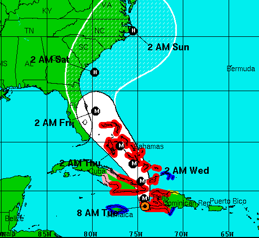
Five Am Update.
Source: nhc.noaa.gov
Here is the five AM update.  Not much change.  Still looks like Matthew will be very close or over land as a major hurricane.  Not much time left for hurricane preparations.  

There were gas stations on the Treasure Coast that were out of gas yesterday.  Governor Scott says we have reserves on supply.

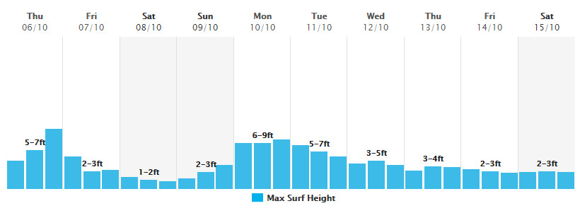
Latest Surf Predictions That I Have.
Source: MagicSeaWeed.com.
You can see that we still have a bump very late Thursday followed by a dip after the hurricane passes.  Then we have a second bump after the weekend.  I told you some of the risks yesterday.  Don't be foolish.

I'll be very busy and may or may not have an interruption in power or internet service.  As a result, I might miss a day or more, but I can't say for sure or when.  

Mandatory evacuation is in effect for many coastal areas along the Treasure Coast.  There will be power outages.

That is all for now.

Be safe,
TreasureGuide@comcast.net

Wednesday, October 5, 2016

10/5/16 Report - Matthew Expected To Head Towards Treasure Coast As A Very Strong Hurricane.


Written by the TreasureGuide for the exclusive use of treasurebeachesreport.blogspot.com.

Water Spout
Photo by Dan B.
This is a great photo of a water spout taken by Dan B. a couple of days ago.  If you look close you can see it coming almost to the ground.

Here is the latest cone.

8 AM Update.
Source: nhc.noaa.gov
As you can see the new predicted track comes very close to us.  It is barely off the coast now.  Other models actually show Matthew coming in and over land around Palm Beach and proceeding inland or up along the coast.  It doesn't look good, and I'm not talking about detecting now, I'm talking about storm damage to the Treasure Coast.  This is a slow moving storm and could cause a lot of damage.

Surf Predictions For The Fort Pierce Area.
Source: MagicSeaWeed.com
The surf charts have changed with the movement of the hurricane, which is a major hurricane, I should add.

If the predictions are accurate we're going to have a big surf Thursday followed by a small surf for a couple of days, and then they are predicting an even bigger surf that lasts a few days.  That means you don't have to get out at the peak of things Thursday, which is a bad idea anyhow.  It looks like there will be plenty of time to get out after things have calmed down a little.  There is no need to run right out in the middle of danger while things are at their worst.  The barrier islands are being evacuated.  There will likely be bridge and causeway closings.  If you are from out of the area, don't run down here to get here while the eye of the hurricane is crossing.

This has changed from something that would simply erode our beaches into a real danger to the entire Treasure Coast.

Windyty.com Screen Shot.
As you can see from the above screen shot, Windyty puts the eye of Matthew very close to us.  This is nothing to be taken lightly.  The eye wall could easily end up passing right over us.

There are two important points I want to make.  First, I want to remind you how dangerous this storm can be.  As a treasure hunter it is easy to think of finds and forget the extreme danger.  No trinket is worth putting yourself or anyone else in danger.   It is that serious.  Maybe you haven't been in a hurricane before or maybe it has been a while so that it isn't fresh in your mind.  Don't get excited and get careless.  Use extreme caution.

Second, don't forget the needs of those around you.  There will be those who elderly, disabled, sick and maybe alone.  There are those who will experience hardship and loss.  The needs of those that need help should come before metal detecting.  This could be a defining time for you.  What are your priorities?  What kind of person are you?

Think about what is really important and what should come first.  That will tell more about your character than any find. I hope you will think about how you can help and who you can help during times like this.  Some people with great finds are plain lousy people.  Another find won't help that.

There are a lot of people that need help under normal circumstances. There will be even more needs if a major hurricane hits our area.  Sorry if you think this is a bit of a downer, but there are more important things in life than silver and gold.


Be safe,
TreasureGuide@comcast.net

Tuesday, October 4, 2016

10/4/16 Report - Hurricane Matthew Predicted Path Moves Closer To The Treasure Coast.


Written by the TreasureGuide for the exclusive use of treasurebeachesreport.blogspot.com.

Cone According To The 8 AM Update.
Source: nhc.noaa.gov
It appears that the drift to the west that I mentioned yesterday is more than a wobble.  The predicted track for Matthew is now closer to the Florida coast than earlier predicted and much of the state is now within the cone of uncertainty.

From what I've seen in the forecasts up to this point, it looks like we'll have north/northeast winds on Thursday, but the strongest wind gusts on Friday, coming out of the west.  I'm hoping the predicted track does not shift any more to the west.  I'd like the track to go back farther to the east.  Some of the models still show it farther east.

74 mph is a level one hurricane. This is a stronger hurricane, and it looks like we'll be getting some pretty high winds.  The ground is already wet.  It still has a couple of days to shift again one way or the other.

Be very careful.  Some bridges, causeways or beach accesses may be closed Thursday or Friday.  You don't want to be on the beach during dangerous conditions anyhow.

Monday Morning Surf Predictions For Fort Pierce
Source: MagicSeaWeed.
Look at that peak surf late Thursday.  That is a big surf and would be when the north/northeast wind is expected.  As the hurricane passes, the wind shifts and we get the west winds and the small surf Friday and through the weekend.

If the predictions are correct, the big surf isn't going to last long but will be big.

Predicted Wind For Thursday Night.
Source: Windyty.com
Here is what the wind will be doing Thursday night according to WindyTy.com.  The center of Matthew will have passed over the eastern Bahamas, and we'll be getting some strong north/northeast winds.  When the storm goes farther north, we'll be getting a west wind.

That is all I have for now.  I might be back later, especially if there is any significant change.

Batten down the hatches.
TreasureGuide@comcast.net

Monday, October 3, 2016

10/3/16 Report - 11 AM Hurricane Matthew Update.


Written by the TreasureGuide for the exclusive use of treasurebeachesreport.blogspot.com.

Monday 11 AM Update.
Source: nhc.noaa.gov
I wanted to do a quick update on Matthew.  The current track takes Matthew a little closer to the Treasure Coast.  There is always a little wobble.  Maybe that is all we are seeing, but it the last few updates does show it coming a little closer to us.  As you can see, although it is getting closer and the cone is narrowing, the western edge of the cone is till touching Florida.

Another thing you might notice is the predictions say that it will take an entire day for Matthew to go from Miami to Melbourne.  That gives it some time to send us some waves.  You can see below that the period of high surf is also spreading out over a longer period of time.  With the slower movement of Matthew, the peak surf is now predicted to be early Friday.

As always, the impact will be in part determined by the wind direction and the tides.

If you missed Part II of my Saturday post about Jupiter, you might want to take a look at that.

I might be back later with some other topics or more updates, but that is all for now.

Happy hunting,
TreasureGuide@comcast.net

Sunday, October 2, 2016

10/2/16 Report - Hurricane and Surf Predictions For The Treasure Coast. Metal Pieces Found On Island Paradise.


Written by the TreasureGuide for the exclusive use of TreasureBeachesReport.blogspot.com.


Beautiful Island Photo
Submitted by Alberto (see below).
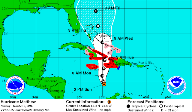
The first thing I want to do today is give an update on Matthew.  The Sunday 2 PM shows the following cone.
Sunday 2 PM Upate
Source: nhc.noaa.gov
There have been a few updates since I last posted a picture of the cone.  There has been little change in the past day or so.

The southern part of the path is a little more to the east than it was. Earlier they had it tracking over a broader area of Cuba.  Now it is just hitting the tip of Haiti and Cuba.  When it gets up by Florida, it staying a little farther east also.  I have no complaint about that.

As far as the strength, it is projected to be above 110 mph until it gets into the northern Bahamas, then it is predicted to weaken a little.

I'm making a lot out of very small changes.  There is still a lot of uncertainty in the whole thing.  Notice that the western edge of the cone of uncertainty still touches the East Coast of Florida.  We'll have to keep watching.

Source: Magic SeaWeed.com.
There are some slight changes in the surf predictions too.  Now Fort Pierce is predicted to get up to 9 feet.  That is less than was predicted the past couple of days, but it is still a good bit.  We'll have to see how it lines up with the tides etc.  I sort of expected these changes.  I've often commented on how big long-range surf predictions tend to moderate as they get closer in time.

Another change, though, is that now we are predicted to get four to six feet for a few days after the peak surf.  That could either help or hurt, depending up on the direction of the wind.  Without looking at that in detail, I'd suspect that it means that cuts will fill in not too long after they happen.  Again, that depends upon the direction of the wind and waves.

---

I got an email  from Alberto S. that included the beautiful photo at the top of the post and the following message.

I have found over time items that look that at some point were pendants etc what I have not been able to figure out is the melted condition I find them in or at least they look like they have melted. One I even found in the San Blas Islands in Panama, while fishing in the area with my brother in law who is from Panama. I could only detect for about 45 minutes near one of the islands because my brother in law was nervous that the Kuna Indians still ruling these islands could get upset. Any feedback would be appreciated. I attached some pics of the items and the island I detected for a brief time. Beautiful place indeed. 

Great photo Alberto!

Here is a another photo Alberto.  This one from a plane.

Photo submitted by Alberto S.
And below are the metal pieces Alberto was asking about.

Pieces of Metal Questioned by Alberto
Photo by Alberto S.
I get a lot of questions about bits of metal like this.  The very smooth shiny ones look like melted aluminum to me.  We get those on the Treasure Coast too.

There are YouTube videos showing aluminum melting in camp fires.

On the Treasure Coast we also occasionally get bits of melted titanium from space vehicles.  Readers have contacted NASA and had that verified.  In my 2/23/13 post you can learn more about that, including tests that will tell you if the metal is titanium.

Some of the other bits look like slag to me.  Slag is a waste product of smelted metals.  I detect pieces like that more up in West Virginia.

I always recommend getting metals that might be either silver, gold or platinum tested by a jeweler or pawn shop of you don't have your own test materials.

Hope that helps.

Keep watching Matthew.
TreasureGuide@comcast.net


Saturday, October 1, 2016

10/1/16 Report (Part II) - More First-Hand Reports Related To The Jupiter Wreck Prior To Its Reported Discovery In 1987.


Written by the TreasureGuide for the exclusive use of TreasureBeachesReport.blogspot.com.

Earlier today I posted about Hurricane Matthew, but recently I've been posting some old finds from Treasure Coast wrecks and camps, especially those found by Darrel S., who hoped that others would also submit their finds so that a more complete record would be obtained to add to our knowledge of the Treasure Coast wrecks.  I know we all like to see finds, but the purpose of posting finds is the larger one of contributing to our knowledge of Treasure Coast history.

Recently I posted a few personal experiences concerning the Jupiter wreck, which is generally accepted to be the San Miguel Archangel.  Subsequently I received some emails related to that subject.  Today I'll post what one archaeologist, Southern Digger, who did a lot of archaeological work around Jupiter, had to say about seeking the Jupiter Wreck in the 1970s.

S. Digger said, After college, I became certified (NASDS) in 1975, and with some research attempted to dive and seek the Jupiter Wreck in 1977. That is when I told the lifeguard about its existence somewhere near the Inlet and he indicated to me that he was planning to search and find it....

S. Digger continued, I was stopped from diving and seeking the wreck in 1977 and was directed to Bessie Dubois who explained it was protected under the Jupiter Inlet Commission and that her husband was on the board. Well she showed me a pile of 4 and 8 Reales and noted when the inlet is dredged and tailings dumped on land,they close the beach and search for cobs.


[I've speculated in this blog about officials closing beaches for private hunting in the past.  TreasureGuide.]

After realizing I would not be allowed to dive and search for the wreck, I was approached by Bessie of the Dubois Historical Society; and the President of Loxahatchee Historical Society; asking if I would help them locate the accurate site of Ft. Jupiter. I was involved in that project for 6 1/2 years, including digs at the battlefield.

Also, between 1979 and 1981 I was considered the archaeologist for their community and was often called off the fort site to assist in investigating other significant archaeological sites in the Jupiter area--some in Dubois Park and near to the lighthouse.


When Hurricane David passed thru Jupiter area in 1979, I inspected the Dragoon camp site which required me to re-clear numerous paths which were initially cut thru the palmettos and scrub oaks with machetes. Then I went to search Jupiter Beach which incidentally, was completely washed out down to hard pan. I found a 10kt gold wedding band, then lost my detector because the saw palmettos at the fort site had sliced into the coaxial wire and at the beach saltwater or rainwater caused the detector to ground out.. Although the instrument box was wrapped and protected, the damaged coil wire caused it to ground out. That was my only reliable beach detector then (Whites Coinmaster VLF Supreme) and I had to send it out for repair. During my brief search at the beach after Hurricane David, I saw no other person with a detector--just surf fishermen.

However, a bit south near the beach restroom, the beach was tunneled and washed out. In the beach was the brown-stained top of a ship-stain from rotted wood and disintegrated iron nails. After further research, I discovered that was the location of the old inlet and a pioneer's schooner was overloaded, grounded and sunk in the inlet sometime during the early 1840's. That is why the Florida Volunteers dug a new inlet at the present location--because the old inlet was no longer passable and it closed up around the foundered schooner. I mentioned this story in my History book on Fort Jupiter.


Thanks for sharing Digger.

I'll add here what Darrel S. said.

As for Jupiter, I go way back and we (surfers) knew of that wreck before the lifeguard story. I know where fill dirt was pulled from dredging in late 1940s to 50s and have found good stuff on properties with permission. Tiger Beach has tons of stuff, but people ignore it...


---

You can find a history of the Jupiter Inlet on the Loxahatchee River History web site (link below).  Here are a few important dates long after Juan Ponce de Leon visited the area in 1513.

1913 to 1922 - The Jupiter Inlet slowly moved to its present location; which is approximately 1250 feet North of its original location.  The inlet would naturally open and close periodically due to the effects of hurricanes and strong storm surge activity over time.

1921 - The Jupiter Inlet District was formed to oversee maintenance, dredging operations, and jetty construction in the Jupiter Inlet.

1922 - The "natural" shoreline of the Jupiter Inlet was changed forever as the Jupiter Inlet District dredged a channel and installed two man-made jetties.

Here is the link for a more complete history.

http://www.loxahatcheeriver.net/History-Jupiter-Inlet-Loxahatchee-River.html

---

My earlier post of today covered Hurricane Matthew and the big surf that is predicted for us next week.

Happy hunting,
TreasureGuide@comcast.net

10/1/16 Report (Part I) - Hurricane Matthew Hit Category 5 Strength. High Surf Predicted for Treasure Coast.


Written by the TreasureGuide for the exclusive use of TreasureBeachesReport.blogspot.com.

Source: nhc.noaa.gov
This is one strong hurricane.  It was for a while a category 5 but fell back to a level 4 last night.

Below is an excerpt form Wikepedia explaining what a category five hurricane is.

The Saffir–Simpson hurricane wind scale (SSHWS), formerly the Saffir–Simpson hurricane scale (SSHS), classifies hurricanes – Western Hemisphere tropical cyclones that exceed the intensities of tropical depressions and tropical storms  – into five categories distinguished by the intensities of their sustained winds. To be classified as a hurricane, a tropical cyclone must have maximum sustained winds of at least 74 mph (33 m/s; 64 kn; 119 km/h) (Category 1). The highest classification in the scale, Category 5 is reserved for storms with winds exceeding 156 mph (70 m/s; 136 kn; 251 km/h).

The list of Category 5 Atlantic hurricanes encompasses 31 tropical cyclones that reached Category 5 strength on the Saffir-Simpson hurricane wind scale within the Atlantic Ocean (north of the equator), Carribean Sea and Gulf of Mexico. Hurricanes of such intensity are somewhat infrequent in the Atlantic basin, occurring only once every three years on average.

Of course the track isn't certain.  It could vary from what is now predicted.  I'm hoping it stays well out in the Atlantic.  I don't want to have to deal with that thing hitting us.  If it does stay on track, we still could get some real big surf.  Below is the surf predication from Magic Seaweed.


Very High Surf Predicted For Treasure Coast Thursday.
That is way bigger than anything we've had for quite a while.  Of course those predictions could change too.

We'll just have to keep watching and hoping we don't have to shutter everything up and tie everything down.

I think I'll have a two part post today.  I have some other things to post but don't want to mix it in with all of this hurricane news.  I might have more for you later today.

For now,

Happy hunting.
TreasureGuide@comcast.net