Written by the TreasureGuide for the exclusive use of treasurebeachesreport.blogspot.com.
 |
Mystery Object
Find and photo by Scott B. |
Here is what Scott said about this find.
I attached a picture of a brass ( maybe bronze?) item I found in some woods near my house in Fernandina Beach. It’s hard to tell from the picture, but it bows out (convex) toward the camera. This convex bend seems to be how it was made, but I might be wrong. The size of the nail holes also varies.
What do you think it is? Send me an email with your ideas.
----
 |
| John Brooks Monday Afternoon. |
I went out to take a look at a few beaches this afternoon. The water had been high on the beach. In fact at Walton Rocks it had been up over the beach and into the parking lot. Despite the high water, I found almost no erosion, and the erosion that I did find was only in renourishment sand. Shells were very scarce too. To sum it up, the South Hutchinson Island beaches that I saw were very sandy.
Above you can see a photo of John Brooks beach. Too bad some idiot kept sticking his finger over the lens.
 |
| Another View of John Brooks Monday Afternoon. |
Notice the pile of weeds that shows where the water stopped.
 |
| John Brooks Beach Monday Afternoon. |
The above photo doesn't show it well, but what I wanted to show with this shot is how far out the waves were breaking. They were breaking 60 or more feet out because of all the sand in front of the beach.
Even though the water was high, there were at least three things that kept the beaches from cutting. One is the angle of the waves. In the above photo you can see that the white water is parallel to the beach. The water was coming right up over the beach instead of slicing away at it.
Second was the amount of sand pile in front of the beach, preventing the beach from much of the water force. The sand in front of the beach also protected any coins that might have been buried there.
The third factor is all of the renourishment sand that has been dumped on the beaches the past few years. Some of it gets washed out, where it protects the front of the beach. That sand will move south, so some of the sand in front of John Brooks probably came from the north where they keep dumping sand and it keeps getting washed away. At other beaches the renourishment covers the front of the dunes so that the older material is not exposed.
DB sent in his observations too. Here is what he said.
Thought I'd check in but looks like you know, it's terrible out there still.
He also said Turtle Trail had been closed for some time and mentioned the millions of wasted dollars going into that project. He continued as follows.
It was pretty funny but sad watching six dump trucks full of sand lined up there two days before a major storm would hit.
Anyhow, it's pretty poor all around, some dunes are cut but like you mentioned it's fill dirt and what I like to call kitty litter.
Hopefully something happens soon,
Thanks DB.
 |
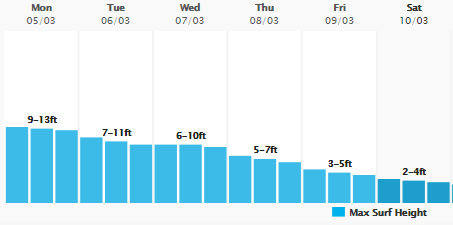
| Source: MagicSeaWeed.com |
As you can see, the surf will start to decrease over the next few days. The wind will switch too. The wind will be coming form the south for a day or so, and then switch again. Then another front will come through and we'll have some north winds again.
People used to talk only about big waves as the thing to watch for. A lot of people now realize that it takes more than just big waves. Angles and other things are important. I've been talking about that in this blog for quite a few years now.
Sometimes the window of opportunity opens for an hour or so and then closes just as quickly. You just have to be there.
It looks like Fort Pierce is turning into a tourist destination. I never saw so many out of state cars down by the jetty. The beach is busy (by Fort Pierce standards ).
Happy hunting,
TreasureGuide@comcast.net