Written by the TreasureGuide for the exclusive use of treasurebeachesreport.blogspot.com
 |
| Small Gold Pendant Find |
As I've been showing, even though conditions have not been good you can still find a few things.
People have been enjoying the fine weather, and that always means there will be lost things.
I wish I could remember the coin to gold ratio that I once calculated for beaches. I had it figured out. The amount of gold relative to coins was much higher for water hunting than beaches. I just wish I could remember the ratios that I had figured out.
The ratio is different from beach to beach, but my number was figured over a number of different types of beaches and over a fairy long period of time, so it was a good general number to go by.
There have been beaches that I hunted and found a good number of coins and knew that I was due for a piece of gold. Other times I'd hit a lot of gold and new that it would average out over time.
Normally a beach that has no coins will not have gold either. Coins are a good sign, but sometimes you have to find a lot of coins before hitting the gold. Of course there are those times when you detect and find no coins but then hit a piece of gold. That is unusual in my experience though.
It is probably not the best time for a poll but I added one anyhow because I wanted to find out what you think. All answers are very much appreciated and will help me to focus the blog. I'd like to get your input, especially as the seasons change and we head into the summer season when storms are the big thing. Please provide your input. And don't forget, you can always send me an email.
When I originally posted the poll I think it got posted twice. They were duplicates. I deleted the second one. At the time there were only 8 and 6 votes. If you were one of the first few respondents you might want to check to be sure your vote didn't get eliminated when I deleted the second copy of the poll.
It has been quite a while since I added any links to my Treasure Site Link List. One link that I have personally been going back to time and time again is the bibliography that I recently posted ( http://uwf.edu/jworth/spanfla_bib.htm). It provides a lot of good links to historical information about Spanish Florida. I just added that link to the list, which you will find to the left of the posts. It is the third item down on the list. If you haven't looked at any of those links lately you might find some interesting links there.
If you go to the bibliography, one journal article that you will be able to access entirely online has the title The Archaeology of Mission Santa Catalina de Guale by David Thomas. In that article can be found the following map showing the locations of the Spanish Missions of Florida in the 17th century.

The test hole system is very much how I approach a beach, except I don't dig a bunch of holes to get a sample, I let my detector tell me where things are. It is still a sampling technique. The point is to do a very lose grid to find out where items of various types are located. When a particular area or areas shows promise, then I will concentrate my efforts on those areas.
Using a sampling will result in misses. That is to be expected. The first step is simply to get some samples. During the first phase, the point is not finding everything. The objective of that phase is to identify areas that show signs that a more concentrated search might be productive.
When an area is identified as having potential, a tight grid can then be used.
Your first sampling doesn't have to cover all areas of the beach. You can eliminate some areas by sight.
In fact sometimes you might be able to narrow down the search area to a fairly small part of the beach just by looking at it. I still do a little sampling before committing to an intense search, not only to see if the spot is as good as it looks, but also to try to determine the boundaries and center of the productive area.
When you get a sense of where things are, including the center and boundaries, of a productive area you can often then tell the best spot for different types of items to be found in that area.
I've talked about that before.
Is it just me, or did the snowbirds start to go home. Yesterday was the lightest traffic that I have seen for a while. One restaurant that has been packed every weekend had less than half the customers. I think they are leaving. I guess the weather has improved up North and it is that time of year.
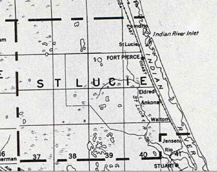
Here is an older map that shows the location of the Fort Pierce inlet before it was at its present location.
I've talked about that in the past. The old inlet was north or Pepper Park. And that is near where the Fort Capron gold coins were found in the water.
This map isn't real old. You can see the railroad is on this one.
On the Treasure Coast the surf is around three or four feet, but will be daily going down to reach a low of only 1 or 2 feet on Wednesday. It will then go back up again the next few days.
The tides have moderated. Not much variation now.
The continuing Southeast winds are not helping at all.
Happy hunting,
TreasureGuide@comcast.net