Wednesday, October 31, 2018

10/31/18 Report - Silver U. S. Coins From Abandoned Resorts and Swimmming Beaches. Indian River County Beaches Opened. Auction Schedule.


Written by the TreasureGuide for the exclusive use of treasurebeachesreport.blogspot.com.

Standing Liberty Quarter.

I was looking at some U.S. silver coins that I dug from various Florida beaches.  There might have been a few from up north, but the vast majority were from Florida.  There are very few of them that are in good condition.  Most are black and have bits of shell attached to them, like the one shown above.  As I looked at them I realized that it isn't easy to find those kinds of coins on Florida beaches, so I thought I'd show a few examples and give a few tips.

First of all, for me they mostly came in bunches.  One day, for example, I visited Jupiter Inlet beach and dug older U. S. coins all afternoon, but hit no reales that day.  The local beach keeper was Dave, who detected there all the time.  He was not happy to see how much I dug that day before he showed up.  I don't know what the coin count was, but it was good.  That was how it often happens.  You are either into the older coins, or not.

Another Beach Dug Standing Liberty Quarter.
The dunes at Jupiter were eroding that day.  I was surprised that no reales showed up even though a lot of silver U. S. coins did show up.

If you want to find these types of coins, you're best chance is at a beach that was used years back - preferably a resort or swimming beach - and then forgotten for some reason.

Some of those old beaches are still used, but your best bet is to find areas that aren't used today.  You can still find some of those that are in out-of-the-way places where you'll have little or no detecting competition.  Believe it or not, there are still places where you will seldom see another detectorist.  Let the crowds flock to the same spots, but if you look around you'll be able to find some places that are can produce but are not heavily detected.  They might be places that seldom produce.  That is why everybody else is not there.

1954 Washington Quarter.
Do your research, find those areas where there were resorts or swimming beaches in the past.  You'll have to check those out-of-the-way places, and they won't produce much most of the time.  You'll have to hit them when conditions are right, otherwise you won't get much.  But once you do find one of those old spots, they'll produce time and time again whenever the conditions are right.

Notice that the 1954 quarter shown above doesn't look any better than the Standing Liberty quarters.  There is a low correlation between the age of the coin and the condition of the coin.

As you can tell, these aren't collector coins.  Most collectors would not be interested in most of them.  That is one problem with beach coins, especially salt water beach coins.  They are seldom in nice condition.

1958 Washington Quarter.
This 1958 quarter is in better condition, even though it is discolored.

Some coins are in great condition under all the encrustation, if you can remove the encrustation without damaging the coin.

These quarters have a melt value of just over $2.50 - not much really, but I always liked digging up things at those forgotten locations just to see what is there.


Unidentifiable Front of a Washington Quarter.  
Same one as above.
I couldn't tell what this one was until I turned it over.

Worn Washington Quarter.

It is a Washington quarter too.

It has a different type of encrustation.  Seems to be more of a clay.  It is well worn.

If you have trouble seeing any details on a coin, sometimes you can see more if you change the lighting.


Crusty Silver Quarter.
When viewed with regular lighting, I couldn't see any detail on the front of this quarter, however when the overhead light was turned off and a light was directed at the coin from the side, I could see part of Washington's profile.

---

Schedule for the Upcoming Sedwick Live Floor Auction.

---

The Indian River County beaches are open now.  Tracking Station beach was delayed due to cleanup.  It seems the Red Tide problem has subsided.

---

Source: MagicSeaWeed.com.
We'll have a three to five foot surf on the Treasure Coast Wednesday and Thursday.


Happy hunting,
TreasureGuide@comcast.net

Tuesday, October 30, 2018

10/30/18 Report - Life On Board a 17th Century Galleon. Serial Number Hunting. Survey Monuments. Hurricane Oscar.


Written by the TreasureGuide for the exclusive use of treasurebeachesreport.blogspot.com.

Survey Monument Near John Brooks Walk-over.
A couple of days ago I was talking about tracking the beach and how it has moved over the years.  In that post I showed a map with the survey monuments marked.  Here is one of those markers at John Brooks, just south of the walkover.

---

I've also been talking about serial number hunting.  Here is a near winner that I got recently in change.


The serial number is 21221912.  If the nine was either a one or a two, the bill would have been worth probably at least ten times the face value.  It would have been what they call a binary.  As it is, it is a tertiary (has three different numbers in the serial number) and still might be worth a little premium.

---

It is easy in this day and age to forget about the people and experience of daily life on board a 17th or 18th century galleon.  It is difficult, if not impossible, to have much of an idea of what it was like.  Below are a couple examples reported by passengers that will give you some idea of the rituals.

The watchglass (sandglass) and the compass box were both maintained with care.

At each half-hour turning of the watchglass, the page on duty calleed out a verse, with words specific to each of the eight turnings in the four-hour shift.

At the first turning, he would say, "Good is what's past,and better what comes; one glass is past and the second is filling; more will be filled if God be willing; to keep the right time makes the voyage fine." 


At nightfall after the evening meal those on board heard the Buenas Noches of the page bringing light to the compass box for the night: "Amen and God give us good night; good voyage, good passage for the ship, sir captain and master and good company."  Then two pages recited the evening prayers: Pater Noster, Ave Maria, Credo, and Salve Regina.  Once finished, the pages on duty went to care for the watchglass, which presumably had been running as usual while the prayers were being said, and recited the nightly blessing; 

Blessed be the hour God came to earth, 
Holy Mary who gave him birth,
and Saint John who saw his worth.

The guard is posted,
The watchglass filling,
We'll have a good voyage,
If God be willing.


On special occasions, there might be quite elaborate religious ceremonies in a fleet, particularly on the capitana and almiranta.  After surviving a thirty-six hour hurricane, one ship returning from the Indies in 1622 held a service of contrition dedicated to Our Lady of Carmen, patroness of mariners.  Everyone on board attended, with the image of the Virgin, adorned with what finery they could salvage, presiding over the gathering from a portable alter on the poop.  The Jesuit chronicler of this voyage led the service, including in his chronicle the long litany to the Virgin recited by those on board, with Latin phrases chanted by the priest answered by the Latin responses from his floating congregation.


For Holy Week, among other great festivals of the church year, crew and passengers participated more fully in the events, although Holy Week would have been rather early for voyages across the Atlantic.  One description of the events noted, 

Since there were religious in the fleet, most of the people confessed, and  on Holy Thursday, with silks and other things that had been brought along, each ship decked itself out in the manner of a monument , displaying images and crosses, and on many ships there were a large number of penitents attending the persons who carried the images.  Holy Saturday at the time of the "Gloria," the capitana first and afterwards the other ships made much rejoicing and fired all their heavy and light artillery, so much that it was quite something to see.  Easter Sunday, in the morning, all the ships, led by the almiranta, went to salute the capitana, which displayed its many flags and banners, and they saluted her with much artillery.  The capitana returned the salute of the almiranta with seven or eight pieces of heavy artillery and with music and trumpets and other instruments returning the salutes of the other shipwswith music alone.


The above excerpts in blue were taken from Six Galleons for the King of Spain by Carla Rahn Phillips.

---

Oscar is now a hurricane but is out in the middle of the Atlantic and headed away from us.

The surf will build Wednesday then start decreasing again Thursday.


Source: MagicSeaWeed.com.

Happy hunting,
TreasureGuide@comcast.net

Monday, October 29, 2018

10/29/18 Report - Eerie Eelie Beach. Some Small Erosion. Not Kang Hsi, Oxidation on Nice Mercury Dime.


Written by the TreasureGuide for the exclusive use of treasurebeachesreport.blogspot.com.

John Brooks Beach Sunday Afternoon.
The surf wasn't large but the wind direction was good so I went out to take a look at the beaches yesterday.  Often when a front comes through you'll get a little cutting.  As you can see from the photo above, there was a little erosion.  The surf and tides were high, so the cut was low on the slope. The sand in front of the slope was fairly soft.

The weather was beautiful, and on such a beautiful Sunday afternoon, you'd expect to see a lot of people, but there were very few people at the beach.  Evidently the Red Tide was still keeping people away.

I felt a little respiratory irritation, but not as much as at Jensen Beach a couple days ago.  There were a few dead fish and eels.  


I didn't know there were eels in the lagoon until the I saw some dead ones over there recently.

John Brooks Beach Sunday Afternoon.
Notice how the water is washing up onto the beach here was at about a thirty degree angle.  That was directly below a cut and was the cause of the cut.  

Frederick Douglass Beach Sunday Afternoon.
Above is the view looking south from Frederick Douglass beach.  As you can see there was less erosion there.  The depth of the foot prints also shows you that the sand was soft there.

Fort Pierce South Jetty Beach Sunday Afternoon.
There was a nice cut south of the Fort Pierce Jetty.  Unfortunately that is all renourishment sand.  

Notice the steep slope in front of the cut in the distance.  That is down near the old picked-over wreck.

For such a beautiful day, it is a shame that people weren't able to enjoy it more.

---


Blue and White Beach Shard.
If you were walking the beach and found this shard, at first glance you might think Kang Hsi.  If you've seen much Kang Hsi, a closer look will show that it is something else. Take a look at the broken edge.

Edge of Shard.

The paste is not as white and fine as Kang Hsi.  This paste is more coarse and not as hard.  But that isn't all.  The top layer of blue sits on top of the surface.  Kang Hsi has a transparent layer and the blue penetrates down through that layer.  I think I've shown that before.

---

1942 Mercury Dime.
This is an old find that I decided to experiment with.  I'm experimenting with methods of removing the black oxidation.

Close View of Oxidation.
This dime was probably in excellent shape when it was lost.  The date and lettering is still very nice.

It is very rare to find a nice silver coin on a salt water beach that isn't badly damaged.

--

We'll have some more north wind, but the surf won't pick up until late Tuesday.

Happy hunting,
TreasureGuide@comcast.net


Sunday, October 28, 2018

10/28/18 Report - Valuable Paper Money in Circulation. Watch For Cleaned Coins. Erosion in North Florida. Old Ship Found.


Written by the TreasureGuide for the exclusive use of treasurebeachesreport.blogspot.com.

Dug Corroded Partly Cleaned Penny.
I just cleaned a load of old corroded coins.  I tried a new experimental procedure that didn't work out real well.  I wouldn't recommend the process, but I sort of like the look of the coins.

You can often tell when you get somebody's dug coins in change.  I'm going to put a number of these in circulation, and am showing you with the hope that you'll tell me if you get one.  I know I'll recognize them if I get them back.  They all are banged up and corroded, having spent time in the surf.  They have a dark background scuffed bright high design features.


---
Erosion in St. Augustine Area
Photo by Bruce B.
Bruce B. said the beaches in the St. Augustine area are losing a lot of sand and provided the photo above.

There is always some place to detect.  Some spots are better than others.  If you look around enough you can usually find a decent spot.

There is a tropical storm in the Atlantic: Oscar.  Below is Oscar's predicted track.

Tropical Storm Oscar.
Source: MagicSeaWeed.com
Oscar will, however affect us to some extent.


Wednesday Wind Predictions.
Source: Ventusky.com
You can see the north wind that we'll get Wednesday, when the Treasure Coast surf will increase.


---

I've been enjoying checking the serial numbers of the paper money that I receive in change.  It is possible to receive a bill worth hundreds of dollars.  Many are worth less than that but more than the face value.

It is an entertaining activity with the possibility of profit something like playing the lottery but without the cost.  All you have to do is check.

Here are a couple web sites that describe serial numbers that might be worth something.

https://www.dailymail.co.uk/news/article-2423315/Dollar-Serial-numbers-make-banknotes-worth-thousands-online-trend.html

This one will give you some idea of the value of bills with various serial numbers.

http://coolserialnumbers.com/ForSale.aspx

---

A centuries-old ship was found by archaeologists.
The finds include parts of a merchant vessel, a cog, dating back to the 13th century, as well as some imported German and Danish ceramics, possibly brought to Sweden on the same ship.
Here is the link for the articles and photos.

https://www.thelocal.se/20181024/archaeologists-find-medieval-ship-and-german-ceramics-in-enkping

---

The weather is beautiful.  Just judging from the northeast wind that I see outside, I think you might be able to find some small cuts.

Happy hunting,
TreasureGuide@comcast.net


Saturday, October 27, 2018

10/27/18 Report - On Moving Beaches: More Illustrations. Yosemite Tragedy.


Written by the TreasureGuide for the exclusive use of treasurebeachesreport.blogspot.com.

Old and New Photos of The North Fort Pierce Causeway Area.
Submitted by Dave J.
People often talk about how items sink and get moved on a beach.  Movement is a relative thing.

Beaches are dynamic.  Beach sand moves a lotHow the sand moves is often more important than how other items move.  That is often missed.

People often think that when an item or wreck suddenly shows up on a beach that it was washed up and when an item disappears, it sank.  Fact is that just as often the item moved little or not at all, but the sand moved.

Yesterday I was talking about how the sand moves and showed the Fort Pierce inlet area as one example.  Dave J. got what I was saying and did some research on his own.  He sent the above pictures of the area just north of the inlet for comparison.

Dave said, I was just looking at the FP inlet and used some old 1948, 1958 pictures of the corner at north causeway and A1A. Attached is old vs new and looks like an entirely new parcel of land was created (red outline). 

Thanks Dave! That is a great illustration.  

As I said yesterday, the area to the north of the inlet is an area of accretion, while the beach to the south of the inlet tends to erode.  That means that items to the north of the inlet will tend to get covered, while items to the south will get exposed when the sand erodes.

New discoveries are often made south of inlets where the natural flow of sand is interrupted, while older items to the north get covered.  That is on the west coast where the prevailing long shore currents are north to south.

If you want to buy beach front property, you might want to think about an area to the north where the beach will increase, instead of in an area where the beach will be disappearing.

Here is another look at the photo I posted yesterday.

Fort Pierce Inlet.
Compare that with the picture of the Jupiter Inlet (below).

Jupiter Inlet.
Notice the similarity.  Notice how much more narrow the beach is towards the top of the photo.  That is not all perspective.

Once again, the beach to the south of the inlet would be even farther back if it wasn't for all of the beach renourishment projects.

If the Jupiter wreck scattered to the north, it could now be under the accreted sand.

---


This photo of a couple on a high ledge at Yosemite is real.  It looks like fantasy art, but it is not.  Yosemite has the most dramatic scenery of anywhere that I have been, and I'd recommend it to everyone, at least once.

Here is a link to a story about that.   Unfortunately a couple taking a selfie fell off.

https://sanfrancisco.cbslocal.com/2018/10/25/couple-fatal-fall-yosemite-parks-taft-point/

Many years ago I hiked up a trail that got VERY narrow and looked straight down hundreds of feet.  It was too much for me, and I turned around and went back down.  Once I got to the trail head, I looked back and saw a sign at the entrance that said, Trail Closed - Falling Rocks.  Didn't matter to me, because it was way too high and the path on the ledge way to narrow even if it was stable as the Rock of Gibraltar.

---

The tides on the Treasure Coast are nice and high.  There is a beautiful full moon.

There won't be any big surf for a while.

Happy hunting,
TreasureGuide@comcast.net

Friday, October 26, 2018

10/26/18 Report - Where Is The Treasure Now? One Thing You Should Know. Red Tide in Vero.


Written by the TreasureGuide for the exclusive use of treasurebeachesreport.blogspot.com.

Fort Pierce Inlet.
Snipped from Floridadep.gov.  Full link below.

I mentioned a project to find gold bars dropped along a West Coast beach a few decades ago.   The bars were scattered to some extent.  Those hunting the bars have a general description of where the bars were dropped (scattered)  relative to the beach and a delta.

Since the bars were dropped a few decades ago, the first thing I'd want to know is where the shoreline was when the bars were dropped relative to where the shoreline is now.  Beaches change over time and it is important to know where the beach was relative to where it is now.  That is often an overlooked and very important piece of information.

Let's just say the bars were said to be dropped along the shoreline very close to the water.  Where was the water line at that time?  Was it farther out than it is now, or is it now under the beach.

If we use the Fort Pierce inlet area as an example, we know that north of the inlet the sand has been accumulating for quite some time, and the shoreline just south of the inlet continually erodes.  The shoreline to the north of the inlet has been moving one way, while the shoreline south of the inlet has been moving the other.  If the bars were dropped along the waterline, if they were dropped north of the inlet a few decades ago, they would probably be under the beach now.

Fortunately there is good detailed data on shoreline changes.  For Florida you can find very detailed data for most of the 20th and 21st century.  If you do the research you can find out where  the beach was back some years ago and compare that with where the beach is now.

If you were told that a bar was buried ten yards back from the water line fifty yards south of the Fort Pierce inlet fifty years ago, it might seem like you'd have a good idea of where that bar was.   However, the shoreline might have changed a lot in those fifty years.   In recent years the beach just south of the inlet changes a hundred yards east/west every year or two when they renourish the beach and then it erodes again.  You can't just go out to the waterline and march back fifty yards and figure that is where the bar is.

It doesn't have to be bars of gold.  Resort beaches have changed the same way.  One beach that I hunted a lot in the past is now covered by at least a hundred yards of new sand.  The beach and dips in front of that beach that I worked thirty years ago are now deeply buried, as are the items dropped there back then.  It helps a lot to know where the beach was compared to where it is now.

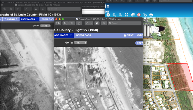
Below is an example of a map that shows how erosion changed a shoreline between 1954 to some time in the 2000s.  If there was a swimming beach at this location in the 1950s hundreds of yards farther out than they would be most recently.  Or if there was a shipwreck offshore, it would now be much farther out from shore.

Map Showing How a Shoreline Changed Over a Few Decades.

There will be daily, monthly, yearly changes, but there are also fluctuations that occur over decades and centuries.   A shipwreck that was in the water could now be under the beach if it is in an area where there is accretion rather than erosion.

Florida provides an immense amount of shoreline data.  The database is not easy to use unless you are familiar with it, but the information is there if you are willing to do the hard work.

Here is a link to the Florida shoreline database.

https://floridadep.gov/water/beaches/content/historic-shoreline-database

If you take the time to dig into it, you'll be amazed at the detail that is available.  There is map, survey and photographic documentation on virtually every foot of shoreline.

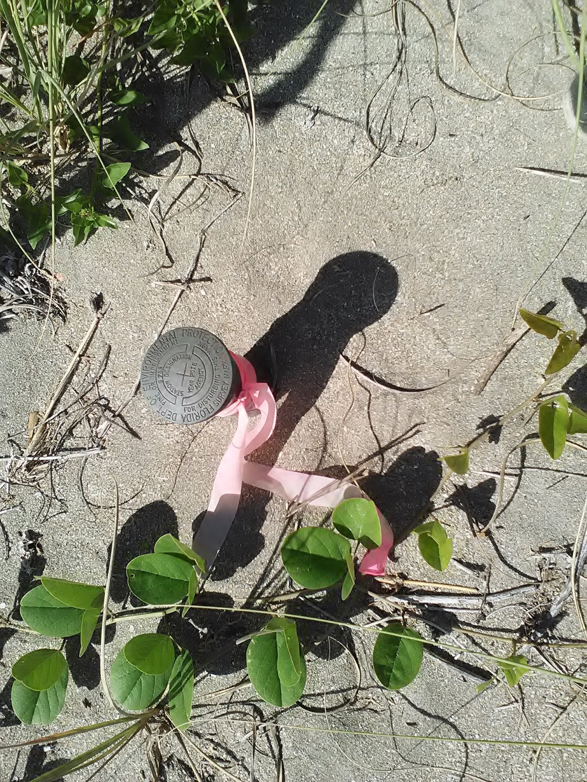
If you look at the photo at the top of the post, you'll see that there are six small red triangles west of the shoreline.  Those are the survey monuments.

The Florida Public Land Survey System (FLPLSS) was established by the United States Government Land Office (GLO, now re-organized under the Department of the Interior, Bureau of Land Management, BLM) beginning in 1824, with the establishment of the Initial Point in Tallahassee. This system of rectangular survey grids was gradually extended through the remainder of the 1800's eventually covering the entire state, dividing all the public lands first into six mile by six mile areas (Townships), then subdividing these Townships into one mile by one mile regions (Sections). Physical survey markers, or monuments, were placed every half mile on these section lines to delineate the surveyed lands. Monuments were also placed at points on the section lines where they intersected bodies of water or previously occupied (private) lands...

(Source: http://sfrc.ufl.edu/pdf/faculty/gibsonresearch.pdf)

I better wrap this up.  If you have a general description of the location of a beach treasure, the first thing you might want to do is check to see how the beach has changed since the time of the description.  It seems that people don't appreciate how much or how rapidly beaches change.  You will want to know where the beach is now compared to where it was in the past.

Shipwrecks that were once underwater can now be under sand.  Treasures that were once buried on the beach, can not be out in the water.  People talk a lot about how items move, but beaches move too.  The movement of the beach is just as or more important than the movement of the items.  A lot of data is available if you are willing to dig it out.

--

There is a lot more to be said on the above topic.  I might pick up on it again real soon.

One reason I chose the picture at the top of the post is that it is not a simple case.  It is more complex than an unbroken stretch of beach.  See if you can see how the sand is flowing at various spots.

---

I've noticed that more people are starting to use DuckDuckGo.
DuckDuckGo says, DuckDuckGo is an Internet privacy company that empowers you to seamlessly take control of your personal information online, without any tradeoffs. With our roots as the search engine that doesn’t track you, we’ve expanded what we do to protect you no matter where the Internet takes you.

See DuckDuckGo.com.

---

It seems that the Indian River beaches have some of the most toxic Red Tide contamination.


---

Happy hunting,
TreasureGuide@comcast.net

Thursday, October 25, 2018

10/25/18 Report - Red Tide Keeps People Off Treasure Coast Beaches. Gold Relic. Most Active Hurricane Season Ever.


Written by the TreasureGuide for the exclusive use of treasurebeachesreport.blogspot.com.

Flag Indicating Red Tide Spores Displayed at Jensen Beach Yesterday.

Red Tide was strong at Jensen Beach yesterday afternoon.  It evidently kept a lot of people off the beach, but there were a few there.   I heard a lot of coughing and saw one kid crying with burning eyes.  It can be serious.  Too bad!  It is otherwise beautiful beach weather.

Jensen Beach Yesterday Afternoon.

There were more people to the north for some reason.

The beach had lost some sand.  You can see the small cut and the slope had eroded back some.  You can also see a small dip in front of the beach.  Didn't look half bad for modern jewelry if the Red Tide doesn't bother you.

Jensen Beach Yesterday Afternoon.
It looked like the tide predictions were pretty accurate.  Just some small waves breaking on the sand bar at low tide.

Expect nothing more than a two or three foot surf for the next few days.

We have a full moon and some decent tides.

---

Gold Relic.
Source: See MSN.com link below.


The origin of a mysterious golden relic has been identified after leaving archaeologists baffled for almost 150 years.
The small, flat golden plate was uncovered alongside a female skeleton and a coin at a grave site beneath York station in 1872...
The coin, which was made of copper with a silver wash over the top, had the face of Septimius Severus on one side and Fortuna, the goddess of luck on the other.
Severus was Roman Emperor from 193 until his death in York in 211, but it is not clear whether the woman was buried during this period or later...
Here is the link.

https://www.msn.com/en-us/news/world/mysterious-gold-relic-finally-identified-after-baffling-scientists-for-almost-150-years/ar-BBOOO67?ocid=spartandhp

---

The oceans near North America have been angry this year.


When all the hurricanes and tropical storms that have formed in the Atlantic and eastern Pacific Oceans this year are added together, the 2018 hurricane season is the most active season ever recorded, Colorado State University meteorologist Phil Klotzbach announced Tuesday...

Here is the link for more about that.


https://www.usatoday.com/story/news/nation/2018/10/23/hurricane-season-most-active-record-atlantic-pacific-combined/1741226002/

----

I was consulting with a treasure author that was wondering about how far some bars of gold might sink into the sand over a period of a few decades.  I won't give any details because I don't want to put anybody else on the trail, but some bars got deposited in a fairly unusual way and they wanted to try to find them.  It took me a couple of emails to answer, but I still wasn't happy with the answer.  That reminded me that I started to talk about the subject of how things sink in the sand a few weeks ago in this blog.  I introduced a question, but got off on other subjects and failed to answer the question.  I'll try to do that some day soon.  I'll have a meaty related subject for you tomorrow.


Go, and do well.
TreasureGuide@comcast.net