Showing posts with label track. Show all posts

Friday, August 30, 2019

8/30/19 Report - 3 PM Update and 5 PM Update - Change to ECMWF Model.


3 PM Update.

The weather channel just announced a change to the ECMWF track.  The new change took the track of Dorian up along the East Coast without coming onshore in Central Florida.  I'd be happy with that. 

The National Hurricane Center map has not changed the cone yet. 

At the time of this update, the GFS track was heading up towards the Space Coast. 

---

At 5 PM the weather channel once again showed the track of the European model that keeps Dorian just off-shore.  They did however mention that are still models that take it directly into the state.

Also the latest National Hurricane Center cone has now changed a bit.  It now has the center of Dorian making landfall right over the Fort Pierce Inlet and then turning north.

Center of National Hurricane Center Cone.
Source: nhc.noaa.gov
The past few National Hurricane Center updates seem to show a trend of the track moving more to the north and east.

Unfortunately there is still a lot of uncertainty on this one.  The spaghetti models are still all over the place.

Stay tuned.


---

Thursday, September 7, 2017

9/7/17 Report - Hurricane Irma Predictions. Dangers and Difficulties of Detecting a Beach After a Hurricane.


Written by the Treasureguide for the exclusive use of treasurebeachesreport.blogspot.com.

Track of Irma So Far
Source: Wunderground.com
Above you can see the curvy track of Irma.

Below is the cone from NHC after the 5 AM advisory.  That track takes the eye right over Fort Pierce and the Treasure Coast.  It will still be a very strong hurricane.


NHC Cone After 5 AM Advisory.
Source: nhc.noaa.gov

Of course, there isn't 100% certainty of the future track.  

Probability of Tropical Storm Force Winds.
Source: nhc.noaa.gov
Above you can see the probability of tropical-storm-force winds hitting the Treasure Coast.  It shows that at the time of the prediction, there was a 80 - 90 percent chance that the Treasure Coast would receive tropical-storm-force winds.  The probability of hurricane-force winds, as estimated at about the same time, was less than 50 percent.

The point of that is that there is still uncertainty about the track of Irma.  Although both the Euro and FGS models are very similar now and have the eye-wall passing over or very close to Fort Pierce, it could vary.  As you can see above, the cone still extended well out into the Gulf and into the Atlantic, so it still could end up going right over us or into the Gulf or out in the Atlantic.  I really don't want the eye-wall over us or real close to us.

---

I've heard from detectorists from out of state that want to run down to the Treasure Coast on Sunday and do a little detecting.  That could be a very serious mistake.  HURRICANES ARE VERY DANGEROUS.   Hurricanes kill people and cause serious damage and real human suffering. 

I can tell you right now that I will not be out there Sunday. I will be taking care of people who need assistance.  I probably wouldn't be out there Sunday even if I didn't have those other responsibilities. There will likely be many people who really need some assistance.

When the storm passes, unless it passes way off the present predicted course, things will be a mess. There is likely to be downed trees and power  lines across the road.  People will be coming out and looking at the damage and wondering how they are going to go on.  Beach accesses will be closed. Roads and bridges will be closed.  Roads might be flooded or washed away.  You might not be able to get where you want to go.

There could be massive power outages.  Gas stations could be closed.  And authorities won't want you out on the road to get in the way of emergency efforts.

It is easy to get excited hearing about gold coins on the beach, but hurricanes are dangerous and not totally predictable.  There might be good detecting or there might not.    Last year,  Matthew didn't hit where they thought it would.   

This will be especially tricky because there are three hurricanes out there.  Hurricane Jose is following closely after Irma, so after Irma passes and everything looks bright and sunny, you might just encounter Jose.

If the beaches are badly damaged, it probably won't be easy to get there, and when you do, you'll encounter other dangers. The high surf could be very dangerous.  After a hurricane, the surf contains a lot of debris.  Anybody who has been on the beach immediately after a hurricane, probably has a story about nearly getting taken out by a tree trunk thrashing around at the edge of the water.  The backwash coming off the dunes can be powerful and dangerous.  It doesn't take a hurricane to cause that.  It can easily catch you off guard and knock you off your feet and sweep you out.  I know of more than one person who has lost a metal detector or other equipment to a rough surf.  

I'm especially concerned about people who have never been through a hurricane and unknowingly putting themselves at risk.  There are many dangers, and you might not know about the dangers or what you are getting yourself into.

In short, I want you to realize that hurricanes are dangerous and that you should not think of trying to face the storm winds or the dangerous surf after a hurricane for a few coins.  I don't want anyone to run out to the beach not knowing what they are getting into and getting hurt or worse.  I'd rather you volunteer to help with the recovery efforts.  I know I'm being a downer right now, but I want you to realize the very real danger.   If you want golden memory for the rest of your life, volunteer and help people who need it.

Another thing people don't realize is that hurricane ravaged beaches can produce for days or even weeks after the hurricane passes.  Some of the most amazing finds have been made when the detectorist thought it was too late to find much of anything.  Be sure that conditions are safe and you are prepared before you even think about running out to the beach to find some coins.

Be safe,
TreasureGuide@comcast.net

Tuesday, September 5, 2017

9/6/17 Report - BIG Surf Predicted for Treasure Coast. Watching for Irma. Updated After 8 and 11 AM advisories.


Writtten by the TreasureGuide for the exclusive use of treasurebeachesreport.blogspot.com.
Predicted Surf for Fort Pierce Area by MagicSeaWeed.com.


It seems to me that the National Hurricane Center has done a good job of predicting the path of hurricanes in recent years.  Still, last year we expected Matthew to hit the Treasure Coast and was surprised that it hit farther north.

We are still days away from the center of Irma and can't tell where it is going to turn.  The National Hurricane Center reminds us not to focus on the exact forecast track, though, especially at the longer ranges, since the average NHC track errors are about 175 and 225 miles at days 4 and 5, respectively. That is a big range.  Some models still have the track going east of us, others to the west of Florida, and some right up the middle of the state.  As a result we know very little at this point other than the fact that there is a still lot of uncertainty concerning where Irma will go.  

From the MagicSeaWeed web site it looks like we will have a big surf.  Above you can see the predicted surf for the Fort Pierce area.  It is big.  Very big.

On Sunday, when the surf is predicted to be near peak, it is also predicted to be from the north.  The beach will be very dangerous.  The beaches might get more eroded than during Francis and Jeane. Still, don't go out there until it is safe. They will probably close the bridges and beaches.  Wait until it is safe.  Think of life and safety first.  Help your neighbor.

In case you haven't found out for yourself yet, a lot of stores are already out of batteries and water.

I've been waiting for some clarity on the likely track of Irma, but haven't got it yet.  It seems to depend a lot upon when it will turn north.  As I said, some models have it going off the east coast, models have it going off the west coast and some models have it going right up through the state.


Position of Irma on Sunday at 5 PM if the GFS model is correct.
Source: Ventusky.com

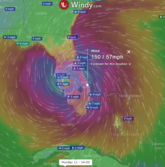
Position of Irma on Monday at 2 PM if the ECMWF model is correct.
Source: Windy.com.
As you can see from the two images above, different models predict different paths.  The GFS model used for the first image is commonly used and is referred to as the American model.  It shows the hurricane heading north, right off of the Treasure Coast.  It wouldn't take much change for it to be right over the Treasure Coast.

Perhaps the most highly regarded model seems to be the European model.  That is shown in the second image, which shows Irma over by Tampa on Monday.

These two models are now a little closer than they have been at other times in the past couple of days, Unfortunately, both of them are very close to us.  

One model has the hurricane moving more quickly than the other.  GFS has it near us on Sunday, while the ECMWF shows the center nearest to us several hours later.

The models are still wiggling around quite a bit.  The next time I look, the results might be very different.  And there are other models showing different tracks.  It is really hard to tell at this point where it might go.


Source: nhc.noaa.gov
This is the National Hurricane Center track as shown after the Sept. 5, 11 PM advisory.  It looks closer to the European model.  

After the 5 AM advisory, they changed the nhc track to go up the middle of the state.  It looks like they are splitting the difference between the European and American models.


New Irma NHC Track After 5 AM Advisory.

After the 8 AM Update, I looked at the GFS and European model and both are now to the east of the Treasure Coast, but the European model is a little closer to the coast than the GFS.  After the 8 AM update, those two models seem to be converging.


Source: wunderground.com
The GFS model is shown above in red.  I snipped this at about 8:30 AM.  The European model isn't one of the ones shown here, but you can see the UKMET model runs right along the coast.   The general trend now seems to be more to the east.  I have no problem with that.
---

11 AM NHC Advisory

The Irma track posted on the NHC web site after the 11 AM advisory is very much like the UKMET model that that you can see in the picture  .  NHC now shows a track moving along the east coast of Florida and very much over the Treasure Coast (below).

Source: nhc.noaa.gov
The new NHC track is closer to the European and GFS models that I showed earlier too.

I hope the eastward trend continues.  I don't want to see the eye-wall going right over us.


Be safe,
TreasureGuide@comcast.net

Wednesday, August 26, 2015

8/26/15 Report - Erika Headed Towards Florida, Lima 8-escudo, Treasure Crates, Smuggling and Contraband, New Wreck Discovered

Written by the TreasureGuide for the exclusive use of treasurebeachesreport.blogspot.com.


Predicted Path of Erika.
Source: nhc.noaa.gov
Erika looks to be headed towards Palm Beach and is expected to arrive very early Monday as a level 1 hurricane.  There are still a few days for all of that to change, so keep watching.

The surfing web sites are not predicting a big increase in surf. They are only showing a maximum of four feet on Sunday evening, decreasing after that.

It is still too early to be certain.  That could change as well.

I'd really like to see some sand get removed.  I'd so like to see a ripped beach.  It has been so long.

---

1702 Lima 8-Escudo
Photo submitted by Captain Jonah Martinez.

Here is an interesting escudo.  Notice how the top of the pillars is off angle.

---

The other day I was talking about how treasure was packaged on the treasure fleets.  I found the following in the Foster article on Talegas and Contraband.


Here is that link again.

 http://www.academia.edu/9270986/Talegas_and_Hoards_The_Archaeological_Signature_of_Contraband_on_a_1725_Spanish_Merchant_Vessel

The chests weren't always cedar, and they weren't always of exactly the same dimensions, but it seems they were usually pretty similar.   Since gold is nearly twice as dense as silver, I'd assume that crates carrying gold weighed closer to 450 pounds.

---

There is a lot of really good information on the internet these days. Here are a couple of books that I found.

One is Smuggling: Contraband and Corruption in World History by Alan Karras.

Click here to link to that book.    Click on View Sample when you get there to read the sample.

Looks like a very interesting book.

---

 Here is another book you might like to take a look at.  It is  Treasures of the Spanish Main: Shipwrecked Galleons in the New World by John Chistopher Fine.

You can read a sample of that one online too.  The sample had some nice information on the 1715 Fleet.

Click here to link to that.

---

(August 24, 2015) - During the repair of the US 50 Bridge over the Nanticoke River, the Maryland Department of Transportation’s State Highway Administration (SHA) discovered an 18th century shipwreck in the water. SHA was removing debris from under the bridge when workers realized some of the wood may be ship timbers...

Here is that link.

http://www.roads.maryland.gov/Pages/release.aspx?newsId=2332

---

Keep watching Erika.

Happy hunting,
TreasureGuide@comcast.net