Showing posts with label accretion. Show all posts

Tuesday, February 4, 2020

2/4/20 Report - Monitoring Cleaning of Silver Reale. Beach Conditions: Short Term and Long Term.


Written by the TreasureGuide for the exclusive use of treasurebeachesreport.blogspot.com.

Four Reale After Cleaning and A Little Polishing.
I've been showing the progress as I clean a recently found four-reale.  I showed a few photos of that previously, including how it looked when it was found and how it looked after a little cleaning.

I cleaned that cob some more, and you can see above how it looks now.  I'm done with the Muriatic acid.  The encrustation has been removed, and I did just a little shining with a baking soda paste.

The details can be seen much better now.  I'm pretty sure that it is a Phillip V and dates to between 1700 and 1715.

Below is a close-up like the one I showed just a few days ago when I was not done with the cleaning.  If you compare this photo with the one I posted the other day, you'll see how much of the encrustation and foreign particles have  been removed by soaking in Muriatic acid.  You can also see how the high areas that have been shined actually look like silver now.

Close-up View of Part of the Same Four-Reale.

I also stumbled onto something else that might be helpful.  If you want to get a better look at the design before you are done cleaning it, you can use some wet baking soda spread thinly across the surface of the cob to bring out the design, as shown below.


Same Four-Reale With Baking
Soda Bringing Out the Detail.

With just the naked eye I could see the details of the design probably better than I could see it with magnification but without the contrasting white substance.  I was really surprised by how much it helped.  I took the above photo with a regular digital camera.  I probably should have used magnification so you could see the effect even better.

---

Steve and Paulette M. sent the following email and photos take yesterday (2/3) and commented on Bonsteel where the cliff in front of the dunes is about six feet high.  Below is the photo and email.

Bonsteel Park 2/3
Photo by Steve and Paulette M.
Today we were looking at different beach accesses north of Fort Pierce and we started at Indialantic and went South to Turtle trails.  Not much good looking erosion anywhere.  We went to Bonsteel knowing 3 weeks ago they dumped sand and bulldozed it a quarter mile north and south about 6 feet thick.  Today it was just about all gone.  Just a thin slice at the dune.  Beach was wider, but not too much. Steve and Paulette M.

Bonsteel Park 2/3
Photo by Steve and Paulette M.
Thanks Steve and Paulette.

---

Yesterday I posted a link to an article that discussed a method of monitoring long term beach trends of accretion and erosion.  You'll find that it provides some interesting clues.

Long term trends are obviously important to the treasure hunter.  A beach that has been building for decades will have a lot of sand covering up many of the kinds of things you would most be ooking for.  It can take a lot more to uncover treasure at a beach that has a lot of accumulated sand.

A beach that has generally been eroding over the years and decades, on the other hand, will give you a much better chance.  Although it will vary one way and then the other on a shorter term basis, it won't take as much to uncover the old stuff.

One Treasure Coast beach that was very productive back in the 80s and 90s has been much less productive in the past few years due primarily to frequent renourishment programs to the north and littoral drift.

The sand dumped by renourishment projects will generally eroded much faster than sand that has naturally accumulated.  For one thing it is out of place.  No matter how many hundreds of yards is renourished, it will normally be bordered by areas were the sand has been depleted.  That makes the renourished areas more vulnerable.

No matter how often they dump sand at places like the beach south of the jetty at Fort Pierce, it will erode very quickly because of the interruption of sand caused by the inlet and jetty.

If a beach has been generally eroding over a period of time, new sand dumped on the area will not normally last long very long, but has a slightly better chance if it is dumped during the spring or summer when at least the short term trend is more favorable.  Of course a strong storm could change all of that.

One thing to keep track of is the long term trend of the beach.  Has it been eroding, building or staying about the same?  The bottom line is that a beach that has been eroding over the years will tend to become productive more easily and frequently than one that has been building over a long period of time.

---

The surf is small and the tides are small.  In a few days the surf is predicted to increase up to 2 or 3 feet, but that isn't very much either.

Happy hunting,
Treasureguide@comcast.net


Saturday, October 27, 2018

10/27/18 Report - On Moving Beaches: More Illustrations. Yosemite Tragedy.


Written by the TreasureGuide for the exclusive use of treasurebeachesreport.blogspot.com.

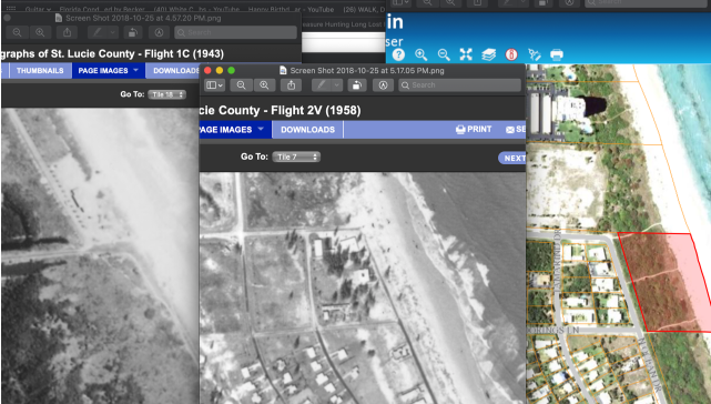
Old and New Photos of The North Fort Pierce Causeway Area.
Submitted by Dave J.
People often talk about how items sink and get moved on a beach.  Movement is a relative thing.

Beaches are dynamic.  Beach sand moves a lotHow the sand moves is often more important than how other items move.  That is often missed.

People often think that when an item or wreck suddenly shows up on a beach that it was washed up and when an item disappears, it sank.  Fact is that just as often the item moved little or not at all, but the sand moved.

Yesterday I was talking about how the sand moves and showed the Fort Pierce inlet area as one example.  Dave J. got what I was saying and did some research on his own.  He sent the above pictures of the area just north of the inlet for comparison.

Dave said, I was just looking at the FP inlet and used some old 1948, 1958 pictures of the corner at north causeway and A1A. Attached is old vs new and looks like an entirely new parcel of land was created (red outline). 

Thanks Dave! That is a great illustration.  

As I said yesterday, the area to the north of the inlet is an area of accretion, while the beach to the south of the inlet tends to erode.  That means that items to the north of the inlet will tend to get covered, while items to the south will get exposed when the sand erodes.

New discoveries are often made south of inlets where the natural flow of sand is interrupted, while older items to the north get covered.  That is on the west coast where the prevailing long shore currents are north to south.

If you want to buy beach front property, you might want to think about an area to the north where the beach will increase, instead of in an area where the beach will be disappearing.

Here is another look at the photo I posted yesterday.

Fort Pierce Inlet.
Compare that with the picture of the Jupiter Inlet (below).

Jupiter Inlet.
Notice the similarity.  Notice how much more narrow the beach is towards the top of the photo.  That is not all perspective.

Once again, the beach to the south of the inlet would be even farther back if it wasn't for all of the beach renourishment projects.

If the Jupiter wreck scattered to the north, it could now be under the accreted sand.

---


This photo of a couple on a high ledge at Yosemite is real.  It looks like fantasy art, but it is not.  Yosemite has the most dramatic scenery of anywhere that I have been, and I'd recommend it to everyone, at least once.

Here is a link to a story about that.   Unfortunately a couple taking a selfie fell off.

https://sanfrancisco.cbslocal.com/2018/10/25/couple-fatal-fall-yosemite-parks-taft-point/

Many years ago I hiked up a trail that got VERY narrow and looked straight down hundreds of feet.  It was too much for me, and I turned around and went back down.  Once I got to the trail head, I looked back and saw a sign at the entrance that said, Trail Closed - Falling Rocks.  Didn't matter to me, because it was way too high and the path on the ledge way to narrow even if it was stable as the Rock of Gibraltar.

---

The tides on the Treasure Coast are nice and high.  There is a beautiful full moon.

There won't be any big surf for a while.

Happy hunting,
TreasureGuide@comcast.net

Friday, October 26, 2018

10/26/18 Report - Where Is The Treasure Now? One Thing You Should Know. Red Tide in Vero.


Written by the TreasureGuide for the exclusive use of treasurebeachesreport.blogspot.com.

Fort Pierce Inlet.
Snipped from Floridadep.gov.  Full link below.

I mentioned a project to find gold bars dropped along a West Coast beach a few decades ago.   The bars were scattered to some extent.  Those hunting the bars have a general description of where the bars were dropped (scattered)  relative to the beach and a delta.

Since the bars were dropped a few decades ago, the first thing I'd want to know is where the shoreline was when the bars were dropped relative to where the shoreline is now.  Beaches change over time and it is important to know where the beach was relative to where it is now.  That is often an overlooked and very important piece of information.

Let's just say the bars were said to be dropped along the shoreline very close to the water.  Where was the water line at that time?  Was it farther out than it is now, or is it now under the beach.

If we use the Fort Pierce inlet area as an example, we know that north of the inlet the sand has been accumulating for quite some time, and the shoreline just south of the inlet continually erodes.  The shoreline to the north of the inlet has been moving one way, while the shoreline south of the inlet has been moving the other.  If the bars were dropped along the waterline, if they were dropped north of the inlet a few decades ago, they would probably be under the beach now.

Fortunately there is good detailed data on shoreline changes.  For Florida you can find very detailed data for most of the 20th and 21st century.  If you do the research you can find out where  the beach was back some years ago and compare that with where the beach is now.

If you were told that a bar was buried ten yards back from the water line fifty yards south of the Fort Pierce inlet fifty years ago, it might seem like you'd have a good idea of where that bar was.   However, the shoreline might have changed a lot in those fifty years.   In recent years the beach just south of the inlet changes a hundred yards east/west every year or two when they renourish the beach and then it erodes again.  You can't just go out to the waterline and march back fifty yards and figure that is where the bar is.

It doesn't have to be bars of gold.  Resort beaches have changed the same way.  One beach that I hunted a lot in the past is now covered by at least a hundred yards of new sand.  The beach and dips in front of that beach that I worked thirty years ago are now deeply buried, as are the items dropped there back then.  It helps a lot to know where the beach was compared to where it is now.

Below is an example of a map that shows how erosion changed a shoreline between 1954 to some time in the 2000s.  If there was a swimming beach at this location in the 1950s hundreds of yards farther out than they would be most recently.  Or if there was a shipwreck offshore, it would now be much farther out from shore.

Map Showing How a Shoreline Changed Over a Few Decades.

There will be daily, monthly, yearly changes, but there are also fluctuations that occur over decades and centuries.   A shipwreck that was in the water could now be under the beach if it is in an area where there is accretion rather than erosion.

Florida provides an immense amount of shoreline data.  The database is not easy to use unless you are familiar with it, but the information is there if you are willing to do the hard work.

Here is a link to the Florida shoreline database.

https://floridadep.gov/water/beaches/content/historic-shoreline-database

If you take the time to dig into it, you'll be amazed at the detail that is available.  There is map, survey and photographic documentation on virtually every foot of shoreline.

If you look at the photo at the top of the post, you'll see that there are six small red triangles west of the shoreline.  Those are the survey monuments.

The Florida Public Land Survey System (FLPLSS) was established by the United States Government Land Office (GLO, now re-organized under the Department of the Interior, Bureau of Land Management, BLM) beginning in 1824, with the establishment of the Initial Point in Tallahassee. This system of rectangular survey grids was gradually extended through the remainder of the 1800's eventually covering the entire state, dividing all the public lands first into six mile by six mile areas (Townships), then subdividing these Townships into one mile by one mile regions (Sections). Physical survey markers, or monuments, were placed every half mile on these section lines to delineate the surveyed lands. Monuments were also placed at points on the section lines where they intersected bodies of water or previously occupied (private) lands...

(Source: http://sfrc.ufl.edu/pdf/faculty/gibsonresearch.pdf)

I better wrap this up.  If you have a general description of the location of a beach treasure, the first thing you might want to do is check to see how the beach has changed since the time of the description.  It seems that people don't appreciate how much or how rapidly beaches change.  You will want to know where the beach is now compared to where it was in the past.

Shipwrecks that were once underwater can now be under sand.  Treasures that were once buried on the beach, can not be out in the water.  People talk a lot about how items move, but beaches move too.  The movement of the beach is just as or more important than the movement of the items.  A lot of data is available if you are willing to dig it out.

--

There is a lot more to be said on the above topic.  I might pick up on it again real soon.

One reason I chose the picture at the top of the post is that it is not a simple case.  It is more complex than an unbroken stretch of beach.  See if you can see how the sand is flowing at various spots.

---

I've noticed that more people are starting to use DuckDuckGo.
DuckDuckGo says, DuckDuckGo is an Internet privacy company that empowers you to seamlessly take control of your personal information online, without any tradeoffs. With our roots as the search engine that doesn’t track you, we’ve expanded what we do to protect you no matter where the Internet takes you.

See DuckDuckGo.com.

---

It seems that the Indian River beaches have some of the most toxic Red Tide contamination.


---

Happy hunting,
TreasureGuide@comcast.net

Thursday, June 28, 2018

6/28/18 Report - Context On Treasure Coast Cob Finds. Mexico Minted Half Reale. Arcadia Mills Archaeology Dig.


Written by the TreasureGuide for the exclusive use of treasurebeachesreport.blogspot.com.

Mexico Minted Half Reale.
Let me put some things in context today.  Recently I've been showing some cob finds.  There were days when several were found.  That doesn't mean that it was typical to walk out on the beach and find that many.  I was living in the Fort Lauderdale area when I started hunting the Treasure Coast.  That means that I had to drive up to hunt without knowing what beach conditions were like on the Treasure Coast.  There was no Treasure Beaches Report.  In fact people didn't have the internet - or cell phones.  There are some advantages you have today with the new technologies, detectors and information sources.

There was no good way to know what beach conditions were like without going to the beach and taking a look.  For me that meant driving a couple of hours.  I would drive two hours often to find nothing but a crummy looking beach.  I made a lot of those trips before I ever found a single cob.  I was getting discouraged and didn't think that I would ever find one.

People tend to think that because there were days when several coins were found that it was always good in those days or that it was much easier.  You often hear people say that it has all been found or there isn't much left and it is much harder today.  I completely disagree with all of that.  It is very much the same now as it was thirty or forty years ago.  It wasn't easy back then, and it isn't easy today.  That is why I have so much to write about.

The one big thing that I think has changed is the frequency of beach renrouishment projects and the amount of sand being dumped on our beaches.  I do believe that has had an effect.  The dunes are protected and don't erode when they otherwise would if it weren't for the renourishment sand.  And the renourishment sand in the water protects the beaches to some extent.

Still, there are good days and bad days.  Some years are better than others.  And some decades are better than others.  Nature has the biggest effect.  There are times when you get a lot of rough weather and erosion.  There are also times when you get a lot of accretion.  Just like the normal winter and summer shifts.

Winter typically makes for better beach hunting than summer - other than tropical storms and hurricanes.  Sand tends to accumulate on the beaches in the summer and the rougher winter weather tends to strip it off.  I've long said that the best treasure beach hunting, with the exception of after good summer storms, is September to April.  And November to February is the peak for treasure beach hunting.  My records of finds confirms that.

There are both long term and short term trends.  There are days, months, and years when things either improve or deteriorate.  If you get a long-term trend of erosion in one area and then get a few good days on top of that long term trend, you have a real good shot.  The same few good days on top of a long-term trend of accretion or towards the end of a summer of southeast winds and accretion, won't likely produce much of anything.  A few additional feet of erosion on a beach that has already been losing sand will produce more finds than the same erosion after a few weeks, months or years of accretion. (For this discussion I'm not taking into account shallow water conditions.)

When you pile sand up in one place on the beach where nature was taking it away, it will erode faster than ever.  It creates a vicious circle.  Not all erosion is the same

I've never detected after the hurricanes that produced some of the best detecting and biggest finds.  I've missed those times when the hunting was at its absolute best.  For example in 2004, I had a lot of other responsibilities that were more important.

In the past few years beach hunting has been slow.  It is a combination of things.  There has been a lot of beach renourishment and the weather hasn't been helping either.  That is one trend, but it won't last forever.  You have to take a long term perspective.  Some times its hot and other times its not.

.---

Philip Monogram on Same Half Reale Shown Above.

This is the same half reales shown at the top of the post.  It is one of those that was not completely labeled so I don't know when it was found.

This one is on the thin side and has a lot of surface area.  It is pretty much as found and could use a little cleaning.  You can see some shells and crust.

---

 ... “And, in excavating it, we found a big iron concretion, about fist size, with turtle shell fragments sitting on top of it,” said Walker, noting that they had the iron X-rayed in the UWF lab. “It looks like it’s a perfectly circular item, about 2 and a quarter inches wide in diameter.”
Walker believes the metal object could be associated with ritual or religious activity by the slaves. They expect to have a better idea in a few weeks, after conservation and cleaning in the electrolysis tank...
Here is the link for the entire article about the dig at the Arcadia Mill site.


http://wuwf.org/post/uwf-researchers-build-story-arcadia-mill-homestead-find-slave-cabin-chimney

---

Happy hunting,
TreasureGuide@comcast.net

Tuesday, May 1, 2018

5/1/18 Report - More On How Sand and Objects Move In The Water and On The Beach.


Written by the TreasureGuide for the exclusive use of treasurebeachesreport.blogspot.com.

Tires In Indian River Lagoon.
( I pulled the vegetation-covered one out of the water. )

Hours, days, weeks, months, decades, centuries are all units of time that can be appropriate for describing beach sand cycles.   By "beach sand cycles" I mean the cycles of beach accretion and erosion on specific beaches.  Besides sand, other objects wash in and out in cycles of varying length.

A beach might erode for an hour, day or week before filling in again, but there are what I would call long-term and short-term cycles.  To give an example, Bathtub beach and Fort Pierce South Jetty beach will continue to erode for years, decades and even centuries.  There are stationary obstacles that cause the erosion, such as the rocks and houses in one case, and the jetty in the other case.  Despite the long term trend of erosion, there will also be shorter term cycles when the sand actually builds a little in those locations and then erodes back again.  So even though a beach might generally erode for a week or so, there can also be daily or hourly fluctuations.

But not only does the sand come and go in cycles, there are also periods of time when other objects, such as coins, come or go, and those periods are not perfectly correlated with the sand cycles.  I've explained why that is in the past.  I have been observing this lately in the Indian River Lagoon.

There is, believe it or not, a bit of a beach along the west side of the lagoon, and like other beaches, it comes and goes.  The waves do not get as high as they do on the ocean, but at times they reach a foot or more.  They usually hit the west bank of the lagoon.

I consider the beach along the west bank to provide a small scale model of an ocean beach, admitting that there are some differences - one being the average size of the waves and another being the tidal change of current.  As you probably know, the water flows into and out of the lagoon with the tides.

Since I drive up Indian River Drive frequently, I keep watch the lagoon to see what is happening there.  You might remember that I once said that the west bank of the lagoon was littered with a mass of bottles after the 2004 hurricanes.  There was a solid thick line of bottles along the west bank - some fairly old.  After the hurricanes, the erosion caused so much damage to the banks and Indian River Drive that they put sheets of connected concrete blocks along the west bank between Fort Pierce and Jensen to hold the banks in place.  That project must have taken about two years, as I recall.  After a few years ( I don't remember exactly how many ) the bottles disappeared.  The source of many of the bottles was also cut off.  Many came from the banks where people used to discard their garbage before the days of garbage collection, but the banks and anything on the banks was now covered by concrete sheets.  So there were few bottles left in the water and on the small beach, and it appeared that no more would be washed onto the beach or into the lagoon from the banks.

After a very long period of very few bottles other than new trash thrown from cars, boats or whatever, the bottles began to reappear again couple of years ago.  Not only bottles, but old tires too.  The old tires are have been washing in, especially the last few weeks.

I've been watching the tires appear and move in towards the beach.  Also I've been tracking a few other objects, but the tires are plentiful and easy to track.  Tires are increasing in areas where there  were some before but are showing up where I have scarcely ever seen them in the past fourteen years.

I'm not really much interested in how tires or bottles move in the lagoon, except for what it can teach me about the movement of objects in general in the water and on a beach.  I believe there are some important lessons to be learned there.

I always say that one of the big factors that determines how objects move in the water and on a beach, besides the density, is the shape of the object.  Bottles and tires obviously have very different shapes and both are very different from coins.  Both are very interesting, but the big hole in the middle of a tire collects sand as does the space that would be filled with air when the tire is inflated.  It becomes very heavy and all that sand inside puts a drag on it.  You'll be surprised how hard it is to move a tire filled with sand in shallow water.  They become very heavy. yet in recent days and weeks the tires in the lagoon have been moving at a rate of at least a few feet per day.  Remember, the surf in the river seldom gets over a foot, yet these flocks of tires are migrating to the beach, and they haven't done that to this extent since before 2004.

Area Where Tires Have Been Accumulating For Years.
The photo at the top of the post shows where tires are now washing up for the first time, and the photo immediately above shows an area not far away where they have been accumulating for a longer period of time.  I think you can see how difficult it would be to move a tire that is half buried and filled with wet sand, yet they are moving daily in the small surf of the lagoon.

While coins are obviously different from tires, there are periods when coins move, just like there are periods when tires and bottles move.  So what is the thing that prevented the tires from appearing for so long before they recently showed up and started moving in towards the beach.  I can't answer that precisely right now, but the obvious answer is that they were previously buried.  Just like coins they won't move as long as they are buried - not unless all the sand they are under is moved too.

In the past I've mentioned the tons of sand in front of the ocean beaches and how it will protect the coins and keep them from being washed up onto the beach.  That sand has also protected most of the ocean beaches from eroding much over the past couple of years.

When talking about the junk washing in, one person who spends a lot of time wind-surfing in the lagoon, said there is no sea weed in the lagoon right now - at least not where he goes.  His thought was that the stuff that was normally under the vegetation was now free and getting washed in.

I noticed that many of the bottles that have been showing up lately were covered with barnacles and vegetation.  So are the tires.  Unfortunately I haven't been fishing or out in the water in the lagoon enough lately to say if the sea weed is just buried or if it has died or what, but sand has been moving in for the past couple of months and building bars.  That is happening while the bottles and tires are moving in.

The lesson today is not about tires or bottles.  The point I am trying to emphasize is the various periods when different things, including sand, bottles and coins move.  They move at different times, and as I've said in previous posts, according to the force of water and other factors, including the density and shape of the objects in question.

---

What do you call a flock of tires?  Anything you want I guess.  I'd say a "bunch" or a "mess."

The surf along the Treasure Coast is up to three to five feet today and expected to stay the same tomorrow.  The tides are decent.

Happy hunting,
TreasureGuide@comcast.net

Monday, February 27, 2017

2/27/17 Report - Yesterday's North Wind Caused Erosion To Some Treasure Coast Beaches But Not Others. Examples From a Couple Beaches.


Written by the TreasureGuide for the exclusive use of treasurebeachesreport.blogspot.com


Yesterday I mentioned the north wind that blew most of the day and I said I was sure there would be a spot or two with some cuts.  This afternoon I got out to take a look.  Above is what I saw at John Brooks.

I"m sure the cuts were better yesterday.  You can see seaweed in this picture.  I'd say the beach filled in a little, which you would expect because the wind today was now out of the south.  The seaweed is a good indicator of accumulating sand.

Below is another picture of the same beach.


There were a couple detectorists there this afternoon.

Frederick Douglas beach was not as nicely cut, but had evidently filled in some since yesterday too.

This year we've had other brief windows of opportunity when a front came through, but they are only lasting about a day.  We haven't gotten any sustained cutting.

Another thing about the above cuts is that they were in sand that had recently accumulated.


Here is another beach as seen Monday afternoon.  This one had no cuts.  

This beach had at least a foot of new sand built up on the front beach in recent days.  You could see that sand clearly below the seaweed line.

There was probably more than one cut beach yesterday, but I haven't yet heard any reports from other areas.

---

I found s dissertation on beach-stranded shipwrecks, and the following illustration was in it.

The summer beach profile is shown in yellow.  The winter beach profile is shown as a red dotted line.

In reality a beach wobbles back and forth continually.  One day you'll have erosion and the next accretion.  

There are the larger seasonal trends and then the shorter duration trends.


Yesterday we had erosion, and then when the wind shifted returned to accretion.  This isn't anything really new or anything that I haven't said before.

Another thing that sticks out is the fact that our surf wasn't real big yesterday, yet we got some decent erosion.  One thing I harp on is the direction of the wind and waves, which is also very important.

It was the direction of the wind yesterday that I was going by when I said there would probably be some erosion. 

That is as far as I'm going today.

Happy hunting,
TreasureGuide@comcast.nets

Sunday, November 15, 2015

11/15/15 Report - Current Treasure Coast Beach Detecting Conditions and Predictions.


Written by the TreasureGuide for the exclusive use of treasurebeachesreport.blogspot.com.


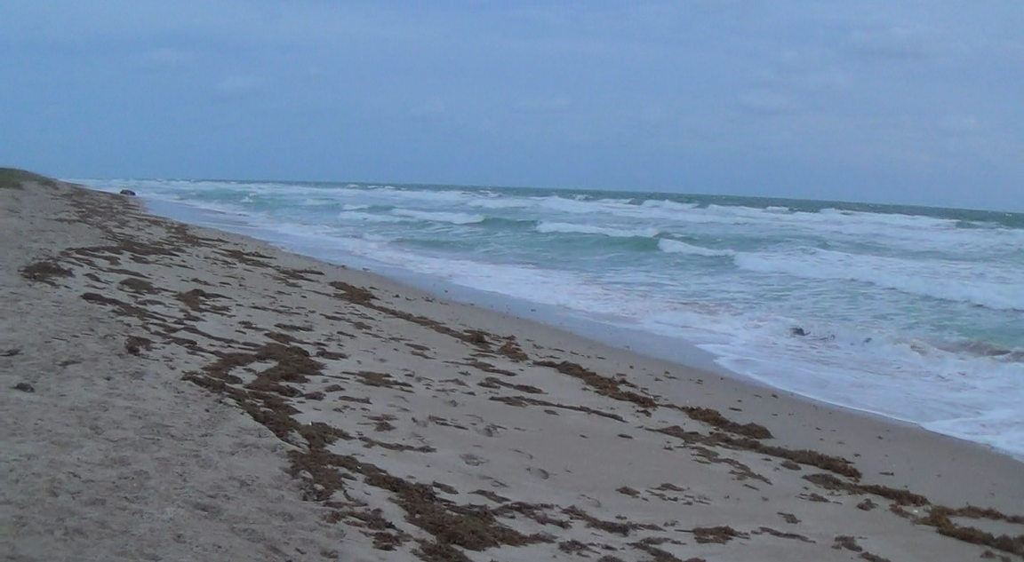
Treasure Coast Beach This Morning.
As you know, we've been having a lot of wind and some waves.  I went out to the beach this morning to check it out.  I didn't expect much, and that is what I saw - not much.

Usually it takes up to six or eight foot seas to really improve conditions, but there are other factors involved.  The direction of the waves is very important, and the tides have an effect.

This time we had a brief period of north wind yesterday and then it turned.  The waves this morning were hitting directly from the east.

The first beach I visited this morning is shown above.  Nothing but some shallow scallops.  The water had been up fairly high, but no erosion on this beach.

Another Treasure Coast Beach This Morning.
There was no erosion at the next beach I visited except for one small stretch.  The cut there was less than a foot high and not very long.

Note the sea weed.  That is an indication of accretion, not erosion.

Small Cut.
This small cut evidently occurred during a previous high tide before the wind changed.  The sea weed in front of the cut shows that after the cut was created and the wind changed, it started to fill again.

Small Boat Washed Up Onto Beach
At least we've been getting some rough water lately. October and November have traditionally been pretty good months for detecting.  We often get some of our first storms then.

We need to get back down to the sand levels we had back a few weeks ago and then some.

The next few days we're supposed to have 3 - 5 foot surf.  On Wednesday it is supposed to be a bit higher, maybe up to seven feet.

If the wind direction stays as predicted, it won't be good.  Nothing but east and then southeast winds.  I'm not expecting much improvement in beach conditions from that.

I'm sticking with a 1 rating on my Treasure Coast Treasure Beach Detecting Conditions Rating Scale. I'll hope for something better but am not expecting it.

If you scout around some you probably be able to find some small cuts and slightly better spots.

I have some pictures of my favorite finds from my trip up north ready to show.  I'll probably do that tomorrow.

Happy hunting,
TreasureGuide@comcast.net


Saturday, March 8, 2014

3/8/14 Report - Sand Movement and Obtacles, Speed Limit in 1861, Class Ring, Expensive US Coins.


Written by the TreasureGuide for the exclusive use of treasurebeachesreport.blogspot.com.

Sand bar created by obstruction near shore.

I'm still having trouble uploading videos to blog posts.  I had one for today but ended up making a series of stills out of it to illustrate my point.

In this first picture the shore line runs left (north) to right (south), pretty much along the bottom of the photo,and the log sticks out from the shoreline in something like a 45 degree angle.  Most groins, which I talked about back a few posts, would stick out at about 90 degrees, of course,  Nonetheless the principles are basically the same.

In this illustration the waves have been hitting from the upper left corner in about the direction of the arrow.

The water was coming up onto the newly created sand bar that you see to the left of the log.

Notice the lack of sand to the right of the log.  That is what you would see happen as the result of long shore drift, which on the Treasure Coast is north to south.  Look at our inlets and jetties and you will see something very similar.

Picture two showing direction of water.

Picture two (above) shows the direction of the water as it comes onto and up over the sand bar.

In the upper left corner you see a wave about to hit the sand bar.

The sand bar builds as the water washes sand in from the upper left,  The waves crash in front of the sand bar, suspending sand and moving it up the slope.  As the water slows down as it goes over the bar, the water loses speed and drops the sand.

Some of the water that makes it over the bar runs to the right and back down along beside the log.  However, as both this water and the water running back down the front of the slope goes out, there is another wave coming in which crashes into the receding water, thus stopping it from receding unabated.  That creates a brief zone of no current where some items are dropped for the moment.

If the size of the waves do not increase as the tide goes out, everything will happen closer to the top of the picture farther out in the water and the bar will be extended out into the water.

Picture three showing how there is little sand on the right side of the log.
Of course the waves are coming in from the same direction on both sides of the log  (from the top left of the picture).  However you can see that on the right side of the log, there is no sand build up.

The sand to the right of the log keeps moving to the right along the shore with the direction of the waves that are hitting at an angle.   There is no sand moving in to replace the sand that is moving out on that side of the log.

When you find a situation like this, no matter if the obstacle is a groin or a log or rocks or whatever, the place to hunt is on the side where the sand has been depleted.  That is where items that might have been dropped over time and accumulated could be uncovered.

If the wind changes and the waves change direction (then coming from the upper right hand corner)
the process would be reversed, though not completely because of the angle of the log, and the sand would build on the right side of the log and be removed from the left side.  Then you would want to hunt the left side.

Due to our north to south running near shore currents on the Treasure Coast (the opposite of the Jet Stream by the way) the predominant direction is for beach sand to travel north to south.  So when you have a significant sustained reversal you might get a good opportunity to hunt the north side of obstructions.  Watch for those unusual opportunities.

When the wind and waves are hitting from the south, it has to be large and sustained to have a significant impact for a variety of reasons.  One the wave energy coming from the south is moving against the near shore currents and the sand pushed in the direction in the past has to be moved before you get down to productive levels.

Swimmers often like to hang out on sand bars, so when a sand bar moves, that is a good place to be.

Recent Find Found by Using
Knowledge of Moving
Sand Bars
If you know about how forces like these work and you know your different beaches, you can intelligently decide what places you want to check before you leave home.

Sand bars are obstacles to the flow of sand too, as are holes, rocks, etc. etc.

Get to know your beaches and how they respond to different conditions.


Today I started a new experiment to show how objects of different size and weight sink in sand.  It is not a very refined experiment but in the first ten minutes I was seeing interesting results.  I'll report on that some time when the experiment is done.


Did you know that you could receive a fine for speeding in St. Augustine in 1861?

City of St Augustine vs Lewis slave of B Olivero; Fast riding through the Streets - January
26, 1861 (St. Augustine City Court Record)
On this day appeared Bartolo Oliveros owner of said slave Lewis in answer to complaint made by City
Marshal against said slave for riding through the Streets of said City on the 20 inst at a faster gait
than permitted by the City Ordinance.

The said Bartolo Oliveros owner of said slave having admitted the guilt of his said slave. His honor
ordered a fine of five dollars to be entered against said Bartolo Oliveros owner of said slave and that
said slave stand committed until said fine and cost be paid.


Here is the source link.   It has numerous interesting tid bits on Florida history.

http://www.drbronsontours.com/bronsonhistorypageamericanstaugustinecivilwar.html


The President's new budget gives the US Mint  the authority to do research on the composition of coins and authority to change the composition of coins.

The latest figures available from the United States Mint indicate a cost of 1.83 cents to produce and distribute each cent and a cost of 9.41 cents for each nickel. All other denominations cost less than their respective face values to produce and distribute.

The cost of making and distributing 5 pennies is about the same as one nickel.

Here is the link.

http://www.coinflation.com/coinage_material.html


We are having north winds and around a four or five foot surf this weekend.  It isn't enough to appreciably change detecting conditions on the Treasure Coast.  That is why I've been targeting modern finds lately.


Happy hunting,
TreasureGuide@comcast.net