Showing posts with label maps. Show all posts

Monday, November 4, 2019

11/4/19 Report - Some Moving Sand. Gold Nuggets and Silver Bars. Ais Indians Along Treasure Coast.


Written by the TreasureGuide for the exclusive use of treasurebeachesreport.blogspot.com.

Frederick Douglass Beach Sunday Evening.
I took a look at the beaches Sunday evening and found some cuts at John Brooks and Frederick Douglass beaches.  Those cuts weren't there Friday.  The cuts were not as strong as those I found on Oct. 26.

It was a little after high tide on Sunday evening when I took these photos.


Frederick Douglass Beach Sunday Evening.

In front of the cuts the beach was typically still mushy.


John Brooks Beach Sunday Eventing.

At least some sand was being removed at these beaches, although I don't expect it to continue much.


John Brooks Beach Sunday Evening.
---


Yesterday I showed a couple especially nice lots that recently sold in the current Sedwick auction.  They were cobs from the 1715 Fleet.  Today I'll mention a couple more lots that I found particularly interesting.

Gold Nuggests From Rio Mar that Recently Sold at Auction.
Source: Secwick Coins Treasure Auction No. 26 Online Catalog.


One is the small group of gold nuggets shown above that were found at Rio Mar.  That lot sold for $1300 plus buyers premium.   Below is the lot description.

Lot of seven small gold nuggets, 1.12 grams total, ex-1715 Fleet. Each up to 1/4". Very few natural gold nuggets were found on the 1715 Fleet, so it seems odd that the Fisher marketers did not separate this lot into seven individual artifacts, but fortunately these pieces have retained their original plastic artifact tag and certificate. A few of the nuggets (mostly flat) are tiny, but some are substantial, and most likely they were being carried as "tax free" wealth by a passenger. From the 1715 Fleet ("Rio Mar" site), with original Cobb Coin Co. (Mel Fisher) plastic tag and photo-certificate #CC86-025.

It wasn't too many years ago that I found three nuggets at John Brooks beach.  

At one point salvagers attempted to dredge fine gold flakes at Rio Mar, but weren't very successful and gave up on it.

---

Lot 208 was sold for $48,500 plus the buyers premium.  Lot 208 is the Atocha silver bar of over 92 pounds shown below.


Here is the lot description.

Large silver Atocha bar #779 from Potosi, 92 lb 3.84 oz troy, Class Factor 1.0, with markings of mine / date Po1621, manifest IIIIULI (4051), and fineness IIUCCCLXXX (2380/2400) followed by cartouche of assayer Mexia, shipper / owner's marks (Arriola) and tax stamps, from the Atocha (1622), with original stock certificates. 13-1/2" x 5" x 3-1/2". A rather large example with choice full markings, especially the manifest number and the silvermaster's "V" in one corner, plus full date 1621 and nearly full tax stamp in addition to the fineness and assayer, with typical double-scoop assayer's "bite" in center, but perhaps best of all is the elegant diamond-topped AR monogram with what looks like a magic wand (all of which apparently refers to shipper / owner Arriola) near the left side, quite a showpiece for the advanced Atocha-bar collector. From the Atocha (1622), with original Fisher photo-certificate #85A-S779 and investor folder containing three Treasure Salvors, Inc. stock certificates from 1986 (525, 1500 and 1517 shares).

Heavy silver bars from wrecks like the Atocha typically bring high prices at auction.

---

Here is some good reading: The Location of the Paramount Town of the Ais Indians, as presented in the The Florida Anthropoligist, Sept. - Dec. 2010 issue.

If you like Florida history, I think you will enjoy this well-researched article of over thirty pages packed with maps and references.


Thanks to DJ for that link.

---

It is still breezy today, but the tides are smaller and the surf is getting smaller too.  I don't know what might have happened to the beaches overnight, but yesterday there was some positive movement.


It looks like next week we have a chance for some higher surf again.

Happy hunting,
TreasureGuide@comcast.net

Tuesday, January 22, 2019

1/22/19 Report - Google Maps and Changing Landscapes. Lunar Eclipse. Columbus Verboten. Bigger Surf.


Written by the TreasureGuide for the exclusive use of treasurebeachesreport.blogspot.com.

Eclipse As Seen From Treasure Coast
and Captured by Alberto S.
I missed the eclipse, but Alberto sent me the beautiful images that he captured.  He said the last image was from about 12:10 AM.  He said it felt like it was freezing outside.

Great images Alberto!  Thanks!

---

I've talked a lot about using old maps and the benefits of knowing the history of a place.  I'm amazed how seldom people reference old maps to check out shoreline and other topological changes.  Targets that were once on land might now be either in the water or more deeply buried under sand that has accumulated.

Recently I was talking about the advantage of having personal knowledge of changing landscapes.  Now it is possible to get GPS positions and compare those to images to see how things have changed.

Here is one example of what I was talking about yesterday.  The satellite map is from Google Maps.  It shows some of the changes I mentioned yesterday and illustrates how having a knowledge of the past can help you locate old treasures.

A View of An Area That I Was Very Familiar With Back a Few Decades Ago.

This area has changed a lot since the 1950s.  Where you see the bull-dozed dirt, there was an old barn (big rectangle) and a corn crib (little rectangle beside it).  

The house across the road with two cars out front was a small wash house, where several young local families got their start with housekeeping before getting their own house.  The rectangle behind that, was an outhouse, that later was filled with great old cork-top bottles, many with paper labels.

Across the road from that was a small dump in a little ravine by the current telephone poll.

The two blue arrows point to the winding creek where we threw bottles and shot them with BB guns.  Funny how toxic masculinity was fostered back when there was so much less crime.

Across the creek were no buildings or roads up until more recent decades.

The good old dump is the area indicated by a circled X.  It is right across the road from a three story farm house.

There is much more that I could show on this and neighboring maps, but that is enough of an illustration for now.  There were locations where arrow heads were routinely found and many other things.

I think you can see how knowing the history of the place would be a huge advantage for a detectorist.  There are many good detecting sites that would not be apparent to those who don't know the history of the place.

Although I haven't been able to spend much time, I have had a few short hunts there and quickly dug up some of the old metal toys that I played with as a child as well as some silver coins around the old ball field that is now hidden by weeds and trees, so I know those things are still there if only I was there and had the time to work them.

The same thing applies to the beaches.  I was not raised on the Treasure Coast, but I have been here long enough to observe some of the changes.

Here, for example, is the Blind Creek area.  The access road to the south of the lake has been closed for some time.  There was a parking lot where I drew the blue rectangle.  It washed over in the 2001 storms and kept filling in.  I think they eventually gave up on keeping it open.   Anyhow it has been closed now for quite a while.

Blind Creek Area As Seen With Google Maps.

Where you see the blue semi-circle, the beach was eroded back close to the lake.  Just a little more erosion and it could have opened to the ocean.  I don't doubt that it was at some time an inlet, although I don't know that for sure.

There is a lot more to know about just that little area, for example the Native American habitations, or where the WW II observation tower was, or the WW II dump to the south.  You can still find evidence of all of those today

Landscapes change and beaches change.  Some changes are rapid and permanent.  Knowing about those changes can help the detectorist in many ways.

---

SOUTH BEND, Indiana - The University of Notre Dame will cover murals in a campus building that depict Christopher Columbus in America, the school’s president said, following criticism that the images depict Native Americans in stereotypical submissive poses before white European explorers...

Here is that link.

https://cruxnow.com/church-in-the-usa/2019/01/22/notre-dame-to-cover-up-murals-of-columbus-in-the-new-world/

I have so much to say about that but I won't.  It is just too much.

---

Google Maps and similar web sites provide a convenient method for checking out sites that you haven't been to for a while or comparing to older maps.

The wind is out of the east at about 15 to 20 mph this morning.

I hope to get a chance to look at the beach some time today.


Source: MagicSeaWeed.com.

The tides are still nice and big.

Looks like the Treasure Coast surf will be a bit bigger tomorrow, but the wind will shift to the south.

Happy hunting,
TreasureGuide@comcast.net

Wednesday, November 21, 2018

11/21/18 Report - The Importance of Tracking Beach Movement Over Time. Big Surf Predicted.


Written by the TreasureGuide for the exclusive use of treasurebeachesreport.blogspot.com.

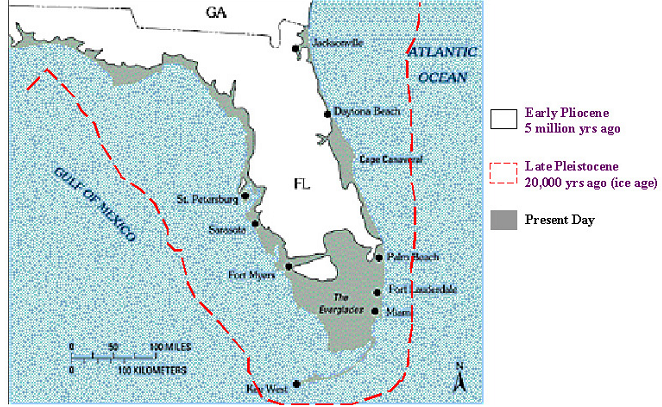
Florida's Changing Coastline.

Beaches move.  Beach sand moves constantly.  It is a complex choreography with countless moving grains - some moving in one direction and others moving in another direction - some moving rapidly and some moving slowly.

Sand is moved by wind and water.  I'm sure that doesn't surprise you, but the consequences are important for the beach hunter.

People talk about how items sink on a beach.  As I've argued before, items on a beach rarely move if the sand doesn't move.  Prove it for yourself.  Get a bucket of sand, put a coin on the top of the sand, and you'll be able to observe that a coin won't sink in resting sand.  Coins don't work their way down into sand like sand-fleas, moles or worms.  The biggest factor is the movement of the sand.

If I wanted to find old things at the beach, one thing I'd really like to know is the history of the beach and how it has moved over time.  The beach won't be where it used to be.  The sand will come and go many times in a year.  Beach could be a long distance from where it used to be. And even when the surface looks the same, the sand could have eroded several times and then filled again.  As that happens, objects will generally tend to settle lower.

I can remember times when local different Treasure Coast beaches were very different from what they are like today.  I'm sure you can too.  I remember, for example, when an old concrete foundation was exposed at the water's edge between John Brooks beach and the condos to the north.  I only saw it once, but I'm sure it is still there.  Of course the waterline is not where it was then.  In the same area, there was also once a line of tree stumps in the shallow water.  I haven't seen them again either.  The water line at that time was much closer to the condos than it is today.

I'd love nothing more than to have a overhead stop-motion video history of the beach changes.  You'd see the beach move in and out, slowly sometimes and at other times very quickly.

People often use stationary landmarks to judge beach changes and determine when old items might appear.  It wasn't long ago that I posted how people used a car frame up by Vero to judge when hunting would be good.  That car frame is gone now, but it provided a marker to estimate the movement of sand.

The illustration at the top of the post shows how much the Florida coastline has changed.  It changes year to year to, and even day to day.  Those changes are important to the beach hunter.  Many old objects that were once in the water are now covered by the beach, and other objects that were once on the beach are now in the water.

The beach can change quickly when there is a big storm.  Here are some photos of changes caused by hurricane Michael that did so much damage not too long ago.


The photos show how one section of beach disappeared in a very short time.  Here is the link for more about that.

https://www.usgs.gov/news/and-after-coastal-change-caused-hurricane-michael

Here is another example from the same article.


These changes caused by Michael are easy to see.  Most of the time the movement of sand occurs more slowly, but it does occur nearly continually. I'm sure that some of the erosion that occurred during Michael has been reversed by now.

I'm often amazed that people, sometimes conducting very big operations, are so far off simply because they failed to take into account beach movement. Remember, the beach is now different than it was a year ago, ten years ago, and certainly hundreds of years ago.

One of my old favorite shallow water hunting spots is now under the beach and the new waterline is out at least a hundred yards from where I hunted in the water about thirty years ago.  A beach renourishment project caused that.  If I went back there today and walked out into the shallow water, I'd be far from the area where I used to hunt and the old stuff would be deeply buried under the beach.

If you have a beach target that is dated to a general time period, one of the first things I'd recommend is that you do some research and try to find maps from that time and figure out where the beach was then relative to where it is now.

---

A six to nine foot surf is predicted for Friday.  That is a bit of an increase since yesterday.  It could get interesting.

Source: MagicSeaWeed.com.

Happy Thanksgiving,
TreasureGuide@comcast.net


Friday, October 26, 2018

10/26/18 Report - Where Is The Treasure Now? One Thing You Should Know. Red Tide in Vero.


Written by the TreasureGuide for the exclusive use of treasurebeachesreport.blogspot.com.

Fort Pierce Inlet.
Snipped from Floridadep.gov.  Full link below.

I mentioned a project to find gold bars dropped along a West Coast beach a few decades ago.   The bars were scattered to some extent.  Those hunting the bars have a general description of where the bars were dropped (scattered)  relative to the beach and a delta.

Since the bars were dropped a few decades ago, the first thing I'd want to know is where the shoreline was when the bars were dropped relative to where the shoreline is now.  Beaches change over time and it is important to know where the beach was relative to where it is now.  That is often an overlooked and very important piece of information.

Let's just say the bars were said to be dropped along the shoreline very close to the water.  Where was the water line at that time?  Was it farther out than it is now, or is it now under the beach.

If we use the Fort Pierce inlet area as an example, we know that north of the inlet the sand has been accumulating for quite some time, and the shoreline just south of the inlet continually erodes.  The shoreline to the north of the inlet has been moving one way, while the shoreline south of the inlet has been moving the other.  If the bars were dropped along the waterline, if they were dropped north of the inlet a few decades ago, they would probably be under the beach now.

Fortunately there is good detailed data on shoreline changes.  For Florida you can find very detailed data for most of the 20th and 21st century.  If you do the research you can find out where  the beach was back some years ago and compare that with where the beach is now.

If you were told that a bar was buried ten yards back from the water line fifty yards south of the Fort Pierce inlet fifty years ago, it might seem like you'd have a good idea of where that bar was.   However, the shoreline might have changed a lot in those fifty years.   In recent years the beach just south of the inlet changes a hundred yards east/west every year or two when they renourish the beach and then it erodes again.  You can't just go out to the waterline and march back fifty yards and figure that is where the bar is.

It doesn't have to be bars of gold.  Resort beaches have changed the same way.  One beach that I hunted a lot in the past is now covered by at least a hundred yards of new sand.  The beach and dips in front of that beach that I worked thirty years ago are now deeply buried, as are the items dropped there back then.  It helps a lot to know where the beach was compared to where it is now.

Below is an example of a map that shows how erosion changed a shoreline between 1954 to some time in the 2000s.  If there was a swimming beach at this location in the 1950s hundreds of yards farther out than they would be most recently.  Or if there was a shipwreck offshore, it would now be much farther out from shore.

Map Showing How a Shoreline Changed Over a Few Decades.

There will be daily, monthly, yearly changes, but there are also fluctuations that occur over decades and centuries.   A shipwreck that was in the water could now be under the beach if it is in an area where there is accretion rather than erosion.

Florida provides an immense amount of shoreline data.  The database is not easy to use unless you are familiar with it, but the information is there if you are willing to do the hard work.

Here is a link to the Florida shoreline database.

https://floridadep.gov/water/beaches/content/historic-shoreline-database

If you take the time to dig into it, you'll be amazed at the detail that is available.  There is map, survey and photographic documentation on virtually every foot of shoreline.

If you look at the photo at the top of the post, you'll see that there are six small red triangles west of the shoreline.  Those are the survey monuments.

The Florida Public Land Survey System (FLPLSS) was established by the United States Government Land Office (GLO, now re-organized under the Department of the Interior, Bureau of Land Management, BLM) beginning in 1824, with the establishment of the Initial Point in Tallahassee. This system of rectangular survey grids was gradually extended through the remainder of the 1800's eventually covering the entire state, dividing all the public lands first into six mile by six mile areas (Townships), then subdividing these Townships into one mile by one mile regions (Sections). Physical survey markers, or monuments, were placed every half mile on these section lines to delineate the surveyed lands. Monuments were also placed at points on the section lines where they intersected bodies of water or previously occupied (private) lands...

(Source: http://sfrc.ufl.edu/pdf/faculty/gibsonresearch.pdf)

I better wrap this up.  If you have a general description of the location of a beach treasure, the first thing you might want to do is check to see how the beach has changed since the time of the description.  It seems that people don't appreciate how much or how rapidly beaches change.  You will want to know where the beach is now compared to where it was in the past.

Shipwrecks that were once underwater can now be under sand.  Treasures that were once buried on the beach, can not be out in the water.  People talk a lot about how items move, but beaches move too.  The movement of the beach is just as or more important than the movement of the items.  A lot of data is available if you are willing to dig it out.

--

There is a lot more to be said on the above topic.  I might pick up on it again real soon.

One reason I chose the picture at the top of the post is that it is not a simple case.  It is more complex than an unbroken stretch of beach.  See if you can see how the sand is flowing at various spots.

---

I've noticed that more people are starting to use DuckDuckGo.
DuckDuckGo says, DuckDuckGo is an Internet privacy company that empowers you to seamlessly take control of your personal information online, without any tradeoffs. With our roots as the search engine that doesn’t track you, we’ve expanded what we do to protect you no matter where the Internet takes you.

See DuckDuckGo.com.

---

It seems that the Indian River beaches have some of the most toxic Red Tide contamination.


---

Happy hunting,
TreasureGuide@comcast.net

Wednesday, August 30, 2017

8/30/17 Report - U. S. Geological Survey Web Site That Shows Areas Expected To Undergo Coastal Change Events. Harvey and Tropical Storm Ten Coastal Change Area Maps.


Written by the TreasureGuide for the exclusive use of treasurebeachesreport.blogspot.com.

U. S. Geogloical Survey Coastal Change Hazards Portal
Source: See link below.
Here is a great tool for identifying coastal areas likely to significantly erode.  It is the U. S. Geological Survey Coastal Change Hazards Portal.  The above picture shows the areas identified for coastal change due to Topical Storm Ten.  The bright red shows a high (97% probability of storm-induced collision and specific areas of South Carolina.  A good portion of the South Carolina beaches is marked.  If you go to the site, you can zoom in for a more detailed map and more specific information.

Here is the link


Texas is obviously going to have a lot of erosion - both coastal and otherwise.  I hate to think of the disaster as a metal detecting opportunity because the human loss and suffering is the highest priority, but this is a metal detecting/treasure hunting blog.  I'd encourage everyone to think of the human needs in Texas first and perhaps contribute to the relief effort in some way if you can.  I always end up passing up some of the best metal detecting opportunities during hurricanes because I think there are more important things to do.  There are people that need help.  We can, however learn a few things from the unfortunate event.  Earth and sand will be moved and historic items will be exposed that should be recovered before they are lost.  Despite what some would have you believe, they won't last forever and in many cases the archaeological context has been destroyed.

Using the U. S. Geological Survey Coast Change Hazards Portal, here is a look at the Texas coast.

U. S. Geological Survey Coastal Change Portal Showing Texas Coast.

As you can see, much of the Texas coast is in danger of inundation or overwash.

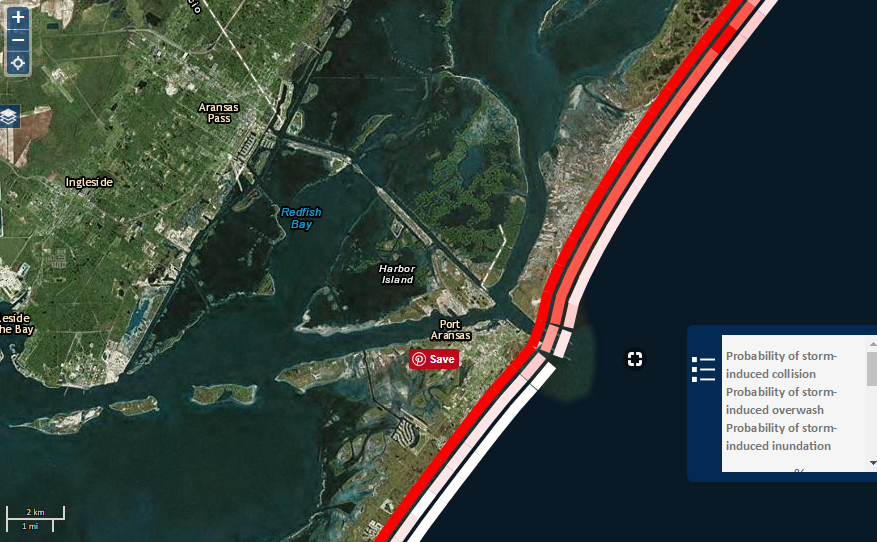
Below I zoomed in on an area near Corpus Christie Bay.


Area Near Corpus Christie Bay
Source: U. S. Geological Survey Coastal Change Portal
I'll added the link to my reference list.  You will find on the first page under the poll, surf and tides, and followers.  

This is one very useful tool.  You can watch it for future Florida coastal events.  

---

Source: nhc.noaa.gov

Unfortunately Harvey hasn't moved much yet.

The system out by the Canary Islands has a 90% chance of becoming a cyclone in the next 48 hours. It could be headed our way.


On the Treasure Coast we have a one to two foot surf.  The wind will be from the north this morning, shifting back to the south later in the day.  The tides are small now.

---

The blog poll is progressing nicely.  Almost 100 people have responded so far.  It would be nice to get that number.  Only a short time left to respond.

You might want to play around with the Coastal Change Portal a little.  I had some other things to post today, but decided to put them off for another day.

I was looking for an old find and ran across what appears to me to be a strange error coin.  I also found some other good web sites.

Happy hunting,
Treasureguide@comcast.net


Monday, April 20, 2015

4/20/15 Report - One Great Method For Locating Good New Hunting Spots And Some Things To Look For.


Written by the TreasureGuide for the exclusive use of treasurebeachesrport.BlogSpot.com.

View Of One Of My Best U. S. Silver Coin Areas Of the Past.
There are exciting ways to search for good new spots to hunt these days.  You might be able to discover some by searching through sites like Google Maps.  That will give you a view of places you might never see just driving down the road.

I chose a few spots that were among my favorites in the past to show as examples.  I think that will give you the idea.

The first  (shown above) shows one of my favorite silver coin hunting locations from the past.  This site was abandoned and overgrown when I hunted it.  There was a busy swimming beach there back in the days of segregation.  It was one of those "Colored Beaches."

The remains of the old wood groins is the first thing you might notice.  There were also abandoned buildings and an old parking lot behind the beach.

When I hunted there, which I did whenever the water eroded the dunes, I parked before going through he park entrance and walked down and around an old fence at the water's edge and up the beach to the groins.

Evidently people used to lounge on the dunes that were the covered with bushes when I visited the site.  Whenever the dunes eroded, silver coins in very nice condition would wash out.

Like many run-down abandoned areas, it used to draw its share of unsavory characters who would break into your car if they had a chance.

In more recent years the park has been revitalized. 

Gold Hunting Spot.
Here is another spot just around the corner from the one above.  You could either drive directly to this one or take a good walk from the first spot.  This spot didn't yield silver coins, but it was a good gold spot.  Even though it wasn't a well-known busy beach at the time, there were some bathers and wind surfers that visited the area.

The inside corner of the rock jetty shown above had a dip that yielded five gold rings the first time I ever visited that spot.  The sand and seaweed line in shallow water yielded a class ring.

People tend to stay more on the sand.  That makes narrow strips bordered by sea weed more productive.


Same Spot From Another View.
The arrow points to the same spot shown above.  I'm just showing how you can use tools such as Google Earth to check out potential hunting sites.

Recently I mentioned a carpet of silver that was found after Hurricane Andrew.  It was on the coral outcrop shown below.  The coral outcrop back then was normally covered by sand.  Hurricane Andrew removed the sand a left a bunch of coins and silver items.

The funny thing is, at that time I had never seen ANYONE there, but evidently some time in the past it was visited by more people.  I can understand why.  It is an interesting feature.

In recent years that constructed a path and a observation platform near that area.  You can see the rectangular platform in the picture if you look close.

Coral Outcropping

Around the bend from there is another place (See below) where silver coins were found as well as old bottles after Hurricane Andrew.

Another Silver Coin Spot Not Far From Coral Outcropping.
You can see the coral outcropping in this shot.  Near the road at the North end of the island you can see another silver coin spot.  It is right beside the where the road enters the island from the north.

I'm told that this spot is hard to get to now.  I was told that there is a fence there now that makes it difficult to get to from the road.

The laws might have also changed.  I don't know if you can detect there or not now.  The laws changed while I was down there.  At first you were not allowed to detect there and then you were.  I don't know if it has changed again or not.

My intent is not to show you particular spots to detect.  What I am showing today is that by browsing online sites such as Google Earth, you can get a good look at places and maybe find some nice new spots to try.  You can even use Street View to see how many people are at a beach and where they sit and swim.

Look for signs of old or abandoned structures or unique natural structures that might have drawn people in the past.  Always look for structures, man-made or natural, that can trap items.  Also where erosion might often occur.

-----

You couldn't ask for better water conditions for water hunting.  Only a one foot surf and a good negative tide!  You can get out there and not get jostled around.  The only trouble is the sandy conditions.  Expect a couple more days of that on the Treasure Coast.

Happy hunting,
TreasureGuide@Comcast.net

Thursday, May 29, 2014

5/29/14 Report - Tomoka's Golden Cup, Florida State Parks, O'Leno, Millions of Dollars of Gold Coins To Be Sold


Written by the TreasureGuide for the exclusive use of treasurebeachesreport.blogspot.com.

Removed Metallic Trash.
Found and photographed by Robert H.
 

Yesterday I wished I had a picture of all the trash that detectorists have removed from our parks and beaches.  Robert H. was quick to respond with what I'm sure is a very small portion of his share.

Pretty artistic, isn't it?  That is fit for a modern art gallery Robert.

That was fun, but I know Robert has treasure too, because if you remove all the trash you'll find some treasure and do a good deed in the process.


Here is more about the hunt for hidden envelopes of money.

http://xfinity.comcast.net/video/treasure-seekers-look-for-cash-filled-envelopes/269431875957/fanNews/newest/?cid=newsmod_sf_topic


I found this huge binder of Florida State Park information in a thrift store.  I bought it for a dollar.

Here is a map from one park.


Not only are there maps of the parks in the folder but also other information, including facilities and historical events that took place there.  And there is a lot of history at many of the State Parks.  Of course many are associated with forts, museums or battles.

Here is one paragraph found for Tomoka State Park.  

... This phenomenon occurred in the area of the last Timucuan stronghold as recorded in 1605 by Spanish explorer Alvaro Mexia. One folk story suggests a connection between the pink cloud and an Indian legend about Chief Tomkie who violated local religious practices by seizing a golden cup and drinking from a sacred spring that was said to have healing powers. Was this the Fountain of Youth? Anyway, this offense caused the surrounding tribes to attack Tomkie’s band. However Chief Tomkie was unhurt in the battle. Then a beautiful Indian maiden named Oleeta, drew her bow on the great Tomkie and put an arrow into his heart. She rushed forward and grabbed the golden cup from the Chief’s hand only to be struck down with a poisoned arrow. She was still clutching the sacred cup when she died. Legend has it that the golden cup is still in the possession of Florida Indians at the present time. Allegedly Chief Tomokie’s spirit was compelled to forever wander in the mists of the Tomoka River. I don’t know if the Pink Cloud has anything to do with this legend, but an unusual monument topped with a figure of Chief Tomokie can be seen at the Tomoka State Park in Ormond Beach.

Interesting legend!  I wonder if the golden cup can be found, or if it is fictional.

The maps in the binder were printed in 1972.  Some of the parks have changed since the maps were printed.  That is a good thing to look for on old maps -  where things used to be. 

Another good use for these maps, even though you normally can't detect in our State Parks, is to hunt the boundaries just outside of the parks.

One of the state parks is O'Leno State Park, which is where there once was a town that is no longer there.   If there was a town there at one time, undoubtedly there were areas just outside of the boundaries of the park where there was activity too.  Look for those areas.

Florida has a lot of things that you might not think of including, a waterfall, caverns, and a river that goes underground and then resurfaces again a good distance away.  The resulting natural bridge was used by Native Americans as long as they were there as well as the Spanish.

So keep your eyes open and you can find some good useful resources very inexpensively. 

Well, there are a couple of good hints and tips.


The California couple that discovered buried gold coins worth something like $11 million is up for sale.

http://abcnews.go.com/Weird/wireStory/california-couples-buried-treasure-sale-23885665


After today and tomorrow the surf on the Treasure Coast will start to increase.  If you are planning on water hunting, you might take advantage of the small surf that we have now.  Nothing else has changed lately.  We still have the southeast winds.


If you want your name included on the letter asking for PSL parks to allow metal detecting again, send me an email with your first and last name and Petition in the title.

Thanks to those who have already sent their name.

Happy hunting,
TreasureGuide@comcast.net


Friday, July 26, 2013

7/26/13 Report - 17th-century Wreck, Google Maps, Deep Water Wreck, CIA Museum, and Dorian


Written by the TreasureGuide for the exclusive use of treasurebeachesreport.blogspot.com.

Shipwreck Artifacts
Source: wtop.com

These artifacts include 17th-century Dutch paving bricks, cobble stones, 17th-century Sgraffito sherds, and pipe stems which were excavated from a shipwreck 10 feet deep in the St. Mary's River.

The ballast rocks are thought to be from England.

Here is the link to the photo gallery and more of the story.

http://www.wtop.com/?nid=864&sid=3400314&relgal=true#idx6


Crews from Google are now creating panoramic photo views of Florida's beaches that will soon be available through Google Maps.

Here is that link.

http://www.businessweek.com/ap/2013-07-24/floridas-beaches-to-be-available-on-google-maps#rshare=email_article


Deep Water Wreck
Photo: Noaa


A 19th century shipwreck found by the Shell Oil Company is said to be the deepest currently being excavated in US waters.  The wreck is 4,300 feet beneath the surface.  Artifacts and two other wrecks were found nearby.

http://news.nationalgeographic.com/news/2013/07/130725-shipwreck-gulf-mexico-19th-century-archeology-science/


NBC News reports on a secret CIA museum that you will probably never see.  The museum contains artifacts such as the AK-47 found beside Osama Bin Ladin when he was killed.

Learn more.

http://investigations.nbcnews.com/_news/2013/07/24/19562895-secret-cia-museum-features-osama-bin-ladens-ak-47?lite


Here you see the latest projected track for Dorian which brings it near the Bahama by Wednesday.

It does no appear to be strengthening.  As far as I'm concerned that is good.  It doesn't take a massive hurricane to improve hunting conditions.

On the Treasure Coast we still have winds from the west and very smooth seas.

At this point the surf web sites are not predicting any big surf with Dorian.  The only thing they are showing now is 2 - 4 feet by next Tuesday.  That isn't much.  Of course, things could change by then.

We've been having very smooth water and a nice low tides.  There have been a good number (not a huge number) of fossils seen on the beach fronts where there are shells.  William M. found sharks teeth on Hutchinson Island, and I saw some fossils, including a fossil horse tooth.

There have been a lot of salvage boats working lately.  I saw about a half dozen at one beach yesterday.

So right now with the current beach conditions, it would be very very unusual to find a shipwreck coin or cob on the beach, which makes the button I showed yesterday all the more unusual.  It is more likely that you will see conglomerates near the beach fronts.  And of course with the hot weather and smooth seas, the water is very inviting right now even though the shallow areas will generally be very sandy.


Happy hunting,
TreasureGuide@comcast.net

Tuesday, June 26, 2012

6/26/12 Report - Old Florida Maps & Tropical Storm Debby


Written by the TreaureGuide for the exclusive use of treasurebeachesreport.blogspot.com.

Antique Map showing Fort Capron and The Old Indian River Inlet
There are a lot of antique maps that can be found online.  This is a portion of a map showing the location of Fort Capron and the old Indian River Inlet.

The inlet shown here is now closed and is north of the present Fort Pierce Inlet and just north of the location of the Wedge Wreck.

The old inlet is also the area where the gold coins from the lost Fort Capron pay roll were found.

You can match up some of the islands and features on more modern maps and that will give you the location of the old inlet and fort.

Here is a link to the entire map as shown on the University of Florida map collection web site.


A few days ago I published a description of how James F. does research that helps him to find things like the steamboat strap that I also showed.  Old maps can be a nice part of any research effort.


Below is an old map of Cedar Key.  Isn't that a great example!  That type of image provides a 101 clues for detecting.


Old Map of Cedar Key


You can find the original digital image of this map on the same University of Florida web site listed above.  It has a lot of great detail.  Just plain fun to look at.

They have some other Florida maps that you might want to look at too.


The center of Tropical Storm Debby is near Appalachicola.   On the Gulf Coast Debby is producing rip currents and beach erosion with wind up to 50 mph.  Large waves with storm surges up to 5 feet are possible around  the area of Apalachee to Wacceasassa Bay.

On the Treasure Coast it is more south winds and rainy weather.  We're on the wrong side of this one.  Expect calm seas, down around one foot.  Of course that means no significant improvement in beach detecting conditions over here.

Here are a couple links for more details on Debby.


http://in.reuters.com/article/2012/06/26/usa-storm-debby-idINL2E8HQ0DF20120626


http://xfinity.comcast.net/articles/news-national/20120623/Tropical.Weather/?cid=hero_media


Happy research leads to happy hunting.


Happy hunting,
Treasureguide@comast.net

Wednesday, March 23, 2011

3/23/11 Report - Maps and More Maps


Fort Capron Map.

I have some things to catch up on today. I've had so much to write about that sometimes I forget some things or they simply get delayed.

As you probably know, I did a series of posts on Fort Capron and the Fort Capron treasure. The upcoming Sedwick Coins auction will include coins from that treasure.

In the recent past I posted maps showing Fort Capron. One of the maps was a map from 1855. Brad C. submitted the above map. As you can see, he marked the spot where Fort Capron is often shown on maps and also where he puts the actual location.

Thanks Brad!

I posted about the Fort Capron treasure partly to encourage you think about sources of treasure on the Treasure Coast in addition to our well-known 1715 Fleet.

I also hope the Tequesta article that I posted broadened your perspective on other treasures in Florida.

I also recently posted some resources for finding maps that might be helpful. Scott B. sent in some more that I'll list here along with some of his notes.

* Perry-Castañeda Library Map Collection (free) -http://www.lib.utexas.edu/maps/topo/florida/

* Landsat.com (you must pay for these) - http://www.landsat.com/usgs-topo-maps/florida-topos/#6

* USGS will research their hardcopy map library and make a black-and-white copy for you (must pay) - http://egsc.usgs.gov/isb/pubs/factsheets/fs15499.html

* The USGS store (free and pay) - you can zoom to your area of interest and place a point, then click on the point and it will list what they have available. See the following example of Wabasso Beach. They have a 1970 map of the area you can download and view in Adobe Reader - http://store.usgs.gov/b2c_usgs/usgs/maplocator/(xcm=r3standardpitrex_prd&layout=6_1_61_48&uiarea=2&ctype=areaDetails&carea=%24ROOT)/.do

* The National map - not so much historical maps, but current imagery and you can overlay the topo maps and view both - lots of good information; take a look near South Beach Park (?) using the geo coordinates 27.64117 and -80.35051 - note the underwater sandbar stretching from the beach out into the water, could be useful to know. - http://viewer.nationalmap.gov/viewer/

* And your local library probably has copies of the old USGS maps in their research section. You usually can't check them out, but you can make copies.

Don't say you never get anything free. That is some useful information.

Thanks Scott!


And here is an article on how some of the tree islands in the Everglades may have formed. It could be that they were formed on Precolumbian trash dumps.

http://www.eurekalert.org/pub_releases/2011-03/agu-ath032111.php

You can sometimes find old sites by looking at differences in the current vegetation. Google earth and other viewers can be useful in identifying sites like that.


And a 10.000 year-old spear was recovered from a deep spring in Florida. Although I don't always agree with the dating techniques, this is a good article that you might want to read.

http://www2.tbo.com/content/2011/mar/18/182053/scientists-bring-10000-year-old-spear-in-spring-to/


It's foggy this morning. It reminded me of the time I was doing some shallow water hunting and I couldn't see but a few feet around me in any direction. Standing out there in a flat quiet ocean with just white all around was a sight to behold. Some of the most amazing and beautiful sights that I can remember seeing, I saw while shallow water hunting.


Forecast and Conditions

The wind is out of the west and the sea is calm. It looks like we'll have calm seas for at least a few days. That makes for easy water and low tide hunting.

You might want to check out some of those low tide zones this week. The tides are still pretty good.

That is about all I have time for today.


Happy hunting,
TreasureGuide@comcast.net