Showing posts with label dunes. Show all posts

Monday, May 25, 2020

5/25/20 Report - Coastal Range Monuments and Changing Treasure Coast Beach Profiles. Mystery Find. Snoop Drone.


Written by the TreasureGuide for the exclusive use of treasurebeachesreport.blogspot.com.

Turtle Trail Coast Line With Survey Monument Markers Identified.

There are range monuments all along our coast.  Maybe you've seen some of them.  They have brass caps with location information on them.  The one at John Brooks beach is just to the right of the walkway near where the walkway opens to the beach.  I think you might be able to see it now.  It has been uncovered for a while but could have been covered again.

The above map shows the location of the range markers along the Turtle Trail area.  The Turtle Trail parking lot is between markers R-51 and R-52.  R-52 is south of the parking lot.

The following shows the beach profile at R-52 on Nov. 1972 (blue) and Sept. 2007 (green).


The waterline in 2007 at the mean high water was about fifteen feet farther out than in 1972, but at mean low water, due to the more gradual slope, the water line was thirty feet or more farther out than the 1972 water line.

Here is a closer view so maybe you can see it a bit better.


Of course the slope of the beach is not as steep as it appears in the illustration.  Each square represents fifty feet.

Notice how the 1972 profile has a steep front slope and drops off quickly in the water.  The 2007 profile, on the other hand has a lot more sand in the shallow water.  Because items in shallow water were covered by less sand in 1972, the likelihood of items being washed up onto the beach would be greater at that time, although they could also get pulled back into the water more quickly due to the steeper slope.

Here is what the beach in front of the R-52 monument looked like last Thursday - gradual slope with only some of the renourishment sand remaining at the dunes.


Just South of Turtle Trail Thursday Near Low Tide.
You can see the face of the dunes and the white renourishment sand from the last renourishment project at the back of the beach.

Here is an illustration showing various beach profiles at R-13 for seven different times between 1999 to 2008.  R-13 is a little less than about halfway between the Ambersands beach access and the McLarty Museum.

Frances and Jeanne hit us in September of 2004.  You'll notice a profile taken in August of 2004 (before those storms) and in October of 2004 (after Frances and Jeanne).

On the beach front it looks like the beach was cut back around ten feet after the storms.  But remember by that time some refilling had already happened.  The biggest difference between the August and October profiles is closer to the dunes.

You will see a bump in the October profile about 40 feet back from the waterline, that would probably where a lot of the sand that washed back in piled up forming a new berm.

In the five to ten foot elevation range, the June 2003 profile shows the beach being higher than it was during both before and after 2004 storm profiles.

The July 1999 profile shows the beach front at that location eroded farther back than at any other time.  I would expect the best metal detecting around July 1999 and January 2003.  The front beaches were eroded back and the shallow water had less sand close in.

There is a lot you can learn from these beach profiles, but it helps to know when the beaches were renourished and when major storms occurred.

I could go on for a long time about this type of data, but I'll leave that to you if you are interested.

You can use this link, which was sent to me by DJ.

https://www.ircgov.com/Departments/Public_Works/Coastal_Engineering_Section/Documents/Sector_3_Environmental_Assessment.pdf

Besides the beach profiles you'll find a lot of other information about the beaches and the renourishment projects.

Thanks DJ.
---


Bill M. sent me the following.

On Friday I spent most of the day detecting Amber Sands beach.  Going north about a mile, I got into the area where there are lots of iron flakes.  Going further north, I found the item below.   


Mystery Object
Find and photo by Bill M.


It rang up as metal, is only slightly magnetic, is heavy at 9.3 grams, and has what looks like flakes of metal in it.   I've been detecting for years and never found anything quite like it.


As I was working my way back to the stairs, I noticed a large shadow in front of me.  I thought it was a bird, but it seemed to be following me.  I looked up and there was a large drone hovering about twenty-five feet above my head.  It was much larger than a DJI Phantom and had a glass dome over the camera.


I couldn't see anyone nearby operating it but did notice a salvage boat offshore.  I wonder if they were the ones who launched it.


Two mysteries in one day!


What do you think of Bill's mystery find?   An EO perhaps?

---

A person wearing a facemask on a wide open beach might at least be reducing the risk of skin cancer.


If you believe Governor Cuomo, the exaggerated and  inaccurate predictions of the IMHE model and agencies were responsible for a good number of the coronavirus deaths in New York.  He said it was because of the dire predictions of an over-whelmed health care system that he demanded the nursing homes accept infected seniors, and that is precisely where a big percent of the deaths occurred.


Expect a two to four foot surf along the Treasure Coast for the next week or so.


TreasureGuide@comcast.net


Thursday, February 27, 2020

2/27/20 Report - Cuts and Eroding Beaches That Expose Treasure. Photo Comparison. 1715 Fleet Silver Rings.


Written by the TreasureGuide for the exclusive use of treasurebeachesreport.blogspot.com.

Seagrape Trail As It Looked Last Saturday

I distinctly remember watching Monday Night Football maybe thirty years ago when Howard Cosell commented to Dandy Don, "You have a tremendous grasp of the obvious."  It was meant as a humorous insult, but it strikes me now as something of a complement.  Advances in understanding are often made painfully slowly and often involve gaining a deeper appreciation of what was hiding in plain sight all along.

Were you ever metal detecting when a surprise wave hit you and almost knocked you off your feet?   It has happened to me numerous times over the years.   In fact I remember once actually getting knocked off my feet.  Inspiration can come with a sudden rush too.

I've talked a lot about the importance of what I call cuts.   If you looked at some of the beaches that were eroded last week, you might not have noticed any cuts, but there were cuts.  Those cuts were very high though.  The face of the dunes was cut.  At the bottom of the dunes you could see a layer of black sand over a layer of the old orangish sand exposed in some locations.

It is not often that we get a surf of over ten feet, but that happened on the Treasure Coast in both January and February.  And shipwreck treasures were found both times.

On the 22nd the high tide was bouncing off of the dunes, and the water was rushing with good force back down the slope carrying sand and other materials with it.  You can see from the photo above where probably two feet or more of sand was removed.  Old wooden posts that were previously buried were exposed, and stairs were left hanging two feet off the ground.

If you take a volume of sand two feet deep by maybe thirty by fifty yards, that is a volume of 3000 cubic yards of material being classified.  That can easily happen in one six hour tidal period, and that is undoubtedly a small part of what actually happened on the beaches that day.

So what is it about cuts that makes them so significant to the beach detectorists?  I mentioned it above.  When the water hits the face of a cut, or dune, the water rushes back down the hill with a lot of force.  If you get caught in it, you can feel how strong the flow is.  There are times when it can knock you off your feet.  That is obviously strong enough to carry sand - and other materials with it.

Yesterday I talked about the amount of water velocity required to suspend different kinds of particles and objects, and the amount of force required to transport those objects.  When the force decreases below the amount required to transport objects, they drop out and settle.

My main point today is that even though there weren't any obvious cuts on the slope of the beach last Saturday, there were cuts to the dunes at the top of the beach, and at high tide the water was bouncing off the face of the dunes and flowing down the slope, carrying sand and other objects until the flow slowed enough to drop whatever objects were being carried.

If you look at the photo above, the yellow line runs parallel to the beach.  There is something of a momentary dead spot.  The incoming water hits the water rushing back down the slope there.  But that is only momentary, as the next wave is already on the way.

Obviously that area will move as the tide comes in and goes out.  It proceeds up the hill towards the dunes during the incoming tide and then recedes down the slope and out as the tide recedes.

The red line shows how much sand has been removed from under the steps.

Compare these two photos.


It is always handy to have more than the most recent photo.   Old photos give you a base line.   You can compare different times and see what is happening.

If I know a beach is especially high, for example, then I know it will take more weather and erosion to make it productive.

The fluctuation on a beach is seldom two feet or more over a wide area.  Down at Turtle Trail, when the sand is low you can see a foot or so of the blue bags, but when the sand is high they are covered again.  There are posts down there that also appear and disappear.

Notice  the foot of the dunes and the slope right in front of the dunes in the last photo.

Thanks to DJ for those photos.

---

Silver Finger Rings From the 1715 Fleet.

One of the most experienced Treasure Coast salvage divers said that no silver rings have been found on 1715 Fleet wrecks.  That is something that has interested me for a number of years, especially because of how commonly old silver rings are found on the wreck beaches.

I know of three examples of documented silver rings that have been correctly or incorrectly attributed to the 1715 Fleet.  That is such a small number that even if they are all correctly attributed, they are undoubtedly personal property rather than cargo.

Below are those I have seen listed as being from the 1715 Fleet.

1.  In Artifacts of the Spanish Colonies of Florida and the Caribbean, 1500-1800, Vol. 2: Portable Personal Possessions, by Kathleen Deagan, a silver Claddagh ring shown on page 126 is attributed to the 1715 Fleet.

2.  In the Winter Beach Salvage Camp, by Doubglas R. Armstrong (2012 revision), on page 52 a gold plated silver ring is attributed to the 1715 Fleet.

3.  And just this year, VeroNews reported that West Bay Trading Company certified a silver ring found by Jeff Emlet on a Vero area beach as being from the 1715 Fleet.  See my 2/6/20 post, https://treasurebeachesreport.blogspot.com/2020/02/2620-report-first-silver-ring-beach.html, for more information about that.

Without some type of specific markings and historical documentation, I do not know how you could tell that an isolated ring find would be from a particular fleet or wreck rather than from some other source, including, for example, contemporary salvage efforts.

In any case, I'd like to keep a list of silver rings attributed to the 1715 Fleet.   If you know  of any others, I'd like to add them to my list.  Please be specific about the source of information.

---

Despite the most recent cold front, we're supposed to have nothing higher than a two or three foot surf for the next week.

Happy hunting,
TreasureGuide@comcast.net


Tuesday, January 7, 2020

1/7/20 Report - Beach Reports and Photos. Beach and Coin Layer Diagram. Falcon 9 Launch.


Written by the Treasureguide for the exclusive use of treasurebeachesreport.blogspot.com.


Frederick Douglass Beach Monday Morning
Photo by Steve M.
Steve M., who visited Turtle Trail and sent photos to the blog Sunday, visited Frederick Douglass beach yesterday and sent photos and the following report. 

My wife and I went to Douglas beach about 9:30. Hadn’t been here in weeks so not sure how it has changed. An old cut about 4 foot.High tide hits it. Mostly trash and modern coins. Surf is 3 foot and calmer winds today. Real nice cool day.


Frederick Douglass Monday Morning
Steve M.
You can tell a lot from the photos.  Notice the convex beach.  That is not a good sign.


Frederick Douglass Beach Monday Morning.
Photo by Steve M.
Also notice all the little shell pieces.


Frederick Douglass Beach Monday Morning.
Photo by Steve M.

Alberto visited Turtle Trail yesterday (Monday).  Here is what he said.

Read today's post and saw the photos by Steve M. I stopped by TT on Sunday afternoon and saw the cuts and figured maybe Monday early am they might be better, didn't happen like I thought see attached photos. There were 3 other detectorist already hunting at 8 am. I tried but nothing. 


Turtle Trail Monday
Alberto S.

Cuts on the front of the beach like that show very little sand being moved -  It is just a little stirring of sand on the front beach.

Seems like a good time to look at a simplified beach diagram.

Here is a diagram of a beach having high dunes at the back and a flat beach in front of that, which then slopes down into the water.

In relatively calm surf, you have small waves that vary little from the water's surface.  A small cut might be created as shown above.  In that case, the water simply moves a little of the sand down the slope a little way.

The red areas are where the layers of older coins are in this case.  There is a layer from contemporary salvage efforts in the dunes, typically buried about two feet.  A layer under the back beach, which could be deposited either by coins eroding out of the slope at high surf or being washed up during high surf and erosion.  That layer can be changed from time to time as erosion occurs and then the layer is covered again.  Then there is the deepest layer near bedrock, which was exposed during extreme conditions in the past.

For the layer in front of the dunes to be uncovered the erosion has to be farther back than the erosion shown in this diagram.  Coins can end up on the surface when the back dunes erode too.  High surf can undercut the dunes and coins slide down onto the beach, where they can stay until the get covered again.  They can also be swept out into eroded areas on the front beach.

The coins at the deepest layers have to be uncovered before they can be washed up onto the beach.  The amount of sand in the water is important, because it protects those layers and protects the beach.

I just wanted to show that the majority of the time, the various layers of older coins and things are covered.  It takes a good bit of movement to uncover the coins in the water so they can be washed up.  It also takes erosion moving back and deep for mid-beach layers to be uncovered.  And it takes the water eroding the dunes for those coins to reach the beach.

Most of the time the water is only moving the same old sand in and out in the most active area and not affecting the old coin bearing layers at all.  Notice that the green area where the most movement of sand occurs does not touch any of the coin layers (red).

I think the diagram shows something like what was seen at Turtle Trail the past couple of days.

Of course the diagram is a crude oversimplification, but I think it might still help a little.

---

The 9:19 PM Falcon 9 launch from Cape Canaveral was very brightly seen over the Treasure Coast last night.   I saw it, as did my 93 year old mother, who reminisced about how as a child she used to marvel at any airplane flew over their rural area.

You can see many nice photos and articles about the launch online.

https://www.floridatoday.com/story/tech/science/space/2020/01/06/spacex-vaults-falcon-9-to-orbit-from-cape-canaveral-with-60-more-starlink-satellites/2826868001/

---

Today the surf is still small on the Treasure Coast.  Thursday and Friday it might be more like 4 - 7 feet.

Happy hunting,
TreasureGuide@comcast.net


Friday, September 6, 2019

9/6/19 Report (Part 2) - Indian River County Beach Accesses. More On Cuts.


Written by the TreasureGuide for the exclusive use of treasurebeachesreport.blogspot.com.

Yesterday I posted a list of beach accesses that were closed in Indian River County as of 8 to 9 AM.  It seems some might have been opened later.  It appears that there was a precautionary swimming advisory due to bacteria in the water, which might have been one reason for some of the beach closings.  As you'll see below, one person was told that beach closures might be due to damage to the beach access(es).  I don't know which, if either of those, or if both were responsible for the closures, but it seems that some of those beach accesses, if not all, will be open on Saturday.

The most recent email I received concerning the Indian River County beach closings is from DJ.  It  follows.


I received this text an hour ago: "S: Indian River County beaches have been tested and determined to be satisfactory for swimming.


The Florida Department of Health in Indian River County is lifting the county wide precautionary swimming advisory that was posted on September 4, 2019 for all public beaches.”


If some beaches were closed because of bacteria, I suspect thoe will be open tomorrow.

Before DJ's email I received the following email from Jerry P.

Just wanted to let you know how much I appreciate your daily blog reports. Especially in times of big wave and sand movement. Your 5th picture on 9/4 was actually me. I had just hit the beach at John Brooks heading north for a short ways before turning south. I went about a mile south working upper and lower wet-sand areas. Even gridding a few spots from the water line up to the dunes that looked promising. Only found a few clad and lots of can slaw.


On the way home to WPB I made a recon of most of the accesses north all the way to Melbourne for the next day’s trip. I saw the same thing you saw today in Vero Beach. ALL the beach accesses were gated, and Turtle Trail as well as Sea-Grape had Vero Officers in Black SUVs stationed in front of the gates. Makes no sense to me to waste that amount of manpower guarding beach accesses when the conditions were not dangerous at all. And this was around 2:30 pm on Wednesday!


Yesterday 9/5, I did notice that Golden Sands gate was open, but all others all the way to Amber-Sands were locked. No cops this time though. Today they were saying that the water quality was not fit for swimming in Indian River County. That may be the reasoning for gating them. But seams to me there must be other motives with Officers stationed at the gates again, since we can’t go it the water anyway😎

And before that I received this message from Joe D.

  I just got off the phone with parks dept of IRC! They said only beaches open were Golden Sands, Wabasso, Round islsnd, and Tracking Station! 


    I was told that the others had  possible access damage! I told her that detectorist were not concerned about that, and that we just wanted the parking to access the beaches! She said she would check again!  


   I would suggest flooding them with phone calls to speed up the process and let them know that we are watching and waiting!!


(772) 567-8000 main number! Ask for Parks Dept. They will transfer; or get direct number!! 


What I found at 8 or 8:30 AM Friday does not match entirely with the beach accesses being either open or closed later, so it sounds as if some beaches were opened after I was there.

---

Not all cuts are the same - not even if they are the same size.  It is very important what the erosion cuts into.  If it cuts into old sand, that is good.  However if it cuts into new sand, it generally isn't worth much.

The cuts I showed  in the last couple of days were just eroded dunes that had been created in recent years.  Nothing old is going to be in those dunes, and nothing old is going to get washed out of them.  People were finding modern coins and aluminum below those cuts.

You can have a big cliff cut into the dunes.  That still won't yield much of anything old IF the cliff is in new sand, such as beach renourishment sand.

Some people saw some big cuts in renourishment sand that was dumped on the beach just a year or two ago and got excited.  Nothing old is likely to come out of sand like that unless something old was in the sand when  it was dumped there.

One other exception would be if the cliff was big enough and things washed up and got dumped in front of the cliff.  That would not be too likely at most of our beaches now.  When that happens, you'll probably have some good solid packed sand in front of the cliff.  That is not what we have at most of our beaches now.

---

I wanted to get what I learned about beach accesses posted earlier enough for you to take it into account for the weekend.  Therefore I'm posting this part of my 9/6 post early.

I might have more to add to it later.

Happy hunting,
TreasureGuide@comcast.net


Sunday, August 4, 2019

8/4/19 Report - Gold Shipwreck and Beach Nuggets. Two Kilogram Nugget Found. Killed by Falling Beach Dunes.


Written by the TreasureGuide for the exclusive use of treasurebeachesreport.blogspot.com.


Three people were killed when a dune collapsed,

I've seen similar dangerous conditions on the Treasure Coast.  There was one beach a few years ago that was very dangerous. Be careful when working next to a high cliff.  Heavy slabs can fall off without warning.  

Here is the link for more about the incident.


---

On 7/31 I posted some of the most recent 1715 Fleet finds.  Included was a group of gold nuggets from Rio Mar.  

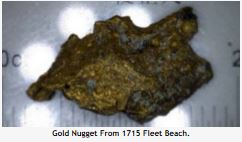
I found at few gold nuggets at John Brooks.  The largest, and the one that I posted before, is shown below.  It was found near three other smaller ones.  I didn't find any other old items that day.

Photo by TreasureGuide
As you can see, this one is sharp, and maybe you can not see it as well, but it has a good bit of quartz on it.  I should get a better photo of it sometime.  Being so sharp and angular, it doesn't look like placer gold.

The nuggets from Rio Mar that I showed in 7/31 are similarly angular, but I don't see any evidence of quartz.

Photo submitted by JaminJackUSA.

A search of the Mel Fisher artifact database, shows a lot of nuggets, but all of those in the database came from the Margarita and Atocha sites.  I did not find any in the database from the Treasure Coast.

I'd like to see photos of other gold nuggets from Treasure Coast shipwrecks or shipwreck beaches.

Rio Mar has long been known as the primary site on the Treasure Coast for nuggets and fine gold - some of it too fine to be easily collected.

I've also posted some possible nuggets that could be dental gold or other miscellaneous melted bits that are difficult to identify as being wreck related, such as the one shown below that was found by Duane C. 


On the subject of gold nuggets, here is a good story.

A Victorian retiree has struck gold, unearthing a 2-kilogram nugget worth about $130,000 on the outskirts of the gold rush town Ballarat.

The amateur prospector was searching through old pastureland in a now 'top secret' location when his metal detector started beeping.


He started digging and quickly uncovered a .22 lead bullet.

Thinking that was that, he was about to move on — but his detector was "insistent" there was something else further down.

Located under 30 centimetres of wash under about 15 centimetres of clay was the whopping gold nugget, which has since been named You Wouldn't Believe It... 

Here is that link.


---

We are still having nice big tides, but little surf on the Treasure Coast.

From the National Hurricane Center:

A westward-moving tropical wave located about 300 miles east of the
central Lesser Antilles continues to produce an area of cloudiness
and thunderstorms. Environmental conditions are forecast to become
less conducive during the next couple of days, and significant
development of this system is not anticipated.

* Formation chance through 48 hours...low...10 percent.
* Formation chance through 5 days...low...10 percent.

I'd still keep an eye on that one.  It has plenty of time yet.

Happy hunting,
TreasureGuide@comcast.net

Friday, March 8, 2019

3/8/19 Report - High Tech Tools For Scouting Metal Detecting Sites.


Written by the TreasureGuide for the exclusive use of treasurebeachesreport.blogspot.com.

Turtle Trail Area.
Photo by Alberto S.

That is a great photo. Alberto S. took these beach photos. Here is what he said.

Flew my drone yesterday at Turtle Trail, one detectorist was hunting south of the entrance and another one was going north. Before I left I had a chance to talk with the fellow that was hunting south and he said he didn't even dug a single hole. More were arriving, I guess the expectation was that the beach would show some erosion based on the recent front but that did not happen. I flew the drone along the coast going south since there was no one on the beach but did not see any conditions that were different from where I was. It was a beautiful day!

South of Turtle Trail Access.
Photo by Alberto S.

North of Turtle Trail Access.
Photo by Alberto S.
Thanks for the report and super photos Alberto!

---

Dale J. has been using Google Earth in a way that you might want to consider.  Here is what he said.

This is new to me but I use Google earth to figure how far I need to walk to some areas. So I use the Line Measure tool. But found if I save the line, then right click it, a menu appears. One choice I never noticed is called “Show Elevation Profile”.

I shows the profile of what is under the red line, in this case the beach profile when the most recent photo was taken. These two [ I only posted one. TG ] were in Jan 2018.

Not real time of course but interesting to compare beaches. Too bad it won’t work going back in time... It really would be nice to be able to see the changes in elevation.


Here is an example that Dale sent.


Image Showing Line Tool and Elevation Using Google Earth.
Submitted by Dale J.
In this example the elevation from dunes to the end point is a decrease of 15.4 feet. Thanks Dale. That could be real useful. There are two types of beaches we have on the Treasure Coast. There are those with a cliff at the back of the beach, such as Wabasso or Turtle Trail, and those that have lower dunes, such as John Brooks. Those with a cliff at the back tend to be narrower beaches. The narrow high-dune beaches can be replenished with old items that wash out of the dunes. The dunes on the narrow wider beaches seldom erode. That means that the old coins that appear come from the water or layers of sand that haven't been exposed for a while. Both of those can happen at the narrower beaches too, of course. Since our Treasure Coast beaches generally move west, as the wind blows sand back and builds new dunes. the dunes move back and fill in the marshes. --- When guys submit good information like Alberto and Dale did today, they are helping you. It isn't something they have to do, but they are being generous. When you benefit from their work, let them know. --- There are no significant changes in beach conditions. Just another beautiful day. Happy hunting, TreasureGuide@comcast.net


Sunday, February 11, 2018

2/11/18 Report - Everglades Treasures and Treasure Coast Burial Site: Ole Timer Talk.


Written by the TreasureGuide for the exclusive use of treasurebeachesreport.blogspot.com.

John Brooks Beach Saturday Afternoon.
It is a beautiful weekend. I don't think I ever saw more people on the beaches around Fort Pierce.  The Fort Pierce beach parking lots were jammed.  There should be some new modern items out there after all of the beach traffic.

What a beautiful joyful Sunday morning!

---

Yesterday I posted some of Southern Digger's email to me.  Today I'll post more of the same email.  It tells about a large collection of silver coins obtained from Florida Everglades sites.  Here is what he said.

: ... That collection filled about fifty 8 X 12 inch Riker cases. The viewing was so private that I was not allowed to note the address or location and I was never given the names of the collection owner. That did not bother me. Just to view and study it was a vast education which helped me in later years on seeking sites in the deep woods of the everglades--that is, on privately owned land. 

I know the collection I saw came from lands now under state and Federal laws and are off-limits. Moreso, I have heard that people who ignored these boundaries were arrested; severely fined; and, sometimes imprisoned for trespassing and digging these sites. I won't go into detail how the collection was obtained, but it involved the Caloosa Indians, Mendenez's Gold, and later European contact which evidence showed was on wild and hidden places of tribal ceremony -- I might add, on land which had not enforced government restrictions at the time it was discovered. 

In fact, when young and hunting in the glades it was not uncommon to enter a hammock from five to twenty miles from the nearest dirt access road and find a cabin and a few occupants living free off the land. Maintaining food from gardens and hunting; and, water from makeshift cisterns. The Federalization of the Big Cypress and other parts of the everglades ended this by the late-1960's.

The collection included finds that dated from early European contact--including rare glass beads which were identified to date back to Portugal from the fourteenth century; it contained gold beads up to 3/4" long and 1/4" or thereabouts diameter. Some silver coinage was hammered into breastplates with stick-figure artwork of deer being chased by stick figure Florida Indians pursuing the game. On some of these, you can still make out the stretched/hammered outline of the original coin enought that you could determine what type of coin was used to make it. I recall being bold enough to ask if I could photograph at least part of the collection, but of course, was refused. 

This treasure was not obtained from one site--but rather from several sites and much hard work and much time camping in the glades away from the comforts of society. Referring back to the coins--I saw they were of Spanish. English and American origin--the latest dating to the 1830's indicating Seminole and Spanish Indian influence and use of sites which date back to pre-Mendez era and of course, prehistoric. Most likely, some of these items were obtained from beached shipwrecks and shipwreck survivors. Many of the coins were in part defaced. Scratch marks in the head of Liberty or the King, which indicate hatchet marks; and scratches on the throat indicating the obvious.

Southern Digger also emphasized that there is a lot that was not reported and much of what is published is often twisted.

On the question of 1715 Fleet burials, which I've mentioned a few times recently, Southern Digger said,  At the Disney site on the Treasure Coast--before the structures were built--was a raised dune near and just north of the old beach access. When that was scraped back by construction, an archaeologist representing Disney stated to me that they found a grave which was believed to be a shipwreck victim as they recovered a ring with it. Also, they found an anchor in the dunes. Of course, I did not know the source and just regarded it as here-say. Perhaps research of published State records can prove such finds were actually recovered.

Southern Digger has long been involved in South Florida archaeology.  Thanks for sharing S. D.

---

The wind picked up Sunday morning, but was coming from a southerly direction.  Everything else is pretty much unchanged.  The tides will increase a little again in a few days, while the surf continues to run around two to four feet.

May you find peace within,
TreasureGuide@comcast.net