Showing posts with label renourishment. Show all posts

Monday, May 25, 2020

5/25/20 Report - Coastal Range Monuments and Changing Treasure Coast Beach Profiles. Mystery Find. Snoop Drone.


Written by the TreasureGuide for the exclusive use of treasurebeachesreport.blogspot.com.

Turtle Trail Coast Line With Survey Monument Markers Identified.

There are range monuments all along our coast.  Maybe you've seen some of them.  They have brass caps with location information on them.  The one at John Brooks beach is just to the right of the walkway near where the walkway opens to the beach.  I think you might be able to see it now.  It has been uncovered for a while but could have been covered again.

The above map shows the location of the range markers along the Turtle Trail area.  The Turtle Trail parking lot is between markers R-51 and R-52.  R-52 is south of the parking lot.

The following shows the beach profile at R-52 on Nov. 1972 (blue) and Sept. 2007 (green).


The waterline in 2007 at the mean high water was about fifteen feet farther out than in 1972, but at mean low water, due to the more gradual slope, the water line was thirty feet or more farther out than the 1972 water line.

Here is a closer view so maybe you can see it a bit better.


Of course the slope of the beach is not as steep as it appears in the illustration.  Each square represents fifty feet.

Notice how the 1972 profile has a steep front slope and drops off quickly in the water.  The 2007 profile, on the other hand has a lot more sand in the shallow water.  Because items in shallow water were covered by less sand in 1972, the likelihood of items being washed up onto the beach would be greater at that time, although they could also get pulled back into the water more quickly due to the steeper slope.

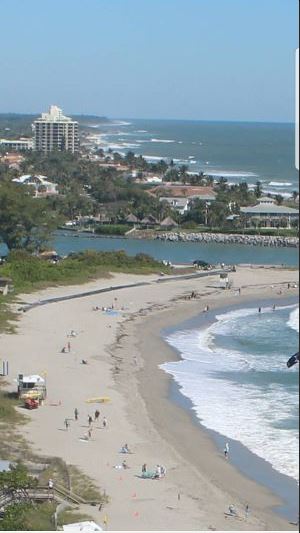
Here is what the beach in front of the R-52 monument looked like last Thursday - gradual slope with only some of the renourishment sand remaining at the dunes.


Just South of Turtle Trail Thursday Near Low Tide.
You can see the face of the dunes and the white renourishment sand from the last renourishment project at the back of the beach.

Here is an illustration showing various beach profiles at R-13 for seven different times between 1999 to 2008.  R-13 is a little less than about halfway between the Ambersands beach access and the McLarty Museum.

Frances and Jeanne hit us in September of 2004.  You'll notice a profile taken in August of 2004 (before those storms) and in October of 2004 (after Frances and Jeanne).

On the beach front it looks like the beach was cut back around ten feet after the storms.  But remember by that time some refilling had already happened.  The biggest difference between the August and October profiles is closer to the dunes.

You will see a bump in the October profile about 40 feet back from the waterline, that would probably where a lot of the sand that washed back in piled up forming a new berm.

In the five to ten foot elevation range, the June 2003 profile shows the beach being higher than it was during both before and after 2004 storm profiles.

The July 1999 profile shows the beach front at that location eroded farther back than at any other time.  I would expect the best metal detecting around July 1999 and January 2003.  The front beaches were eroded back and the shallow water had less sand close in.

There is a lot you can learn from these beach profiles, but it helps to know when the beaches were renourished and when major storms occurred.

I could go on for a long time about this type of data, but I'll leave that to you if you are interested.

You can use this link, which was sent to me by DJ.

https://www.ircgov.com/Departments/Public_Works/Coastal_Engineering_Section/Documents/Sector_3_Environmental_Assessment.pdf

Besides the beach profiles you'll find a lot of other information about the beaches and the renourishment projects.

Thanks DJ.
---


Bill M. sent me the following.

On Friday I spent most of the day detecting Amber Sands beach.  Going north about a mile, I got into the area where there are lots of iron flakes.  Going further north, I found the item below.   


Mystery Object
Find and photo by Bill M.


It rang up as metal, is only slightly magnetic, is heavy at 9.3 grams, and has what looks like flakes of metal in it.   I've been detecting for years and never found anything quite like it.


As I was working my way back to the stairs, I noticed a large shadow in front of me.  I thought it was a bird, but it seemed to be following me.  I looked up and there was a large drone hovering about twenty-five feet above my head.  It was much larger than a DJI Phantom and had a glass dome over the camera.


I couldn't see anyone nearby operating it but did notice a salvage boat offshore.  I wonder if they were the ones who launched it.


Two mysteries in one day!


What do you think of Bill's mystery find?   An EO perhaps?

---

A person wearing a facemask on a wide open beach might at least be reducing the risk of skin cancer.


If you believe Governor Cuomo, the exaggerated and  inaccurate predictions of the IMHE model and agencies were responsible for a good number of the coronavirus deaths in New York.  He said it was because of the dire predictions of an over-whelmed health care system that he demanded the nursing homes accept infected seniors, and that is precisely where a big percent of the deaths occurred.


Expect a two to four foot surf along the Treasure Coast for the next week or so.


TreasureGuide@comcast.net


Tuesday, February 4, 2020

2/4/20 Report - Monitoring Cleaning of Silver Reale. Beach Conditions: Short Term and Long Term.


Written by the TreasureGuide for the exclusive use of treasurebeachesreport.blogspot.com.

Four Reale After Cleaning and A Little Polishing.
I've been showing the progress as I clean a recently found four-reale.  I showed a few photos of that previously, including how it looked when it was found and how it looked after a little cleaning.

I cleaned that cob some more, and you can see above how it looks now.  I'm done with the Muriatic acid.  The encrustation has been removed, and I did just a little shining with a baking soda paste.

The details can be seen much better now.  I'm pretty sure that it is a Phillip V and dates to between 1700 and 1715.

Below is a close-up like the one I showed just a few days ago when I was not done with the cleaning.  If you compare this photo with the one I posted the other day, you'll see how much of the encrustation and foreign particles have  been removed by soaking in Muriatic acid.  You can also see how the high areas that have been shined actually look like silver now.

Close-up View of Part of the Same Four-Reale.

I also stumbled onto something else that might be helpful.  If you want to get a better look at the design before you are done cleaning it, you can use some wet baking soda spread thinly across the surface of the cob to bring out the design, as shown below.


Same Four-Reale With Baking
Soda Bringing Out the Detail.

With just the naked eye I could see the details of the design probably better than I could see it with magnification but without the contrasting white substance.  I was really surprised by how much it helped.  I took the above photo with a regular digital camera.  I probably should have used magnification so you could see the effect even better.

---

Steve and Paulette M. sent the following email and photos take yesterday (2/3) and commented on Bonsteel where the cliff in front of the dunes is about six feet high.  Below is the photo and email.

Bonsteel Park 2/3
Photo by Steve and Paulette M.
Today we were looking at different beach accesses north of Fort Pierce and we started at Indialantic and went South to Turtle trails.  Not much good looking erosion anywhere.  We went to Bonsteel knowing 3 weeks ago they dumped sand and bulldozed it a quarter mile north and south about 6 feet thick.  Today it was just about all gone.  Just a thin slice at the dune.  Beach was wider, but not too much. Steve and Paulette M.

Bonsteel Park 2/3
Photo by Steve and Paulette M.
Thanks Steve and Paulette.

---

Yesterday I posted a link to an article that discussed a method of monitoring long term beach trends of accretion and erosion.  You'll find that it provides some interesting clues.

Long term trends are obviously important to the treasure hunter.  A beach that has been building for decades will have a lot of sand covering up many of the kinds of things you would most be ooking for.  It can take a lot more to uncover treasure at a beach that has a lot of accumulated sand.

A beach that has generally been eroding over the years and decades, on the other hand, will give you a much better chance.  Although it will vary one way and then the other on a shorter term basis, it won't take as much to uncover the old stuff.

One Treasure Coast beach that was very productive back in the 80s and 90s has been much less productive in the past few years due primarily to frequent renourishment programs to the north and littoral drift.

The sand dumped by renourishment projects will generally eroded much faster than sand that has naturally accumulated.  For one thing it is out of place.  No matter how many hundreds of yards is renourished, it will normally be bordered by areas were the sand has been depleted.  That makes the renourished areas more vulnerable.

No matter how often they dump sand at places like the beach south of the jetty at Fort Pierce, it will erode very quickly because of the interruption of sand caused by the inlet and jetty.

If a beach has been generally eroding over a period of time, new sand dumped on the area will not normally last long very long, but has a slightly better chance if it is dumped during the spring or summer when at least the short term trend is more favorable.  Of course a strong storm could change all of that.

One thing to keep track of is the long term trend of the beach.  Has it been eroding, building or staying about the same?  The bottom line is that a beach that has been eroding over the years will tend to become productive more easily and frequently than one that has been building over a long period of time.

---

The surf is small and the tides are small.  In a few days the surf is predicted to increase up to 2 or 3 feet, but that isn't very much either.

Happy hunting,
Treasureguide@comcast.net


Thursday, January 30, 2020

1/30/20 Report - A Few Beaches and Some Finds Reported. One Find for ID.


Written by the TreasureGuide for the exclusive use of treasurebeachesreport.blogspot.com.

John Brooks Thursday About Three PM.

I was traveling the past couple days and hadn't seen the beaches for a few days.  Since the last time I was at John Brooks it hadn't changed much, but might have built up a little more.


Fort Piece South Jetty Thursday Afternoon.

When you look at Fort Pierce South Jetty beach, it is hard to not notice how much sand has left the area in the recent past.  So where did it go?


Fort Pierce South Jetty Beach Thursday Afternoon.

Obviously it has been pulled out into the water.  The littoral currents would take it south.  I'm sure it won't be long until the fill it back in with new sand.

I don't know exactly how many times they've renourished this beach in the past few years, but it has been a number of times, and each time it erodes quickly again.  All of that sand ends up in the water, and gets carried south over time.  There are times when it partially refills naturally, but I'm sure that sand goes out and south.  You will see it piling up in front of the condominiums and farther south than that.  Those beaches to the south are very wide now, especially compared to back years and decades ago.

---

Bob C. sent the following email and photos.

Hi, I've been reading here for a long time, and appreciate the blog. I found an item I'm hoping you may be able to give me some input on.  I found them tuesday in a pretty decent cut, at the southern border of a wreck. I found a lot of scrap copper and brass, the brass plate I'm hoping you can help identify, has fine, hand engraving on it. The round hole has me scratching my head. I found a small brass square nail/spike 1' from it.  A couple people I have talked to suggested possibly off of a dagger or sword scabbard. One said there may have been a different metal "medallion" where the hole is. About 25' from these, I also found a reale, and a piece of what looks like a brass chain link. Any help and wisdom would be greatly appreciated!

I'm going to post his finds now so you can see what you think.  I also asked him for measurements on the one item and should be able to give you the measurements before long.


Finds and Photos by Bob C.

The miscellaneous small finds are very similar to those I found a few days ago.

Below is the main item of interest.


Mystery Item for ID.
Photo by Bob C.


Another View of the Same Item.
I'm not sure if I see the engraving.  Maybe something to the left hole and up a little.  Looks like maybe a circle and number.

I asked Bob for measurements.  Maybe he can also be more descriptive about the engraving and what it looks like.

I'll let you think about that one for a while and post the other information as I get it.

---

After tumbling some of my small found bits to get through the surface corrosion so I could do a decent test, I found some that seem to be small melted silver bits.  Maybe I can get some decent photos of those and some other things.

---

The surf was small today and the tides weren't big either, but tomorrow we're supposed to have a bump in the surf.


Source: MagicSeaWeed.com

Happy hunting,
TreasureGuide@comcast.net


---


Thursday, January 16, 2020

1/16/20 Report - Cortes' Aztec Gold Bar Plunder Analyzed. Beach Reports and Photos.


Written by the TreasureGuide for the exclusive use of treasurebeachesreport.blogspot.com.


A new scientific analysis of a large gold bar found decades ago in downtown Mexico City has confirmed it was part of the plunder Spanish conquistadors abandoned as they beat a temporary retreat from the Aztec capital...

A year later, Cortés would return and lay siege to the city, which was already weakened with supply lines cut and diseases that accompanied the Spanish invaders taking a toll.

The bar was originally discovered in 1981 during a construction project some 16ft (5m) underground in downtown Mexico City – which was built on the ruins of the Aztec capital Tenochtitlán – where a canal that would have been used by the fleeing Spaniards was once located.

The bar weighs about 2kg (4.4lb) and is 26.2cm (10.3in) long, 5.4cm wide and 1.4cm thick...


Here is the  link for more about that.


---

I received a the following beach reports and photos by Steve M.

We got to Turtle Trails at just after sunrise.    Pretty smoothed down beach.   Less sand than a few weeks ago.   We went north to just about Sea Grape.   Just a couple modern nails.    Real deep. 


Turtle Trail Early Morning 1/15
Photo by Steve M.

Turtle Trail Early Morning 1/15
Photo by Steve M.


Turtle Trail Early Morning 1/15
Photo by Steve M.

After Turtle we headed north. Wabasso was still closed until the 20th. We went to Golden Sands then to Bonsteel Park. Beach re- nourishments going on as we were there. Talked to somebody they said all the way to Melbourne. We didn’t do any detecting on this leg.


Golden Sands 1/15
Photo by Steve M.


Bonsteel 1/15
Photo by Steve M.


Renourishment Project at Bonsteel 1/15
Photo by Steve M.
If you've been wondering about any of these beaches, you can thank Steve M. for sharing the photos.

Thanks Steve!

---

Looks like we'll have a nice increase in surf Friday that will last just a couple tide cycles.


MagicSeaWeed.com.
Happy hunting,
TreasureGuide@comcast.net

Friday, September 27, 2019

9/27/19 Report - Tracking Station Closed for Beach Repairs. Couple Mystery Items. Painting Discovered Worth Millions.


Written by the TreasureGuide for the exclusive use of treasurebeachesreport.blogspot.com.

Tracking Station Beach
Source: VeroNews.com

Tracking Station Beach is one of those beaches that doesn't get much attention - at least not by people that don't know about it.   It looks pretty good in the photo above, but it is one of those that is already closed for repairs.  I knew this would be coming.  

Here is the link for the source article.


Thanks to DJ for the link.

---

JK sent these photos and would like to know if anyone can come up with an ID.  Here is what he said.

So I dug this item about a year ago on Florida’s east coast. It was probably almost 10inches down. Strong Iron signal. It’s got some weight to it. I have no idea what it is, but it always interested me. It has what looks to me like four screws or something on each corner on the back. At the bottom of the front it has what kind of looks like a horse or dragon head on it?? A little piece came off the bottom of the “head”...


JK actually sent several more photos, but I think these three excellent photos are enough to give you the idea.

What do you think?

---

Here is one I've had sitting around for a while.  It looks very much like an unstruck penny, which is what I thought it might be for a while. The diameter is right but the weight is too light.  Notice the rough surface.

Copper Round Blank.
What do you think?

---

A painting that has been hanging in the kitchen of elderly woman was discovered to be by a Renaissance artist and worth something like $6.6 million.  It will go up for auction.

Here is the link.

https://www.tellerreport.com/life/2019-09-25---a-painting-in-an-old-french-kitchen-could-be-sold-for-six-million-dollars-.H1x1zCOdwS.html


---

It looks like Karen and Lorenzo will be nothing more than fish storms.  It also looks like we won't get as much surf as was predicted earlier by MagicSeaWeed.com.

Happy hunting,
TreasureGuide@comcast.net

Sunday, March 31, 2019

3/31/19 Report - A Few Finds. Scouting Around. Treasure Coast Past and Present.


Written by the Treasureguide for the exclusive use of treasurebeachesreport.blogspot.com.

Recent Small Gold Band, Silver Cross and Silver Coin Finds
Sorry about the quality of the picture, but my better camera is refusing to upload images.

---

The past two days I found a nicely eroded beaches to detect.  They weren't the primary shipwreck treasure beaches that we always think of, but they did provide some enjoyable detecting.  I'd rather detect a beach that is cut and producing than a treasure beach that is not.  If a beach is producing, you always have a chance of something good popping up even if it isn't a shipwreck treasure.  

I had to walk a ways to find the beach I detected a couple days ago, and the next day I figured the other beach might be eroded because of its situation.  I hadn't been there for a few years, and I was glad to find that it was indeed nicely eroded when I arrived.

There are a lot of factors you can use to evaluate a beach and whether it is where you want to spend your time, but that is not what I want to talk about now.  The point I want to make is that the time you spend scouting around can be time well spent. Although evaluating a site can include many factors, one of the more important factors is the current condition of the beach.

The beach reports that that I share can save you valuable time, but even when the treasure beaches aren't producing, you might still want to do some detecting, and as I often say, there is always some place to hunt and something to find.

Not all of the beaches will be the same.  One beach might be terrible, but if you go around the bend it you might find something entirely different.  If you start a little early, you might look at a few beaches before you decide where you are going to spend your time.

There are some places that will erode more frequently than others  They might have rocks or other obstructions to the flow of sand.  Some beaches will even be angled to erode during easterly swells.  The more you are out there and the more you look around, the better chance you will have.

---


The expertise of my readership is amazing.  Southern Digger has decades of experience and has done a lot of archaeology around South Florida even though he has not always received the credit deserved.  You can find his contributions to this blog by using the blog search box.

I always enjoy hearing about  bygone days of the Treasure Coast and thought you would also enjoy reading  Digger's email.


Always following the TG reports. I noticed the photo of found Chinese porcelain from aside the museum. It bothers me to this day that I used to cut through those exact woods north of the beach cabins to hunt the beach. If I only had knowledge from the Wagners of this site, I would have been better off searching above the bluffs with my old BFO detector which frankly was quite inadequate for the beachside in the wet sand. However, that is all that I had to use in the early 70's. But then again, I was very cautious about not searching above the bluff on properties that I had no business being thereon without permission. If that was not an issue for me then I would have much to show for it today. During those early years I would search Douglas Beach (then, known as Old C.Beach) from the park access and north for two or three miles--beyond where Brooks Park is now located. I recall the entire area was covered with Australian pines and a dirt trail heading northward from the park just behind the dunes. I know because I drove on it in about 1973  and became stuck, despite wide tires on a lightweight Datsun S/W. This was old A1A. I have a photo of that in my album stored away. Also, I recall that Mel's small barge was beached way north of Douglas Beach Park--at about where Brooks is now located. Back then, I would search from Douglas Beach and well north of the beached barge because that is where I believe gold was recovered in close to shore. Therefore, on Thursday, I drove up to Douglas Beach from South Florida, arriving just at daybreak. I donned a poncho and a canteen belt. I searched from just south of the Douglas Beach Access and northward for about 8 hours and 2 1/4 miles carrying a steel water scoop and my Excalibur 1. The saddest thing I noticed today is the lack of a natural beach, all now covered with a heavy dull-colored muddy sand. Nothing was more beautiful about the Treasure Coast years back than the blends of natural colored white and black sand, including debris from an occasional beach side midden. I thought those who allow such dredging destruction should be put in prison for life. Anyhow, I searched wet sand when surf allowed, chasing the waves back down the beach; and, I searched below and above the many small cuts although, they were dredging fill cuts. As you reported, clad coins and occasional fishing tackle was all that I recovered--and mostly from wet sand. I think the flat buttons are interesting, but have never found such on the beaches up there. It was good to see the beautiful surf during the North-Northeaster, but sad to see the shipwreck of an un-natural beach. 


Southern Digger


I've heard from many of you who dislike the renourishment projects and fake sand as much as Southern Digger and I.

I was recently noticing how some of the beaches have changed over the years and decades.  Beaches naturally change, but there are also the changes caused by various projects.  I don't know what year it was, but it wasn't too many years ago that the removed the Australian Pines from John Brooks.  There aren't many of the old painted signs left that the salvors used to use to get a fix on their position.  Many of them were in the trees.  Maybe someone can send me an old photo of some of those.

---

It looks like the next several days there will be a three or four foot surf.  The tides are pretty flat.

I could have used a west wind yesterday, but just the opposite, there was a rain shore pushing water in where I was trying to work.

Happy hunting,
TreasureGuide@comcast.net

Saturday, March 23, 2019

3/23/19 Report - Detectorists Still Hitting T.C. Frank Fish Mystery. Bigger Yet Surf Coming? Kellyco Closeout Sale Link.


Written by the TreasureGuide for the exclusive use of treasurebeachesreport.blogspot.com.

Detectorist Favored by The TreasureGuide Cam at Frederick Douglass Beach Near Low Tide Friday.

I got to take a look at a couple beaches Friday afternoon.  There were five or six detectorists at Frederick Douglass Beach.  At least two or three of them were novice snow birds.

The beach there, and the other beaches nearby, had deteriorated since earlier this week.

Despite all the detectorists, I observed no digging.


John Brooks Beach Friday Afternoon.


View From John Brooks Beach Near Low Tide Friday Afternoon.

Fort Pierce South Jetty Beach Friday Afternoon.

Jupiter Inlet Beach
Photo submitted by Joe D.
Joe sent me this photo and pointed out the pipes.  Looks like they are getting ready to dump more sand on the beach there again.

Thanks Joe.

There are a lot of beaches that are a lot bigger than they were back when I was hunting them many years ago.  Jupiter beach was a lot of fun back then before they kept dumping sand on it.

I was looking at the beach up by the condos north of John Brooks today.  It is at least a hundred yards farther out to the east than it was at one time.  There is just too much sand south of the Fort Pierce inlet.  It seems like they are always renourishing the beach there, then the sand works its way south.

Oh, I just remembered I was going to mention that at Seagrape a couple days ago, I did see an older layer of sand down a few inches when I dug a hole.  The older sand was about a half foot deep.  I forgot to mention that then.

I got a couple older items out of the older sand.  One of those is shown below.

Encrusted Object Yet To Be Liberated.
I've got some very similar ones in years past.  A large bullet was in one, but I don't think that is what this one contains.  Maybe a broken piece of spike.

---

Dan B. sent in a link to a story on Frank Fish after I mentioned the legendary mid-century treasure hunter a couple days ago.  Here is an excerpt from that article.

Frank Fish was a highly successful at finding treasure and authored a cute little yellow guidebook called “Buried Treasures and Lost Mines.” His friends wrote numerous articles about him and catapulted his book of doodles and maps to temporary fame. It stands to reason his thrust into the spotlight generated some envious folks and enemies, especially when Fish claimed to have one of two copies of the legendary Peralta Map...

How Frank was killed is a mystery.  It is the kind of story that would make a great movie. 

Here is the link Dan sent if you want to read more about the treasure hunter Frank Fish.

https://www.ghoulifornia.com/home/2017/7/27/the-curious-death-of-frank-fish

---

The surf has decreased.  We'll have big tides, but the surf will be smaller for a few days.  MagicSeaWeed is predicting a six to nine foot surf after that though.

Source: MagicSeaWeed.com
---

Just added:  Warren D. sent me the link to the Kellyco closeout sale on Craigs List.

Includes antiques, collectibles, books, bottles and much more.

https://orlando.craigslist.org/atq/d/casselberry-closed-our-doors-final-days/6829540152.html

Thanks Warren!


I was just received an email from Pavo saying that the closeout sale was in February and ended on March 2.  

That is why I post my sources when I get something second hand (including the media) as well as to give credit where it is due.  I don't think I really have to tell you this, but you should always verify what you read when it might have significant personal consequences.  

I do see that the notice was posted 24 days ago.  

---

Happy hunting,
TreasureGuide@comcast.net


Saturday, May 12, 2018

5/12/18 Report - Cocoa Beach. Jewish Conquistadors. First Americans. First Depression of New Hurricane Season. 80-Foot Wave.


Written by the TreasureGuide for the exclusive use of treasurebeachesreport.blogspot.com.

Cocoa Beach Thursday
Photo by James F.

James F. sent me the following email along with the photos of Cocoa Beach.

Well, Cocoa Beach is an absolute mess after "re-nourishment" for metal detecting. Along with the tons and tons of sand come thousands and thousands of fragments of iron fragments from the dredging pipes. These are anywhere from a 1/8th-inch to 1/4 inch deeply rusted and highly conductive bits of Fe strewn, as my grandfather used to say, from Hell to breakfast, up the beach for literally miles.

What was once a very nice semi-productive beach is now a disaster for the next few years. The beach is nice from a tourists standpoint, but all but sterile from mine.

I've attached a couple of pictures I took yesterday, including a few iron fragments that now plague the beach here.


Rusty Iron Chip Like Those That Litter The Newly Renourished Beach.
Photo by James F.
Thanks James!

A few days ago I commented on the shiny pieces of metal that look like aluminum or titanium that I often get questions about.  One thing that I get just as many questiions about are small cob-sized iron flakes or chips like the one shown above.  You'll find iron flakes like this on many beaches, and the thing is that sometimes they turn black and can look very much like cobs.

Many metal detectors will pass them over and many will easily identify them as being iron, but if you have any question, as many people do, a quick way to tell is with a magnet.   If a chip like this sticks to a magnet, it is not a reale.

As James suggested, they are common after beach renourishment projects.  They come off of the large rusty pipes and other equipment.  Other beaches have similar iron flakes that come from older sources such as old erosion control structures, and some even come from various other rusting items.  On one treasure beach it was thought that a lot of these came from an old barge that was once used as a salvage vessel.

---

Conference presentations were dotted with colorful stories. Consider that of the covert Jewish Conquistador Alonso de Avila. He first enlists in the army of Hernando Cortes -- as a bookkeeper. In appreciation for accounting services rendered, he is then made the first mayor of the newly created city of Veracruz. But the glory is fleeting. He is arrested as a relapsed Jew by the Mexican Inquisition, accused of keeping a crucifix under his writing table and stepping on it -- a common but spurious charge, said Dr. Eva Alexandra Uchmany of the Universidad Nacional in Mexico, who told the story...

Below is a link for an article about the little known history of Jewish explorers in the New World.

http://www.nytimes.com/1997/07/29/science/jewish-voyagers-to-the-new-world-emerging-from-history-s-mists.html

---

The Americas are a big place, but the Native American group that first settled it was small — just about 250 people, according to a new genetic study.

These people, known as a founding group because they "founded" the first population, migrated from Siberia to the Americas by about 15,000 years ago, said study co-lead researcher Nelson Fagundes, a professor in the Department of Genetics at Federal University of Rio Grande do Sul, in Brazil...

By some theories the native or indigenous Americans may have been immigrants too.  Here is a link to the rest of the article about some of the first peoples of the New World.

https://www.livescience.com/62531-native-american-founder-population.html

---

An 80-foot wave recently set a record as the most massive wave of the southern hemisphere.

http://www.foxnews.com/science/2018/05/11/massive-wave-sets-southern-hemisphere-record-scientists-say.html

---

The first tropical depression of the 2018 season could be developing right now as Invest 90E.

https://www.aol.com/article/weather/2018/05/11/tropical-depression-could-be-first-of-2018-hurricane-season/23431627/


But locally we can't expect any more than a two or three foot surf for several days.

Happy hunting,
TreasureGuide@comcast.net


Tuesday, April 10, 2018

4/10/18 Report - 25 Years Ago. Beach Renourishment. Artifacts Discovered. Redeemable Bottles.


Written by the TreasureGuide for the exclusive use of treasurebeachesreport.blogspot.com.

The Mount Caramel Center, April 19, 1993.
Source: Wikipedia.com


A bit of history from 25 years ago this month.  It is hard to believe it was that long ago.   

I don't know if you are old enough to remember this, but the incineration of 76 men, women and children by an agency of the government should not be forgotten.


Wikipedia says, The incident began when the ATF attempted to raid the ranch. An intense gun battle erupted, resulting in the deaths of four government agents and six Branch Davidians. Upon the ATF's failure to raid the compound, a siege lasting 51 days was initiated by the Federal Bureau of Investigation (FBI). Eventually, the FBI launched an assault and initiated a tear gas attack in an attempt to force the Branch Davidians out of the ranch. During the attack, a fire engulfed Mount Carmel Center. In total, 76 people died, including David Koresh.

Civil liberties matter!  Thomas Jefferson wrote that a well-informed electorate is a prerequisite to democracy. 


---


Renourishment Proceeds At Jensen Beach.
Photo by Mike A.
Mike said, We were too late. Great Lakes renourishment company had already laid piles of pipe on the beach as they head towards bath tub beach.  Hope to hit the treasure coast again next year, thanks for the advice and the great treasure beach report.

Thanks for the photo and comments Mike.

--

Nearly 10,000 Native American artifacts — a rectangular ceramic vessel, tool fragments, Bls like hunting for treasure too.

Gwen Stefani's talent for finding arrowheads was acknowledged by Blake Shelton.

http://people.com/music/blake-shelton-gwen-stefani-adopted-okie/

---

Here is a shocking headline.

Stone Age Scandinavians may Have relied on fish.

http://sciencenordic.com/nordic-stone-age-diets-seen-rely-much-fish

Now that is a shocker uncovered by the endless work of a team of archaeologists.  Who would have guessed?

---

I've been talking a lot about bottles lately, and told my story about collecting bottles that were redeemed for two cents back in the fifties or sixties, and I also mentioned that it is something that is done today, partly for ecological reasons.  You can drop your cans and bottles in machines to receive credit.  Some Scandinavian countries, who still eat a lot of fish, pay more than you might expect for redeemed bottles.

Here is an article about collecting cans and bottles and how much you can make doing that.

https://brokelyn.com/how-much-can-you-make-collecting-cans-and-bottles/

Think if you redeemed all the cans and bottles you came across or dug up while detecting.  Maybe you wouldn't have become rich, but at least you would have helped clean up the beach.

---

One reader who contacted their representative about the beach access issue received a brief reply saying essentially that the concerned reader was wrong, but the representative failed to make any attempt beyond his one incomplete sentence reply to explain how or why.

Do you get the feeling that your elected representatives don't take you seriously?  It seems that some of them think the public is little more than an inconvenience.

In my opinion the citizens are being run over by the public servants.  Homes of non-violent cooperating citizens are broken into in the middle of the night and any residents hand-cuffed (imagine what that would be like) and the homes ransacked, immense data is being collected needlessly, and speech is arbitrarily restricted by self-appointed guardians such as Facebook, who have proven to be the fox in the hen house.   Too many bad actors are hiding behind the power of their offices and are desperate to protect their own interests and crimes.  If you think this isn't about metal detecting, you are wrong.  If they can decide to confiscate guns, they can decide to confiscate metal detectors or anything else.

---

Fort Pierce Area Predictions.
Source: MagicSeaWeed.com
As you can see, it looks like we'll get an increase in the surf on Thursday.

Happy hunting,
TreasureGuide@comcast.net