Showing posts with label Jupiter Inlet. Show all posts

Monday, December 23, 2019

12/23/19 Report - Jupiter Inlet to Sebastian Inlet: Beach Photos and Reports.


Written by the TreasureGuide for the exclusive use of treasurebeachesreport.blogspot.com.


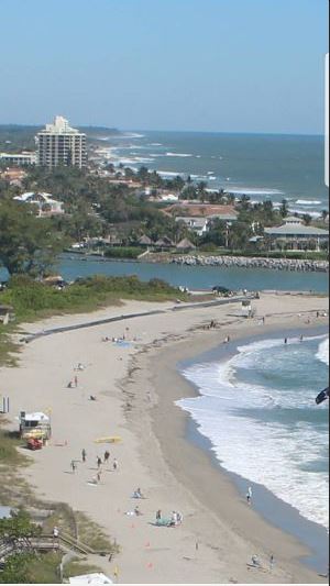
Jupiter Inlet Beach.
Photo by Joe D.

Yesterday I checked out a few South Hutchinson Island beaches and posted photos of those beaches.  I mentioned that I didn't know what was going on with the Vero/Sebastian beaches.  Steve M. sent me photos from that area, and Joe D. sent me photos of Jupiter Beach. Those reports together with mine will give you a good idea of what the beaches around the Treasure Coast are doing.
First, here is what Joe had to say.

I haven't been to the inlet beach for a few months, but went yesterday morning at low tide after looking at the beach cam online! There was a huge cliff at the lifeguard stands, and the rocks were exposed near the jetty! I haven't seen this for s good while, since they usually add sand when it erodes this far back! In fact, they are adding sand in front of the condo's to the south as we speak! I hope they leave the inlet beach alone for awhile longer! 

There were 4 other detectorists working the beach near me, so i left that area for last! When i did work my way over there, i found several coins and a 14ct. Gold ring that they had missed! The Equinox did me well! There was also very little trash, since the renurishment sand was gone, and we were into some older layers finally!   
    
           
Jupiter Inlet Beach.
Photo by Joe D.


Renourishment at Jupiter Beach.
Photo by Joe D.

Finds From Jupiter Beach Including Gold Ring
by Joe D.

Thanks Joe, and congratulations on the gold.  Also, some super hero figures can bring surprising prices.  I've found a few that I've sold.

Yesterday I showed a few of the South Hutchinson Island beaches and mentioned that I didn't know what was going on in the Vero/Sebastian area.  Steve M. then sent in the following photos from that area.

Here is what Steve said.
My wife and went to the beach today to check for erosion. First we went to Tracking Beach as last time we went to go there it was closed and a sign said dune renourishment going on. We immediately went to Jaycee park, to see, but it looked like trucked in sand piled up. Today we found that they made the dune go seaward about 40’ and planted sea oats on it. So first stop, top 2 pics, are South and North of Turtle trail. Beach had a lot of sand up high. But eroded at beach. Next 2 down were Golden Sands. Same conditions. Next 2 down are Treasure Shores, same. Last are Sebastian inlet state park. Same condition. 

And here are those photos.


Turtle Trail Sunday.
Photo by Steven M.


Turtle Trail Sunday.
Photo by Steve M.
Golden Sands Sunday.
Photo by Steve M.


Treasure Shores Sunday.
Photo by Steve M.

Treasure Shores Sunday.
Photo by Steve M.


Sebastian Inlet State Park Sunday.
Photo by Steve M.


Sebastian Inlet State Park Sunday.
Photo by Steve M.

Thanks for all the photos Joe and Steve.  Taking those photos with the ones I showed yesterday gives a pretty good sample of the area beaches.  As you can see, as is often the case, some areas are eroded while others are not.  You might have to visit more than one or two to find the one you will want to spend your time on.

---

I'm expecting a couple days of reduced surf before another increase.

Happy hunting,
TreasureGuide@comcast.net

Saturday, March 23, 2019

3/23/19 Report - Detectorists Still Hitting T.C. Frank Fish Mystery. Bigger Yet Surf Coming? Kellyco Closeout Sale Link.


Written by the TreasureGuide for the exclusive use of treasurebeachesreport.blogspot.com.

Detectorist Favored by The TreasureGuide Cam at Frederick Douglass Beach Near Low Tide Friday.

I got to take a look at a couple beaches Friday afternoon.  There were five or six detectorists at Frederick Douglass Beach.  At least two or three of them were novice snow birds.

The beach there, and the other beaches nearby, had deteriorated since earlier this week.

Despite all the detectorists, I observed no digging.


John Brooks Beach Friday Afternoon.


View From John Brooks Beach Near Low Tide Friday Afternoon.

Fort Pierce South Jetty Beach Friday Afternoon.

Jupiter Inlet Beach
Photo submitted by Joe D.
Joe sent me this photo and pointed out the pipes.  Looks like they are getting ready to dump more sand on the beach there again.

Thanks Joe.

There are a lot of beaches that are a lot bigger than they were back when I was hunting them many years ago.  Jupiter beach was a lot of fun back then before they kept dumping sand on it.

I was looking at the beach up by the condos north of John Brooks today.  It is at least a hundred yards farther out to the east than it was at one time.  There is just too much sand south of the Fort Pierce inlet.  It seems like they are always renourishing the beach there, then the sand works its way south.

Oh, I just remembered I was going to mention that at Seagrape a couple days ago, I did see an older layer of sand down a few inches when I dug a hole.  The older sand was about a half foot deep.  I forgot to mention that then.

I got a couple older items out of the older sand.  One of those is shown below.

Encrusted Object Yet To Be Liberated.
I've got some very similar ones in years past.  A large bullet was in one, but I don't think that is what this one contains.  Maybe a broken piece of spike.

---

Dan B. sent in a link to a story on Frank Fish after I mentioned the legendary mid-century treasure hunter a couple days ago.  Here is an excerpt from that article.

Frank Fish was a highly successful at finding treasure and authored a cute little yellow guidebook called “Buried Treasures and Lost Mines.” His friends wrote numerous articles about him and catapulted his book of doodles and maps to temporary fame. It stands to reason his thrust into the spotlight generated some envious folks and enemies, especially when Fish claimed to have one of two copies of the legendary Peralta Map...

How Frank was killed is a mystery.  It is the kind of story that would make a great movie. 

Here is the link Dan sent if you want to read more about the treasure hunter Frank Fish.

https://www.ghoulifornia.com/home/2017/7/27/the-curious-death-of-frank-fish

---

The surf has decreased.  We'll have big tides, but the surf will be smaller for a few days.  MagicSeaWeed is predicting a six to nine foot surf after that though.

Source: MagicSeaWeed.com
---

Just added:  Warren D. sent me the link to the Kellyco closeout sale on Craigs List.

Includes antiques, collectibles, books, bottles and much more.

https://orlando.craigslist.org/atq/d/casselberry-closed-our-doors-final-days/6829540152.html

Thanks Warren!


I was just received an email from Pavo saying that the closeout sale was in February and ended on March 2.  

That is why I post my sources when I get something second hand (including the media) as well as to give credit where it is due.  I don't think I really have to tell you this, but you should always verify what you read when it might have significant personal consequences.  

I do see that the notice was posted 24 days ago.  

---

Happy hunting,
TreasureGuide@comcast.net


Saturday, October 27, 2018

10/27/18 Report - On Moving Beaches: More Illustrations. Yosemite Tragedy.


Written by the TreasureGuide for the exclusive use of treasurebeachesreport.blogspot.com.

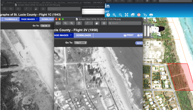
Old and New Photos of The North Fort Pierce Causeway Area.
Submitted by Dave J.
People often talk about how items sink and get moved on a beach.  Movement is a relative thing.

Beaches are dynamic.  Beach sand moves a lotHow the sand moves is often more important than how other items move.  That is often missed.

People often think that when an item or wreck suddenly shows up on a beach that it was washed up and when an item disappears, it sank.  Fact is that just as often the item moved little or not at all, but the sand moved.

Yesterday I was talking about how the sand moves and showed the Fort Pierce inlet area as one example.  Dave J. got what I was saying and did some research on his own.  He sent the above pictures of the area just north of the inlet for comparison.

Dave said, I was just looking at the FP inlet and used some old 1948, 1958 pictures of the corner at north causeway and A1A. Attached is old vs new and looks like an entirely new parcel of land was created (red outline). 

Thanks Dave! That is a great illustration.  

As I said yesterday, the area to the north of the inlet is an area of accretion, while the beach to the south of the inlet tends to erode.  That means that items to the north of the inlet will tend to get covered, while items to the south will get exposed when the sand erodes.

New discoveries are often made south of inlets where the natural flow of sand is interrupted, while older items to the north get covered.  That is on the west coast where the prevailing long shore currents are north to south.

If you want to buy beach front property, you might want to think about an area to the north where the beach will increase, instead of in an area where the beach will be disappearing.

Here is another look at the photo I posted yesterday.

Fort Pierce Inlet.
Compare that with the picture of the Jupiter Inlet (below).

Jupiter Inlet.
Notice the similarity.  Notice how much more narrow the beach is towards the top of the photo.  That is not all perspective.

Once again, the beach to the south of the inlet would be even farther back if it wasn't for all of the beach renourishment projects.

If the Jupiter wreck scattered to the north, it could now be under the accreted sand.

---


This photo of a couple on a high ledge at Yosemite is real.  It looks like fantasy art, but it is not.  Yosemite has the most dramatic scenery of anywhere that I have been, and I'd recommend it to everyone, at least once.

Here is a link to a story about that.   Unfortunately a couple taking a selfie fell off.

https://sanfrancisco.cbslocal.com/2018/10/25/couple-fatal-fall-yosemite-parks-taft-point/

Many years ago I hiked up a trail that got VERY narrow and looked straight down hundreds of feet.  It was too much for me, and I turned around and went back down.  Once I got to the trail head, I looked back and saw a sign at the entrance that said, Trail Closed - Falling Rocks.  Didn't matter to me, because it was way too high and the path on the ledge way to narrow even if it was stable as the Rock of Gibraltar.

---

The tides on the Treasure Coast are nice and high.  There is a beautiful full moon.

There won't be any big surf for a while.

Happy hunting,
TreasureGuide@comcast.net

Wednesday, January 25, 2017

1/26/17 Report - Jupiter Inlet Beach and A Recent Hunt. A Few Common Mistakes. What You Don't Dig Can Hurt You.


Written by the TreasureGuide for the exclusive use of treasurebeachesreport.blogspot.com.

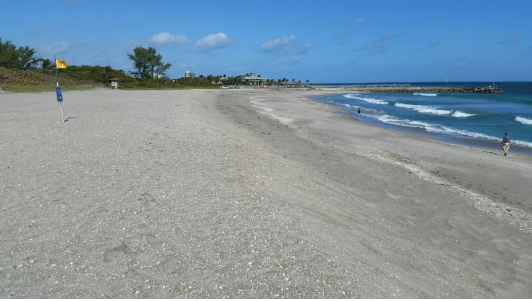
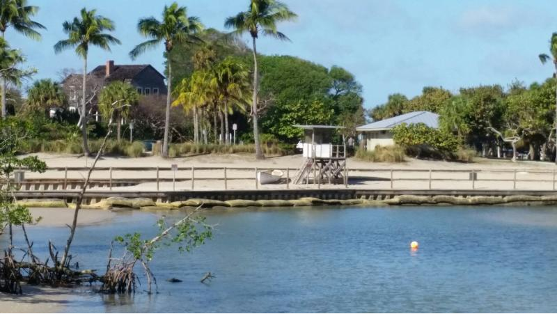
Beach at Jupiter Inlet
Photos by Joe D.

Joe D. sent me the following report and the pictures of Jupiter that are shown above and below.

I hit Jupiter inlet area today just before low tide as front came through! South of inlet much the same as your report today, and a previous report! Cliff was eroded by wind and people only, no water erosion to improve conditions! But for shallow water hunting, There was a nice trough and flat water! 

 Hunted beach area for about an hour and was getting sandblasted from West wind! With little luck due to new sand, opted to try a few other areas nearby that I have been wanting to try out! But without the wind, would be unbearable due to no-seeum's!

 Almost all my finds came from a tidal mangrove area that is very trashy; unlike beach, which is hunted regularly! I had to work for my finds as you can see! (Pic) Interestingly, nearly all the coins i found were from the 70's and looked like they had been there awhile! Also fits with the age progression of the pop tabs I dug! ( as you have said, trash can teach!) One tab was interesting because it had a root growing through it when dug!

 Also threw in a few other pics of the lighthouse, and Dubois house! Anyone looking at historical pics of the Dubois house would notice that the waterway ran nearly up to the house! Which not only sits on a large shell mound, but is also high up a bank near former location of inlet, which is to the south of it's current location! All the land and park in front of it was added when they rerouted the inlet! (Note: No detecting in Dubois Park due to "historical" nature; but not posted!)

Thanks much for the photos and report Joe!

Root Growing Through Pull Tab.
Photo by Joe D.


Finds From Recent Jupiter Hunt.
Photo by Joe D.

Dubois House
Photo by Joe D.

Jupiter Inlet Shipwreck Historic Marker.
Photo by Joe D.
Thanks again Joe!
---

On January 16 I did a post on memorable mistakes that I've made.  It was a popular post.  The mistakes that I mentioned fall into a few basic categories:  (1) not paying enough attention to a dug item in the field to get the significance of the item,  (2) not keeping an item when you don't know for sure what it is, (3) not digging carefully enough, (4) not being careful enough when you clean an item, and (5) not storing an item properly.

There  is at least one other category that probably should be included:  not digging a good item.  Of course, you don't know it at the time, but when you don't dig items you don't know what you left.  I'll bet a lot of what would have been your very best finds, were left in the ground.

The thing about the very best finds is that they are rare.  You don't expect to dig a Rolex watch or a 40 pound silver bar everyday.  It doesn't happen that often, and when you hear the signal, you probably won't know what it is until you dig it.  No detector that I know of has a reading "Rolex Watch" or "40 Pound Silver Bar."  Many detectorists miss great items like that simply because they do not dig items when they don't know what they are.

An eight reale can sound a bit like a tin can, so if you are accustomed to not digging things that sound too big to be a coin, there is a chance that you left something very good like that in the ground.  Things like that you won't regret not digging because you'll never know for sure what it was.

There might be some class of desirable items that you are not digging.  Early in my detecting, I wasn't getting small gold rings.  I've told this before, but I thought that women didn't lose as many rings as men.  Later I found out the that the reason that I was getting more men's rings than women's rings was because I was using discrimination and missed a lot of the more valuable small and valuable women's rings.  I was glad that it didn't take me too long to learn that.

It also took me a long time to find any shipwreck spikes.  I am certain that I would have found some sooner if I had not been skipping larger iron targets.  In those days I was targeting modern gold jewelry. The fact is that how you hunt will determine to some extent what you find, but it will also determine what you do not find.  Review your finds to see if there might be a reason you are not finding some of the types of thing you would really like to find.

---

Think about what I posted from Joe D.  Is there a spot near a beach that you regularly hunt that might contain more targets than the beach that you hunt on a regular basis?  That can be worth thinking about. Sometimes there are good areas that nobody hunts that are very close to heavily over-hunted areas.

---

The next few days we'll have more smooth west winds and smooth surf.  No change in beach conditions.

Happy hunting,
TreasureGuide@comcast.net


Saturday, April 23, 2016

4/23/16 Report - Treasures In Renourishment Sand. Jupiter Inlet Beach. Ring: How Old Is It? Dare.


Written by the TreasureGuide for the exclusive use of treasurebeachesreport.blogspot.com.

Big Cut South of Jupiter Inlet
Photo by John B.
T,his cut is in renourishment sand, but that doesn't necessarily mean there is nothing good in it.  Although it doesn't happen often, very good things can be found in renourishment sand.  WW II items were found in renourishment sand at Fort Pierce.  Silver U. S. coins were found in the renourishment sand at Ambersands not too long ago. Even Spanish galleon materials have been found in renourishment sand.  It is good to know where renoruishment sand is collected, and it can be worth checking renourishment sand.  There are times when there will be tons of old aluminum cans and other junk, but sometimes there will be things that are millions of years old.

Same Cut Showing Layers of Shells Etc.
Photo by John B.
Check the face of any cut to determine what might be in the sand.  In the photo above, you can clearly see some layers.

Thanks for the great pictures John!


Very Nice Shark Tooth
Find and photo by John B.
Here is what John said.  There was a pretty good cut along the beach just south of Jupiter inlet but it was all renourishment sand.  Lots of small iron junk targets, shells and shark teeth.    

That is a nice tooth.  Notice the serrations.

---

Yesterday I posted some items from the beach at Corrigan's.  That prompted Paul B. to send me the following email.

Hello, found this ring on one of the Ft. pierce beaches several years ago. I thought it was a more modern piece, but after looking at the pictures you posted today of the gold rings, now I'm not sure. It's silver with no markings and the stone looks as if it could be jade. What do you think? I'm attaching pictures.
Thanks,
Paul B.

Find and photo by Paul B.

What do you all think?  I have a hard time telling from photos.  Most modern rings would have a marking, especially if it is gold or silver.   

Paul provided a number of excellent photos.  Still there are some things I can't tell without actually handling.  It can be difficult enough even when having the item in your hand.

I'd appreciate any comments though.

---

The crew of the Dare is using Dolores (HAUV) to explore the deep mud at the south of the Atocha trail.

---

Happy hunting,
TreasureGuide@comcast.net