Showing posts with label hurricanes. Show all posts

Wednesday, September 18, 2019

9/18/19 Report - Hurricanes Humberto and Jerry. Erosion in Jupiter Area. Silver Find From Vero Area. And More.


Written by the TreasureGuide for the exclusive use of treasurebeachesreport.blogspot.com.

Source: nhc.noaa.gov
Look at that!  Humberto hasn't completely left yet, and it looks like there will be a Hurricane Jerry headed in this general direction.


Source: nhc.noaa.gov

That could send us even more surf.

I haven't been out and around much yet, but hope to get out this afternoon and should be able to give you a beach conditions rating later today.


With Jerry following Humberto, we might get continued higher surf.


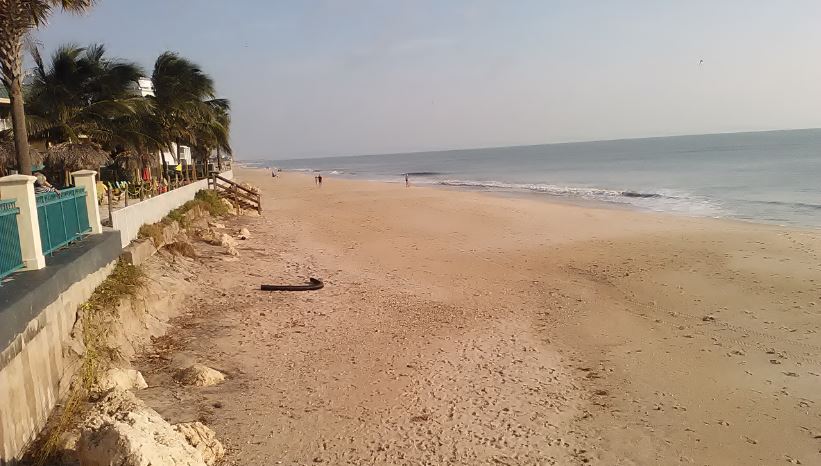
Eroded Beach in Jupiter Area
Photo by Jerry P.
Jerry said he used Ventusky.com, which you'll find on my first blog page, to find an area where conditions might be good, and he found this nicely eroded area.\

Thanks for sharing Jerry.  Very good use of Ventusky to find a good detecting site!

---

Here is one nice find from the Vero area.

John E. said, I’m stumped on this one.... exact size of a dime , registers a 21 on equinox 800..... found in about 14 in deep wet sand on treasure beach in vero, can anyone identify?

John E


Find and photo by John E.
He said the words above the star are FRIAY LIBER.

Other Side of Same Coin
Photo by John E.
I'm pretty sure it is a centavo from Cuba and can almost make out a date below the star.  I'd also guess it is silver.  Looks like it to me.   A little research should provide the denomination.

Thanks John.  Nice find!

---

Here is an interesting email message I received from Southern Digger concerning a link I posted yesterday.


Hello TG 

Been awhile corresponding but still following up. Archeological site locations on Hutchinson Island and elsewhere along the beaches is no big secret. I recall an old beach mound near the now closed Indian River inlet. I believe some of it has since been washed away. Years ago, a friend and I hiked to a hammock Island near Round Island Park, long before this hammock was developed. We used machetes to cut in to the center, finding old metal rods with eyelet ends which appeared to be from old sailing ship mast supports. Why they ended up way back of the beach we never could determine, unless a camp was made thereon by some 1800's shipwreck survivors.  Also, prehistoric evidence was everywhere. Thought it was interesting and a possible site to return to, we never did, that is until major changes took place thereon. Since then, the under-story was cleared and Univ. of Maryland (I believe) did an archeo survey on the hammock. I was invited to return after that, and did so--still seeing prehistoric evidence in abundance scattered everywhere. This was my last visit when construction began thereon for some type of structure. Another archeo site way to the south exists behind the beach at the water plant. I was asked to direct the Archeo. survey via an Env. firm I worked for at the time--but turned it down and recommend someone else because the end of the survey results and how the report should read were told to me before the project even started. In effect, regardless or not if there are burials. the site would be dozed and built upon. I turned it down even though I would be hired to direct the project because, at the time, I was being trusted on several other volunteer archeo. projects to the south which did not involve the Env. firm; and, I did not want a reputation of being a sellout for the $$$$ and destroy possible burials. That is a strict policy I adhere to to this day because I have seen way to much archaeological and historical sites destroyed and developed in which I had no control over or the power to prevent it from occurring. That is the nature of land development and the destruction of Old Florida. 

Thanks Ken.

--

I hope to get out this afternoon. I expect to be able to post a beach conditions rating after that - maybe later today.

At this point I am expecting a few reales to be found this week.

---

PM Update.

I looked at a few beaches in the Vero/Sebastian area and saw nothing encouraging at all.   I'm expecting fewer finds now than what I just said above.

Happy hunting,
TreasureGuide@comcast.net

Friday, September 6, 2019

9/6/19 Report - Indian River County Says No To Tourism and Keeps Beaches Closed. Bad Hurricanes Not New. A Few Finds.


Written by the TreasureGuide for the exclusive use of treasurebeachesreport.blogspot.com.

Vero Beach This Morning.


Indian River County Turns Away Tourists and Beach-Goers.  

If you came to Florida to visit the beaches, stay away from Indian River County.  The county beaches were closed.

Two were being guarded by the Sheriff's Office.  Marked cars were parked in front of the closed gates at both Turtle and Seagrape Trails the past few days.  I don't know why the extra expense to guard those two particular beaches was necessary.

The gates were closed this morning at Turtle Trail, Seagrape Trail, Wabasso, Treasure Shores, Golden Sands, Amber Sands, and probably others that I did not see.

At least a dozen cars were parked along the road by Treasure Shores this morning.  I noticed one older couple walking into the park.

Several detectorists were also parked along the road about half way between Wabasso and Seagrape Trail.  There is a path there that has been used by detectorists for decades.

You can get onto the beach at Vero (See photo above.).  One detectorist was busy there this morning. There was apparently no danger there.

The gates at Rio Mar were also open, but there were no parking spots open. 

Round Island park was also closed.

---

Pablo M. Sent This Photo of a 9/4 Find From Turtle Trail.
Pablo M. sent this photo of a find from Turtle Trail.  I can't quite make it out.

---

Dave sent this message and a photo of his recent finds from Walton Rocks.

Hello. Yesterday I started at south end Walton Rocks, up high in front of condos and found some hard pack cutting into dunes. Tide hitting as I left.  A lot of clad, lures,sinkers,1 piece silver ,old wood iron banding still attached. As always you are spot on when it comes to your posts., I appreciate all the hard work it takes. Look fwd to your blogs end of every day.   Dave.

Walton Rocks Finds.
Finds and photo by Dave.
---

Dorian may not be as unique as some suggest.

One of the most fatal hurricanes in history hit West Palm Beach in 1928 as a category four, killing at least 3500 people when Lake Okeechobee overflowed.

While the 1928 storm was the most deadly, the most powerful storm hit on Labor Day of 1935

The other irony: while the Okeechobee storm was one of if not the deadliest in state history, the most powerful meteorologically was a storm that came as the strongest one in recorded U.S.  history on September 2, 1935 — Labor Day. Originally, it was projected to hit on the same date (until it slowed, coming in now, they say, early Wednesday, if at all; we’ll see soon…). No other storm had lower barometric pressure (892) nor greater wind speed (at one point sustained winds of 185, at least for a full minute). But now Doria is about that same strength. The Labor Day Hurricane’s storm surge was eighteen to twenty feet, badly damaging the Florida Keys and actually obliterating one of them, Islamorada. We once interviewed a survivor who lost virtually everyone in his large family and had to swim all night in the dark as a child.

“It’s devastating,” said Joy Jibrilu, director general of the Bahamas’ Ministry of Tourism and Aviation. “There has been huge damage to property and infrastructure. Luckily, no loss of life reported.”

With its maximum sustained winds of 185 mph (295 kph) and gusts up to 220 mph, Dorian tied the record for the most powerful Atlantic hurricane ever to come ashore, equaling the Labor Day hurricane of 1935, before the storms were named.
Source of quote: https://spiritdailyblog.com/commentary/remembering-two-storms

---

Three deaths in Florida were attributed to injuries sustained during hurricane preparation.  I can only imagine how many other injuries there were.

I have some good emails on that subject that I'll probably post in the future.

I expect to have some more find photos to share before long.

That is all for now.

Happy hunting,
TreasureGuide@comcast.net

Monday, September 10, 2018

9/10/18 Report - Three Hurricanes Now In The Atlantic. Little to No T. C. Erosion. More Silver Coins Found by Using a Magnet.


Written by the TreasureGuide for the exclusive use of treasurebeachesreport.blogspot.com.

John Brooks Beach This Morning Near High Tide.
The surf was nearly flat this morning at John Brooks.  The high tide had been far back on the beach, but not to the dunes.  As you can see in the photo, there were some scattered shells.

Source: nhc.noaa.gov

Florence, Isaac and Helene have all become hurricanes.  That is quite a parade.

Florence still looks to be headed towards North or South Carolina,, Isaac into the Caribbean, and Helene to the North Atlantic.

Helene will probably be no threat to the U. S.

I won't show the predicted tracks of each today.  I'll do that again tomorrow or some time soon.

The Treasure Coast surf for this week still looks promising

Source: MagicSeaWeed.com.

The Treasure Coast surf predictions haven't changed much for several days now.  It still looks like Wednesday we will get some good surf.  The tides are now pretty big also.

---

a50% Silver Canadian Quarter.
Just before the Atlantic became so active I asked if you knew how many silver coins you've found.  Today I am showing three silver coins that I had a long time before recently discovering that they were silver.  They were sitting in a pile of miscellaneous foreign coins that I accumulated over the years and hadn't paid much attention to.

Above is a 50% Canadian silver quarter, and below are two 50% silver dimes that I found.  

I would not have guessed that the 1968 quarter would be silver.  I discovered that it was silver when I used a magnet to screen a bunch of Canadian coins that I dug up over the years.  Most of the Canadian quarters, and dimes, stuck to the magnet.  The silver ones did not.

In 1968 the first quarters were made of silver, but those made later in the year were made of nickel.  The ,magnet test showed the one above to be silver.

1962 and 1963 50% Silver Canadian Dimes.


I had previously discovered some silver Canadian coins but hadn't looked through the entire pile.  Those that I had discovered before included some that were much older than these.

I've been very impressed by the usefulness of a magnet for testing coins.

I read one web site that said that UK coins are magnetic and U.S. coins are not.  There are exceptions to that.  There are the steel war cents that the US produced in 1943, for example.  And there are many older U.K. coins that are not magnetic, including silver and gold coins.  There are always exceptions, it seems.

There are also transition coins. like the Canadian quarter shown above, that were made of a magnetic material for part of a year and a non-magnetic metal during the other part of the year.  And there also error coins that were created on the wrong type of planchet.  Those can be very valuable.

In 1943 the U.S. mint made steel pennies.  In 1944 they used copper again, but a few 1944 pennies were mistakenly made on steel planchets.  If you find a 1944 steel penny, it could be very valuable.

I've been talking about using a magnet to test coins, but there is a danger with that.  The magnet can scratch your coins, which can diminish the coin's value.  Don't use a magnet on coins that are in excellent condition or potentially very rare or valuable without taking precautions.

I've found two ways to diminish the danger of a magnet scratching the coins.  One is to put a cloth over the magnet.  That will help, but there are probably better methods.

Another method is to stack the coins and hold the stack between your thumb and forefinger and place the stack of coins on the magnet so only the edge of each coin contacts the magnet.  The magnet will still separate the magnetic ones from the non-magnetic coins, but only the edge of the coin is at risk of touching the magnet.

---

I added the great token database to my treasure reference link list.

---

Happy hunting,
TreasureGuide@comcast.net
Sunday, September 9, 2018

9/9/18 Report - Safe Uncovered. Now Three Named Storms That Could Become Hurricanes Moving East.


Written by the TreasureGuide for the exclusive use of treasurebeachesreport.blogspot.com.

Source: See CBC link below.


An old iron safe discovered by construction workers digging up part of downtown Dawson City, Yukon, is generating a lot of curiosity.

"Everybody wants to know what's inside, but we checked with YG [Yukon Government] heritage resources and the local museum and neither of those people seem to be interested in it," said Mark Dauphinee, superintendent of public works in Dawson City....

Here is the link for the rest of the story.

https://www.cbc.ca/news/canada/north/yukon-dawson-city-safe-discovered-1.4777964

---

For us the Treasure Coast the big story is that we have three named storms now.  You can see that it looks like a parade of storms coming off of Africa now.

Three Named Storms.
Source: nhc.noaa.gov.
Besides Florence, there is now Isaac and Helene.  I said a couple days ago that North Carolina could get hit by Florence.  Now that is what the TV news is saying.  Worse yet, if the Ventusky.com projections are correct, Florence will slow down and hang near the Coast of North and South Carolina for quite a while.  Of course there could be changes to any of that.

Florence.
Source: nhc.noaa.gov
According to the above cone, there is a good chance North Carolina will get the strong north side of the storm.

But the one I'm thinking could hit near us is Isaac.  We got the I storm last year - Irma.  That one caused a lot of problems.

Isaac.
Source: nhc.noaa.gov
It is too early to say with any kind of certainty where Isaac might go, but the NHC has it going across the windward islands as a hurricane.  The storms normally turn north at some point.  If it turns early, it could hit the East Coast of the U.S., or if it turns later, it could go into the Gulf.  Still too early to tell.

Helene.
Source: nhc.noaa.gov
It looks like Helene will go out into the Atlantic and not be much problem to the U. S.

So what does all that mean to us this week?

Surf Predictions.
Source: MagicSeaWeed.com.
It still looks like we'll get a day or two of big surf.  Those other days of three foot and more surf could help too, depending upon how they hit.

Bottom line is that you need to be ready for the possibility of improved beach detecting conditions some time in the next week or two.  Get your batteries charged and your equipment in good order.

Happy hunting,
TreasureGuide@comcast.net

Sunday, May 13, 2018

5/13/18 Report - Happy Mother's Day. Do It Today. Hurricanes Intensifying Faster.


Written by the TreasureGuide for the exclusive use of treasurebeachesreport.blogspot.com.


I mostly just wanted to say happy Mother's Day, especially to all of the mothers.  I hear from more women detectorists than you might expect.

Just the other day my neighbor told me some the things he said he'd do if he was retired.   It seems like everybody has things they plan to do when they retire.  You always think you'll have more time to do the things when you retire, but it doesn't necessarily work out like that.  Besides, a lot of things can change in a few years.  I had no idea how things would change in my life.  And I had no way of guessing just how things would change.

I actually feel like I have less now to do the things I want to do now that I am retired.  I found a way to do things when I was working, and no if you are working or not, you have to make time for what you really want to do.

My advice would be don't wait.  A lot of things can happen.  Believe it or not, when you get older, you might not be have the same energy and health you did when you were younger.   Its hard to be the same at seventy or eighty as you were at thirty or something.   It's not just a number.

You might not be as healthy or fit or able.  Unexpected things happen to a lot of people as they get older, and not all of them are good.

Also think about your loved ones.  They might have additional problems too.  Taking care of an elderly parent can be a big job.  You can end up with new responsibilities that you never thought you'd have.

You might change in other ways too.  Maybe your desires and priorities will change, and those things that you once loved to do might someday seem trivial or meaningless - especially when you no longer have the people around that you'd like to share it with.

The only thing I'm saying is that if there are good things you really want to do, don't put them off for some distant time.  You never know what the future will bring.   That is how it looks to me.

Today is the day - in more ways than one.  Make it as special and memorable as you can.

---

Hurricanes are now undergoing rapid intensification faster than they did 30 years ago in parts of the Atlantic Basin.

Rapid intensification is defined as an increase in wind speed of at least 35 mph in 24 hours or less.

The main instigator for this change is an atmospheric circulation known as the Atlantic Multidecadal Oscillation (AMO)...
Here is the link for more about that.

https://weather.com/storms/hurricane/news/2018-05-09-powerful-hurricanes-strengthen-faster-now-than-30-years-ago

---

Have a wonderful Mother's Day.
TreasureGuide@comcast.net

Saturday, September 30, 2017

9/30/17 Report - Its Not Over Yet. More Surf To Come. Mayan Monument. Ballast Rock? Worked Bone. Blog Poll.


Written by the TreasureGuide for the exclusive use of treasurebeachesreport.blogspot.com.

Source: nhc.noaa.gov
If you are not yet tired of hurricanes and stormy weather, there is still a lot out there to watch.  Hurricanes Maria and Lee are still on the map, but more importantly there are two areas closer to Florida to watch.  One is right over Central Florida and the other, down towards Puerto Rico.

Source: MagicSeaWeed.com
As you can see, MagicSeaWeed is predicting a 6 - 9 foot surf for Wednesday and Thursday.  That is a pretty good surf.  I don't care for the predicted wind and swell directions, but at this point all of that  is just a prediction and could change.  That surf is enough to keep my attention.

The tides are very moderate right now too.

---

First M LB* Sports Cards
Discovered in 2015, the two ballplayer panels are the first of their kind to be found in Belize, the researchers said. Both have carvings depicting ballplayers and hieroglyphic captions, and they are thought to date to between about A.D. 600 and A.D. 800, Andres said...

The ballplayer was depicted as standing and holding one hand over his heart.

Researchers said the panels had a sweet smell and there was a pink residue on the panels.

They evidently weren't old enough to know that in the fifties and sixties, baseball cards came in a pack with a big wad of bubblegum.

The first part of this is true - down through the blue text.   The part after that was just me entertaining myself and perhaps a few other oldsters.  If you are old enough to have collected the old bubblegum cards, you would know what I was talking about - otherwise probably not.

Anyhow, if you want to read about the archaeological find, here is the link.

https://www.livescience.com/60552-maya-ballplayer-stone-panels-discovered.html


* MLB indicates Mayan League Ball

---

Possible Ballast Rock.
I posted this stone the other day and labeled it as a ballast rock.  I put a question mark after it because I'm not absolutely sure that is what it is.

First, it is that it is not a type of rock that is natural to Florida.  Here is a link that will take you to a web site that shows the types of rock that are found in Florida.

http://www.dep.state.fl.us/geology/geologictopics/rocks/florida_rocks.htm

Second, it would make excellent ballast, being dense and rounded.  Although they would use all kinds of things for ballast, including metal or whatever rocks could be found including more angular rocks, Robert Marx wrote that rounded rocks were preferred.  Rounded rocks were also readily available in rivers near many European ports.

I've seen ballast rocks just like this, and this one did come from a beach very close to a known wreck ballast pile.

It is always possible that it a landscaping or other rock imported to Florida for some other purpose, but in my opinion, weighing all the pros and cons, there is a better chance that it is a ballast rock than an imported ornamental or construction rock that somehow found its way to a beach very near to a ballast pile.

Here is an interesting and relevant article on The Provenance of the Stone Ballast on the Molasses Reef Wreck by William Lamb, 1988.

http://nautarch.tamu.edu/pdf-files/Lamb-MA1988.pdf

---

Piece of Fossilized Bone.
I took a closer look at this piece after it sat around for a few days.  I almost always do that with finds.  I noticed what appears to me to be a rounded cut at the top.  I don't know much about either fossils or Native American artifacts and would like any informed opinions.  I do know that they often made an attempt to get the marrow out of bones, and this bone is hollow, but I don't know if it is natural or worked.

----

I woke up last night after what I thought was the funniest dream.  I was in school.  I just found a desk and sat down.  The teacher, who looked much like my little old lady first grade teacher, came over to my desk and told me to go get a cantaloupe.  I looked at her quizzically, and she said, "Go buy a cantaloupe and bring it back here."   That struck me so funny that I woke up and had a big suppressed belly laugh trying not to wake my wife.  It just seemed so odd and funny to me.  I don't know if you'll find it humorous at all.  I had another very funny dream after that, but I doubt you really want to hear about it.  I guess I'm just in a funny mood.  I hope you can forgive me.  Very entertaining night though.

It must have been those MLB (Mayan League Ball) cards that got me started.

---

All responses to the blog poll are much appreciated.  Thanks.

If you've been watching that, you've seen that some good things were found since this turbulent month began.

---

I wanted to talk more about the changing shoreline, but didn't get it together yet.  Might take some more days.

Happy hunting,
TreasureGuide@comcast.net

Wednesday, September 20, 2017

9/20/17 Report - Storms, Hurricanes, Predictions and What To Watch For. Thanksgiving Storm of 1984. Walking Sea Shells. Big Surf Predicted.


Written by the TreasureGuide for the exclusive use of treasurebeachesreport.blogspot.com.

If you only read to see when something has been found, you will sometimes be a little late.  But if you read this blog on a daily basis, you should seldom be caught off-guard.  I spend a lot of time watching developments and predictions and tell you when things might happen before they actually do.  Of course the predicting game isn't perfect.  The meteoroligists are often wrong.   Just look at how Irma developed.  They didn't know where it was going to go until the last few days when the predictions finally firmed up.  It isn't easy.  And it is often wrong.  Yet you should be prepared and ready as well as possible if you keep watching.

I am watching Maria very closely.  She isn't expected to make landfall in Florida, but that is not the important thing when it comes to metal detecting.  Some of the most legendary treasure detecting occurred when there was no hurricane at all.  It only takes a storm that sits off the coast and churns waves for days.

I've gone over this before, but it is a good time to go over it again.  You might be wondering what it is going to take.  We just had a hurricane go right up through the state, and still it didn't do a whole lot for the Treasure Coast. The best illustration I know of is the Thanksgiving Storm of 1984, which is legendary in Treasure Coast treasure lore.

The following data presented in a NOAA publication with the title The Florida East Coast Thanksgiving Holiday Storm of 1984 by Raymond Biedinger, Clifford Brock, Federico Gonzales, and Burt Sylvern.

I'll present some of the NOAA report below and point out by bolding and underlining some of the statements that I think are most noteworthy. Here goes.

Another factor was that these strong onshore winds continued for many days. Winds of near gale force (about 40 miles an hour) began blowing along the north Florida coast the evening of the 20th. They did not subside until late on the 24th. Therefore, much of Florida experienced strong onshore winds for about 4 whole days. These winds were frequently between 30 and 40 miles an hour. The direction of the winds was from the north northeast which is probably the best angle of incidence for beach erosion along the coast from Fernandina Beach to Palm Beach. The coastline south of Palm Beach was spared from most of the adverse effects of the storm because the wind was actually blowing offshore throughout much of the storm. However, this northwest wind caused significant damage to the coastlines of the western Bahama Islands Friday and Saturday. This was all due to the position of the storm center remaining over Grand Bahama Island from early Thursday morning through early Saturday...


As noted earlier, the time of the month that the storm occurred was coincident with the highest astronomical tides of the month and nearly the highest spring tide of the year. Tide tables indicated that the highest predicted tides for the month of November fell on the mornings of the 22nd and the 23rd, exactly during the time of the highest storm tide. Reports from the storm survey teams of the Florida Department of Natural Resources indicate that the storm tide was over 6 feet above low mean water. Tide gauge readings at Mayport were 7.5 feet above mean low water or 5.2 feet above mean sea level. The one factor of the storm episode which magnified the entire situation was the nearly stationary nature of the storm for 3 days. This lack of movement produced the prolonged onshore winds which resulted in at least 4 days of heavy surf pounding the shore. Portions of the coastline experienced 9 high tides during this period, with each succeeding high tide higher than the previous one, thus making the erosion of sand greater with each tide. These are the reasons for the extensive damage that resulted from this particular storm....


...The meteorological conditions just described produced one of the most damaging storms to affect the eastern coastal sections of Florida during the past several decades. Much of the damage from Fernandina Beach southward to North Miami Beach, nearly 400 miles, was caused by the easterly winds of gale force with gusts as high as 60 miles an hour blowing for nearly four days. This action of the wind over the ocean produced shoreward moving swells of around 20 feet which pounded the Florida east coast and produced the most severe beach erosion in recent years in many areas. An example of the destruction was the reduction of the newly completed l100 foot pier at St. Augustine to 300 feet. Sand dunes were obliterated leaving barrier islands void of any natural protection against the next onslaught of a coastal storm in the future. To add to the destructiveness, the highest monthly astronomical tide period coincided with the highest period of storm tides which occurred on the morning of Thursday and Friday, the 22nd and 23rd. All of this produced tides 4 to 6 feet above mean yea level (MSL} at times of high tide. In some places, this was the highest tide in the last 30 years. Alt Mayport, Florida, just north of Jacksonville, the tide of 5.2 feet above MSL was the third highest tide of record. Much of state road A1A, the famous coastal highway, was closed in Indian River County between Vero Beach and Sebastian Inlet because of high water. In this area several beach front buildings collapsed, and 600 to 1,000 people were ordered to evacuate their homes. In Palm Beach County, five blocks of A1A were seriously damaged by the high tides and heavy surf. Bridges were closed because of flooded approaches which caused some barrier islands including the large Hutchinson Island to become isolated for periods of time around the time of high tide. In the storm's aftermath, severe coastal beach erosion stretched from Jacksonville to Palm Beach. ...

 At the West Palm Beach weather office, a new station rainfall record was set on Thanksgiving Day for the greatest amount in a calendar day, 7.41 inches....

There were high winds that blew for three or four days and we were having high tides at the same time.  That is in strong contrast to Irma.

Here is the link to the entire report. http://www.srh.noaa.gov/images/mlb/pdfs/Nov_1984_storm.pdf
---

Yesterday Joe D.told me, Bonsteel to past Rio Mar, all sanded in still!!

Darrel S. said, 

State Park announced 33 parks are still closed. I assume the ones inland more then the coastline, unless Keys or First Coast.

Most of the beaches near St. Augustine were telling people not to walk on the beaches until further notice. I know that area really got slammed!

I have not heard from any dectorists, so cannot give any info on finds or if they are able to detect.

I would bet inland areas where trees are uprooted would be good searching. Especially, around old towns, water holes, etc.

Bet some good bottles and arrowheads could be found.


Under more normal circumstances I would have talked more about some of the other areas around the state.  One person asked about shipwrecks in the Naples area, for example.  Treasure cons are found over there.  That is about all I had time to tell him at the time.

There are certainly other areas that will be producing treasure - perhaps more than the Treasure Coast right now.  The Treasure Coast is now pretty much sanded in.

Thanks to Joe and Darrel for submitted their observations.  I hadn't been up to Bonsteel and wondered about that.

---

There are now some beautiful shells on some of the beaches, including Frederick Douglas beach. Some are big and colorful. When you pick up one of those shells, please check to see if it is inhabited by a crab or some other creature. Many of the nicest will be inhabited. The inhabitant might be very difficult to see. When you pick up an inhabited shell, the creature will withdraw into the shell as deeply as they can. It might be very difficult to see. If you mistakenly take a pretty shell home believing it to be abandoned when it is not, you'll notice a strong smell when the creature dies.

Hermit Crab In Seashell.
Source: Wikipedia
That subject always reminds me of the time on Key Biscayne when I saw a hermit crab using a broken bottle neck with the bottle cap still in place as a  mobile home.  I always wish I had a photo of that.

---

Below is what I'm watching now.  MagicSeaWeed is predicting up to a 13 foot surf for Sunday.  I wouldn't be surprised if it turns out to be smaller, but that isn't the only factor.  We'll have to watch the wind direction and tides too.

Source: MagicSeaWeed.com
Some detecting opportunities are short-lived - lasting only a matter of hours, while others last days or more.

Happy hunting,
TreasureGuide@comcast.net

Tuesday, January 17, 2017

1/17/17 Report - Florida More Than 50% Chance of Hurricane in 2017. How Metal Detecting Is Something Like Battleship Game.


Written by the TreasureGuide for the exclusive use of treasurebeachesreport.blogspot.com.
Predictions for 2017.
Source: See link below.

According to predictions, the state of Florida has a 51% chance of a hurricane hitting in 2017, and a 21% chance of a major hurricane.

Here is the link.

http://weatherplus.blog.mypalmbeachpost.com/2017/01/15/what-are-the-chances-a-hurricane-will-hit-florida/

---

Some people say there is no way to tell where things are going to be found when salvaging shipwreck treasure.  They talk as if the shipwreck remains are distributed randomly.  That isn't the case.  You might where you will find any each and every item, but it is not random either.  And you might not know how things ended up being where they were found, but there is a reason they ended up where they did.

The people who salvage shipwrecks as a business try to understand things like how a ship came apart, where it hit the reef and which direction the wind was blowing when it wrecked.  They study charts like the one shown below to see where holes have been blown and what was found at each location. They wouldn't study such things if they didn't think it would help.


It reminds me of the game Battleship.  That is a game where one player places his ships on a grid, and the other player selects grid locations attempting to hit the other player's ships.

When you try to hit the other fellow's ships, you might start out with a random selection, but when you finally make a hit, you have some information and your next selection won't be random - at least not if you make use of the information you gained.

In the game, when you get a hit at one location, you know that the rest of the same ship must be at an adjacent grid location. That is because the hit gives you information that tells you that the adjacent locations have a higher probability of being where you will find more of the same ship.

It isn't exactly the same with treasure salvage.  There isn't always an adjacent location that will also contain an item,  You still have a better chance of finding something good when you excavate near a good find than if you picked a random location anywhere in the sea.  It is about probabilities.

There is almost always some type of clustering when it comes to metal detecting.  While an individual item might show up anywhere and have no particular known relation to any other object, generally speaking there will be clustering.

If you look at the chart above showing holes and coded to show what type of object was in each hole, you'll notice that both holes and colors are sometimes clustered.  People use that kind of information to figure out where to dig next.

You don't find ballast rocks randomly distributed over miles of ocean, for example.  There will more than likely be a pile somewhere.  And other heavy items will likely be with the pile, such as cannons or heavy silver bars.  That might be partly because they were stored in the same part of the ship.

There are principles that determine where things will end up.  There are a variety of factors.  That is what makes it complicated.

There is also clustering of items in wet sand areas, whether they are ancient or more modern.  The water will shift and sort things over time.

The longer an item is in a high energy environment, the more it will be sorted.  As a result the pattern will become more defined.  That is how coin lines and coin holes are formed.

There is also clustering of new drops in the dry sand.  Those items have not been affected by Mother Nature, but they are clustered by human nature.   People congregate together and lose items where they congregate.  People participate in different types of activities - volleyball, for example.  More items are lost on volleyball courts than in wide stretches of sand where nothing much takes place.  Furthermore, more items can be found at certain areas on and around volleyball courts.

Since things are not generally randomly distributed, your search should not be random.  The more you understand about how items were lost and the forces that might have acted on them after they were lost, the more you will find, as long as you spend the time.

---

The surf is now down to 2 - 3 feet and will continue to decrease for a few days.

Happy hunting,
TreasureGuide@comcast.net

Sunday, October 16, 2016

10/16/16 Report - New Blog Poll Started.


Written by the TreasureGuide for the exclusive use of treasurebeachesreport.blogspot,com


First here is a little explanation of the new blog poll.

I'd consider Jupiter to Melborne to be the Treasure Coast.  That might be a too broad, but lets go with that for the poll.

As you know, Matthew hit North Florida harder than the Treasure Coast.  I know of cobs being found to our north so I included poll responses for both the Treasure Coast and elsewhere, which would include North Carolina and other areas affected by Matthew,

Since Nicole sent so much water this way, some finds could actually be attributed more to Nicole rather than Matthew.  If you were not affected by either Matthew or Nicole, this poll is not for you.

The poll will give us some idea of how much of what was found after these storms.  I don't think it was a lot, but there were some interesting finds that I've heard about,

I think the poll is otherwise pretty much self explanatory.

Your answers are very much appreciated.  Not only do they help us learn what has been found, but it also helps me to improve my beach detecting conditions ratings,


I might or might not add more to this post or another post later today.

Sunday, August 14, 2016

8/15/16 Report - Flintlock Pistol From Treasure Coast Beach. Thoughts On Religious Relics. World Wide Web 25 Years Old This Month.


Written by the TreasureGuide for the exclusive use of treasurebeachesreport.blogspot.com.

Flintlock Pistol Found After Hurricanes of 2004.
Photo submitted by Darrel Strickland.
Lately I've been showing some noteworthy treasures that were found a few years ago, especially after the hurricanes of 2004, which was some of the best hunting we've had since the legendary Thanksgiving Storm of 1984.  A lot of treasure was found by a lot of people after Francis and Jeanne. You've never heard of most of it, and I'm only showing a few pieces.

The flintlock pistol shown above was found by Tom K., who found the pistol "at Wabasso Beach going north towards Golden Sands in the wet sand near the water's edge."  Thanks for sending the photo and email Darrel.

I don't know if Tom ever got the pistol cleaned up or not, but he wasn't in a hurry to clean it at the time because he thought it might be damaged in the process.

Tom also found some rings that day.

Here is charm or rosary piece found back then too.

Photo submitted by Darrel S.
I've shown some of the famous religious pieces found by the salvage divers, and Laura Strolia has provided authoritative research on some of the most fascinating ones. Click the following link to go back to a post containing some of Laura's research on the Pelican of Piety.

  http://treasurebeachesreport.blogspot.com/search?q=pelican+piety

Before Laura's research was published, the gold Pelican of Piety was often mistakenly referred to as a reliquary.  A reliquary is meant to contain a relic.

I recently found an article about first-class relics being sold on the internet.  A first-class relic is an item or piece of an item directly associated with event's of Christ's life or the physical remains of a saint, for example bone or hair.

One person wrote an article about selling first class relics and wants the practice stopped. The author of that article, Ryan Scheel, had the following to say.

The listing of first class relics “is incredibly insensitive to the Catholic faith in way I doubt would be tolerated for other religions,” Scheel said. 

“But also...common decency should tell eBay that profiting off of the sale of body parts is ghastly and unethical, no matter who the remains belonged to in life.”
That's why Scheel decided to launch a petition calling for eBay to remove the listings of the first class relics. He hopes to obtain signatures from at least 25,000 Catholics in order to alert the site of the illicit sales.”

Here is the link to that article.

http://www.ewtnnews.com/catholic-news/US.php?id=14075

---

Did you know that August 5 was the 25th anniversary of the first web site.  That web site described the WorldWideWeb project and said the following.

"The WorldWideWeb (W3) is a wide-area hypermedia information retrieval initiative aiming to give universal access to a large universe of documents," the world's first public website reads, going on to explain how others can also create their own web pages.

"The project started with the philosophy that much academic information should be freely available to anyone."

I found that information on thehackernews.com, which is a good site for those who want to stay informed about computer security.

Many large corporations have been hacked by China.  Google admitted they were hacked.   If Google, who has all of those bright computer scientists, couldn't prevent being hacked, who can?  If you don't maintain the finest security practices and if you have anything that the major players might want on your computer, you probably have been hacked, whether you know it or not.

Computer security isn't all technical.  A lot of it is behavioral.  Hackers take advantage of natural and naive human behavior.

On a side note, the Stuxnet super-virus was created to damage Iran's nuclear centrifuges, and it did its job fairly well even though the controllers were isolated.  Somebody had to use a USB or some other portable storage device to install it the virus.   More powerful versions are now being developed.

I started this post talking about a centuries old flintlock pistol, and ended it with cyber warfare.  How things have changed!

---

Here is one note on old rings that appear large enough to be worn by a giant or on a big toe.  They were made to be worn over a glove.

---

There are no storms right now, and the surf will run around one or two feet for the next several days.

Happy hunting,
TreasureGuide@comcast.net

Friday, August 14, 2015

8/14/15 Report - Ancient Irish Gold Discoveries. El Nino Keeping Hurricanes Away. Fake Cobs. Detecting In The Sewers.


Written by the TreasureGuide for the exclusive use of treasurebeachesreport.blogspot.com.

Gold Lunula and Disks

...By hammering gold into thin sheets and then forming it into objects such as sun disks, beads, oval plaques, and lunulas, or crescent-shaped neck ornaments decorated with geometric motifs, they created what were to become the most iconic gold artifacts of the early Irish Bronze Age (2200–1800 B.C.). Some 100 lunulas have been discovered by archaeologists, with more than 80 from Ireland alone, and much more early Bronze Age gold has been unearthed in Ireland than in nearby countries...

...Standish’s team conducted lead-isotope and major-element analyses, which measure concentrations of tin, silver, and copper, on more than 50 early Bronze Age gold artifacts to match their elemental signatures to gold sources in Ireland. Surprisingly, the composition of the manufactured gold products did not match any known Irish gold sources, even though there are a number of locally accessible deposits.

The above picture and quotes are from the following web site if you want to read the entire article.

http://archaeology.org/issues/188-1509/trenches/3578-trenches-bronze-age-ireland-gold

Of course you can use the same type of analysis to try to determine the source of the gold in manufactured gold coins too.

---

Maybe you've been hearing about El Nino lately.  This year the El Nino effect is unusually strong.

...Forecasts from agencies around the world continue to indicate that this El Niño could be among the strongest ever recorded in the months to come, which will have widespread implications, possibly including keeping the Atlantic hurricane season suppressed. In fact, NOAA just released a forecast that called for a 90 percent probability of a below normal season. It was the highest confidence forecast for a below-normal season that the agency has ever issued, since forecasts began in 1998...

It is also supposed to make for a hard winter up north this year.

Here is a good article abot that.

http://www.washingtonpost.com/blogs/capital-weather-gang/wp/2015/08/12/where-are-the-hurricanes-el-nino-keeps-a-tight-lid-on-the-atlantic-season/

It certainly has been a long time without any storms or rough waves on the Treasure Coast.  We might have another winter with very little wave activity.  I don't want any hurricanes but I sure would like to see some nice storms.

---

Tony (Penzfan) found these on a beach back in early April.  He says they appear to be replicas.


Although it can be difficult to judge from pictures, I'd also say they are replicas.  First, note the ridges around the outside of the coin.  That is the most obvious thing to me in these pictures.  Also they are very round for Mexico mint cobs, and that is the design.   

Fakes can be disappointing.  I've seen some that are very convincing.  And some that were very obvious.  

Look at any suspicious cobs carefully to see if you can find a small or inconspicuous "Copy" or "Replica" stamped on them.  Sometimes the mark is there, but it can be hard to find.

You can often tell by look if they aren't silver or gold.  Sometimes they will have a layer that peels,  sometimes they will be made of lead or other pot metal.

A gold/silver test kit is always a good idea.  If you don't have one, you can get a jeweler or pawn shop to test items for you.

I can usually tell silver from many other metals by simply rubbing it on a touchstone or something similar.  Some metals will squeak.  Silver rubs more smooth and soft.

There are a lot of fakes out there.  They can be a big disappointment at first, but you can learn to identify them by look fairly well.

---

Three men were arrested for treasure hunting in the sewers under New York.  They spent four hours with metal detectors in the sewer system.  There are no details on what they were hunting.

I'd be interested in learning more about what they were up to.

Here is the link I received from Chris S.

http://newyork.cbslocal.com/2015/08/13/sewer-treasure-hunt-flatbush/

---

We've been having a lot of thunder showers lately.  Nothing that would affect beach detecting conditions though.

Happy hunting,
TreasureGuide@comcast.net

Wednesday, June 17, 2015

6/17/15 Report - Can A Storm Uncover As Much Treasure As A Hurricane? Question Answered.


Written by the TreasureGuide for the exclusive use of treasurebeahesreport.blogspot.com.


Wabasso After Hurricane Francis, Sept. 2004.
Photo submitted by Ron J.


Yesterday Ron J. sent me an email along with above photo and posed an interesting question.  Here is what Ron said in his email.

Please see attached :  Photo of Wabasso beach just after they opened the bridge and before they closed the beach access right after Hurricane Frances, September 2004.

It was all I could do to take a few photos as we where dealing with property damage and shock of the eye of the storm going right over us.

I don't know what was found after that storm but you can see from that photo how much sand has been put back on to that beach. Note the Disney Hotel beach ramp in the background.

I really picked up on beach detecting with my father after all the finds from the 1984 Thanksgiving noreaster storm...

I have an Idea for a Poll.  Make a poll asking for finds made after known storms and compare that info to known erosion caused by these known storms...  This might answer the question:  Do objects really need a Major Hurricane  to be exposed or is a minor noreaster storm more effective?

That is a great question Ron.  I often said that it doesn't take a hurricane, but I haven't backed it up with data.  Your question made me really think about it, and although I don't think I can conduct a poll that would produce data that would answer that question, I did some research and found some data that I find very convincing.

That data is found in a NOAA publication with the title The Florida East Coast Thanksgiving Holiday Storm of 1984 by Raymond Biedinger, Clifford Brock, Federico Gonzales, and Burt Sylvern.

Here is the link.  http://www.srh.noaa.gov/images/mlb/pdfs/Nov_1984_storm.pdf

As you probably know, the Thanksgiving 1984 storm is legendary in treasure lore.  Notice that it was a storm and not a hurricane.  

I'll present some of the NOAA report below and point out by bolding and underlining some of the statements that I think are most note worthy.  Here goes.


...The meteorological conditions just described produced one of the most damaging storms to affect the eastern coastal sections of Florida during the past several decades. Much of the damage from Fernandina Beach southward to North Miami Beach, nearly 400 miles, was caused by the easterly winds of gale force with gusts as high as 60 miles an hour blowing for nearly four days. This action of the wind over the ocean produced shoreward moving swells of around 20 feet which pounded the Florida east coast and produced the most severe beach erosion in recent years in many areas. An example of the destruction was the reduction of the newly completed l100 foot pier at St. Augustine to 300 feet. Sand dunes were obliterated leaving barrier islands void of any natural protection against the next onslaught of a coastal storm in the future. To add to the destructiveness, the highest monthly astronomical tide period coincided with the highest period of storm tides which occurred on the morning of Thursday and Friday, the 22nd and 23rd. All of this produced tides 4 to 6 feet above mean yea level (MSL} at times of high tide. In some places, this was the highest tide in the last 30 years. Alt Mayport, Florida, just north of Jacksonville, the tide of 5.2 feet above MSL was the third highest tide of record. Much of state road A1A, the famous coastal highway, was closed in Indian River County between Vero Beach and Sebastian Inlet because of high water. In this area several beach front buildings collapsed, and 600 to 1,000 people were ordered to evacuate their homes. In Palm Beach County, five blocks of A1A were seriously damaged by the high tides and heavy surf. Bridges were closed because of flooded approaches which caused some barrier islands including the large Hutchinson Island to become isolated for periods of time around the time of high tide. In the storm's aftermath, severe coastal beach erosion stretched from Jacksonville to Palm Beach. ...

 At the West Palm Beach weather office, a new station rainfall record was set on Thanksgiving Day for the greatest amount in a calendar day, 7.41 inches....

Another factor was that these strong onshore winds continued for many days. Winds of near gale force (about 40 miles an hour) began blowing along the north Florida coast the evening of the 20th. They did not subside until late on the 24th. Therefore, much of Florida experienced strong onshore winds for about 4 whole days. These winds were frequently between 30 and 40 miles an hour. The direction of the winds was from the north northeast which is probably the best angle of incidence for beach erosion along the coast from Fernandina Beach to Palm Beach. The coastline south of Palm Beach was spared from most of the adverse effects of the storm because the wind was actually blowing offshore throughout much of the storm. However, this northwest wind caused significant damage to the coastlines of the western Bahama Islands Friday and Saturday. This was all due to the position of the storm center remaining over Grand Bahama Island from early Thursday morning through early Saturday...

As noted earlier, the time of the month that the storm occurred was coincident with the highest astronomical tides of the month and nearly the highest spring tide of the year. Tide tables indicated that the highest predicted tides for the month of November fell on the mornings of the 22nd and the 23rd, exactly during the time of the highest storm tide. Reports from the storm survey teams of the Florida Department of Natural Resources indicate that the storm tide was over 6 feet above low mean water. Tide gauge readings at Mayport were 7.5 feet above mean low water or 5.2 feet above mean sea level. The one factor of the storm episode which magnified the entire situation was the nearly stationary nature of the storm for 3 days. This lack of movement produced the prolonged onshore winds which resulted in at least 4 days of heavy surf pounding the shore. Portions of the coastline experienced 9 high tides during this period, with each succeeding high tide higher than the previous one, thus making the erosion of sand greater with each tide. These are the reasons for the extensive damage that resulted from this particular storm....

I must have said hundred times that the angle of the waves is important and that North/Northeast waves are the most effective for creating erosion.  I learned that from personal observation.   As far as I can recall this is the first time I've seen that statement made in such an authoritative source.  

I know a lot was found after the hurricanes of 2004, but there were also a lot of finds after the Thanksgiving Storm.

An old issue of Lost Treasure Magazine (I hope to find it again ) once reported that during the Thanksgiving weekend of 1984 over 2,000 silver coins and at least 16 gold coins were recovered by metal detectorists.  It was reported that "The coins lay on the hard coquina bottom under a layer of sand and silt and had been there since the day the Regla, capitana of the 1715 Spanish treasure fleet came ashore."  

Take into account that in 1984 most communication was via word of mouth or print.  Those that didn't live on the Treasure Coast did not get word as soon and there was not so much sharing and discussion of finds.  1984 was different from 2004 in a variety of ways that makes it difficult to compare the two time periods as far as finds.  I discussed that in a recent post.

I personally know of some of the finds made during the 1984 storm, and know that one of the gold coins was a Royal.

I personally know of a lot of coins found after the 2004 hurricanes.  One person found twenty something half reales at Bon Steele, for example.  I personally know of other finds after the hurricanes of 2004, including both gold and silver.  The erosion was very far back on some of the beaches.

At this point and this many years after both 1984 and 2004 I have no hope of getting anything like precise data that would fairly compare 1984 and 2004.  I do think though, after reading the NOAA report about the 1984 storm, we can confidently say that it does not require a hurricane to cause massive erosion sufficient to make available many old shipwreck items.

In summary, I haven't provided definitive data that proves that a minor storm is more effective than a hurricane, but I think I can confidently say that a storm (producing gusts of up to 60 mph) can be just as effective in producing finds as a hurricane.

I remember mentioning on multiple occasions over the years about the effectiveness of a storm that sits offshore and churns for a while.  In the case of the 1984 storm, the NOAA report said, ... much of Florida experienced strong onshore winds for about 4 whole days.  It was stationary for about four days.  It was also accompanied by a period of well-timed high tides.

Although the Thanksgiving Storm of 1984 was an exceptional storm, and maybe few other storms will have all of the factors in line to create the same level of effects, the hurricanes of 2004 were also exceptional.  For one thing there were three different hurricanes in a short period of time.

Other major hurricanes, Hurricane Andrew as one example, failed to produce the same level of coastal erosion even though it produced very high water and a lot of damage.

You might recall that Hurricane Andrew was a quick hitting storm that passed over South Florida very quickly.

Well, I think that is all for now.  I hope you enjoyed this as much as I did.  That was a great question Ron.  I'm glad I looked into it.

---

I'd like to receive any photos you might be able to find showing the Treasure Coast beaches immediately after the Thanksgiving 1984 storm.  Please send them if you find any.

I don't want to see a hurricane because of all the damage and destruction. Don't want to be a downer, but going metal detecting when there is so much damage and so many people needing help just doesn't feel right to me.  It isn't all about me anymore.  In fact, none of it is.

----

On the Treasure Coast we still have a one foot surf predicted into next week.  No change there.

Happy hunting,
TreasureGuide@comcast.net