Showing posts sorted by date for query thanksgiving storm. Sort by relevance Show all posts

Thursday, November 7, 2019

11/7/19 Report - The Feversham and Other Shipwrecks. Houses Sinking. Past and Present. Higher Surf Coming.


Written by the TreasureGuide for the exclusive use of treasurebeachesreport.blogspot.com

Source: underwatercouncil.com.  See full link below.
.
There was a lot in the recently concluded Sedwick Coins auction that was from the Feversham wreck.  I hadn't heard of that one, so looked it up.  In the process I found an interesting article.  Here is an excerpt.

The popularity of recreational scuba diving has resulted in many shipwrecks being discovered along Nova Scotia, Canada’s coastline over the past forty years. Some divers have had the opportunity to discover and salvage long lost treasures from shipwrecks such as the HMS Feversham (lost in 1711), La Chameau (lost in 1725), HMS Tilbury (lost in 1757), and Auguste (lost in 1761). All of these have proven to hold valuable cargos of silver and gold. These recovery efforts in Nova Scotia stand in sharp contrast to many areas in the world where it has become increasingly difficult from a legal standpoint for recreational and professional salvage and commercial divers to recover artifacts and treasures they may find while exploring underwater. (See Sidebar, “Arguments Against Amateurs.”...

And here is the link for more.

http://www.underwatercouncil.com/Newsletters/UNESCO/Immersed%20Article.pdf


As it turns out the Feversham was lost only four years before the 1715 Fleet.  Note the gold/emerald ring in the photo that looks very much like one discovered on the Treasure Coast.

---


"Sustainable" Homes Sinking.

These sustainable homes were built on Marco Island in 1980, but erosion has left them stranded.

The structures were part of a six-building complex with solar power and a water-collecting system.

They were beachfront property when built in the 1980s.

Erosion, hastened by hurricanes and storms, has destroyed the domes.

Here is the link for more about that.

https://weather.com/news/news/2019-11-06-dome-homes-florida-disappearing-beach-erosion-future

---

When your eyesight grows dim from time you can see what others can't.  Where others see a modern steel building and an empty grassy spot beside, you see a spreading oak tree and an old black barn with weathered cracking boards where children waited for the bus every morning.  Where others see old houses, you see brand new homes surrounded by green yards carved out of farm fields and the children who first laughed and played there.  Where others see a spreading school house with twelve  rooms, a cafeteria, gym and a parking lot where the ballfield used to be, you see a four room schoolhouse with worn wooden floors and wooden desks liberally carved with initials and other art work  carved over the years by the more raucous children going back to your parent's generation, not to mention the scary boiler down stairs that was kept going by the janitor that lived across the road.

There are many things that only you know.  Only you know where the fuzzy little duck you won at the county fair ate the mushroom beside the pussy willow tree and died.  You know how cried you about that.  You know how your grandpa entered the church every week, turned right inside the door and placed his hat with hats with a long line hats worn by the other men on the shelf above the coat rack before exchanging pleasantries with the other men before making their way upstairs to the sanctuary.  You know where the spring house used to be and where the mint grew in the valley by the creek.

There are sacred places.  They are frozen in time.  They are the places where your parents and grandparents are still young even though you are old.  They are the places where the past lives on as strongly as the present.

---

November is often a good month for detecting.  Everyone knows about the legendary Thanksgiving storm that uncovered treasures along much of the Treasure Coast.  It is the month when cold fronts start coming through.


Source: MagicSeaWeed.com.

One will be coming through soon.  The wind will be turning tomorrow and we're supposed to get some higher surf Saturday.  Also it looks like another bump in the surf is predicted for Wednesday.

Happy hunting,
TreasureGuide@comcast.net

Tuesday, September 10, 2019

9/10/19 Report - Treasure Coin Found After Dorian. Coils and Area of Sensitivity. Storms Coming.


Written by the TreasureGuide for the exclusive use of treasurebeachesreport.blogspot.com.

Find Posted on Facebook.
Photo Forwarded by Kenneth T. 
Looks like someone got their first.  This coin was posted on Facebook as some one's first shipwreck coin find.  The posting was on Sept. 5th at 8AM, and it says it was found near the Disney Resort.  So it looks like at least one was found, and probably a few more. The photos and report was sent to me by Kenneth T.

Other Side of Same Coin
Forwarded by Kenneth T.
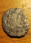
I wish I had a clearer closeup of that silver reale.

Thanks much Kenneth!

---

I was going to do a detailed look at sweep patterns today, but I didn't get it ready yet.  It will take some time for me to make the illustrations.

I've talked before about the importance of knowing the area of sensitivity for your coil.  The area can vary for different areas of your coil.  Here is a simple illustration.


A concentric coil will typically have a more cone shaped area of sensitivity.  It will be most sensitive near the center of your coil.

A Double D coil will have an area of sensitivity that is consistent from the front to back of your coil.  A target under the front or back of the coil will be detected about as deeply as a target that is under the center of the coil.

I haven't always found that to be true when I personally tested coils, but that is what you'll see in the literature.  I believe in mapping the area of sensitivity for a coil by using an air test.  Move objects under different areas of the coil and see what kind of depth you get under different areas.

I've had some coils that for which the area of sensitivity was very wide.  I could detect targets to the edge and beyond.  Other coils on the same detector wouldn't do that.  In any case, it is good to know what the area of sensitivity is for the coil you are using.

If you have a concentric coil with a cone shaped area of sensitivity and make three sweeps without overlapping your sweeps, you'll be missing half of the area you thought you covered.

Lets say you have a coil that has a cone shaped area of sensitivity and you make three sweeps but are not careful to overlap each sweep.

You can see from the above illustration that you would be missing about half the ground that you thought you had covered.  A lot of overlapping would be required to get maximum depth over the area you are covering.

No matter what type of coil you have and no matter what the literature says about it, I recommend personally mapping out the area of sensitivity for you coil.  You will then know for sure what you are working with and what you need to do.

---

Three Systems Shown on the National Hurricane Center Map.
Here is the National Hurricane Center outlook text.

1. A weak area of low pressure, associated with a tropical wave located
a little more than 900 miles east of the Lesser Antilles is
producing disorganized showers and thunderstorms. Although some
slight development of this system is possible today or tomorrow, by
Thursday, upper-level winds are forecast to become unfavorable for
tropical cyclone formation.  This disturbance is expected to move
slowly westward across the tropical Atlantic Ocean for the next
several days.
* Formation chance through 48 hours...low...20 percent.
* Formation chance through 5 days...low...20 percent.

2. Shower activity associated with a surface trough interacting with
an upper-level low near the north coast of Hispaniola northeastward
over the southwestern Atlantic has increased a little since
yesterday.  Little, if any, development of this disturbance is
expected during the next few days while it moves west-northwestward
across the Bahamas and the Florida peninsula. However, environmental
conditions could become a little more conducive for development
when the system moves into the Gulf of Mexico over the weekend.
Regardless of development, this disturbance will produce periods
of locally heavy rainfall across the Bahamas through Thursday, and
across Florida on Friday and continuing into the weekend.
* Formation chance through 48 hours...low...near 0 percent.
* Formation chance through 5 days...low...30 percent.

3. A tropical wave located just off the west coast of Africa is
expected to move quickly westward during the next several days.
Some slow development is possible late this week and over the
weekend when the system is several hundred miles east of the
Lesser Antilles.
* Formation chance through 48 hours...low...near 0 percent.
* Formation chance through 5 days...low...20 percent.


So it looks like Number Two could move across Florida, but probably not as a strong storm.

Keep an eye on these.  It won't be long before we get into the Fall season, which is when we got some of our most productive storms in the past, including the famed Thanksgiving Storm of 1984.

---

Happy hunting,
TreasureGuide@comcast.net


Wednesday, December 19, 2018

12/19/18 Report - More On The Legendary Thanksgiving Storm of 1984. Miscellaneous Comments On A Recent Episode of Oak Island.


Written by the TreasureGuide for the exclusive use of treasurebeachesreport.blogspot.com.

I've posted information before about what caused some of the best-ever Treasure Coast beach detecting that occurred during the Thanksgiving Storm of 1984.  You've probably heard some of the stories about the treasure found on the beach after that storm.  I've posted some of that in this blog.  People said the information I posted about the storm really helped them, so today I have more of that.  Dale J. sent me a link to The Florida East Coast Thanksgiving Holiday Storm of 1984 by Raymond Biedinger, Clifford Brock,  Federico Gonzales, and Burt Sylvern.  Betweent that report and the one I previously posted, I think you'll understand what it takes to really uncover a lot of old beach treasure.

Here are a couple paragraphs from that report.

The meteorological conditions just described produced one of the most damaging storms to affect the eastern coastal sections of Florida during the past several decades. Much of the damage from Fernandina Beach southward to North Miami Beach, nearly 400 miles, was caused by the easterly winds of gale force with gusts as high as 60 miles an hour blowing for nearly four days. This action of the wind over the ocean produced shoreward moving swells of around 20 feet which pounded the Florida east coast and produced the most severe beach erosion in recent years in many areas. An example of the destruction was the reduction of the newly completed l100 foot pier at St. Augustine to 300 feet. Sand dunes were obliterated leaving barrier islands void of any natural protection against the next onslaught of a coastal storm in the future. 

To add to the destructiveness, the highest monthly astronomical tide period coincided with the highest period of storm tides which occurred on the morning of Thursday and Friday, the 22nd and 23rd. All of this produced tides 4 to 6 feet above mean yea level (MSL} at times of high tide. In some places, this was the highest tide in the last 30 years. Alt Mayport, Florida, just north of Jacksonville, the tide of 5.2 feet above MSL was the third highest tide of record. Much of state road A1A, the famous coastal highway, was closed in Indian River County between Vero Beach and Sebastian Inlet because of high water. In this area several beach front buildings collapsed, and 600 to 1,000 people were ordered to evacuate their homes. In Palm Beach County, five blocks of A1A were seriously damaged by the high tides and heavy surf. Bridges were closed because of flooded approaches which caused some barrier islands including the large Hutchinson Island to become isolated for periods of time around the time of high tide. In the storm's aftermath, severe coastal beach erosion stretched from Jacksonville to Palm Beach. Several counties were declared emergency areas by the Governor of Florida. The storm tides and high surf alone combined to produce property damage at first estimate of over 8 million dollars along the coast. Figures 18 and 19 show this damage assessment to both public and private property in the individual counties along the coast. (Later poststorm reports from the Florida Department Natural Resources...

If you want to learn more about that, here is the link.

https:/www.weather.gov/media/mlb/marine/Nov_1984_storm.pdf

Thanks Dale!

I added the underlining to the above.

And if you want to see my previous post on the Thanksgiving Storm along with excerpts from another report, here is that link.

https://treasurebeachesreport.blogspot.com/2015/06/61715-report-can-storm-uncover-as-much.html

---

I woke up this morning from a dream in which I was hunting through some good shell piles and finding some old things.  I guess my little walk yesterday and my planned walk today was on my mind.

---

Yesterday I saw most of episode six of season six of the Oak Island TV show.  It provides so many positive and negative treasure hunting lessons and illustrations that I have to comment on it.  They have really picked up the pace this season.

My first impression is that the word "theory" has suddenly become very popular on that show.  It is used frequently now.    A simple word count of the transcripts could quickly confirm or deny my impression if somebody wants to do it.  If true, it indicates a new positive direction for them, in my opinion.

The advantage of "targeted" drilling based upon the seismic data was clearly demonstrated.  The hypothesis of a void of the type expected, or hoped for, was not supported in this case, but a clear answer was provided with a relatively high degree of confidence.  You won't get that with random searching.   If you have a clear hypothesis to test, you have a much better chance of coming up with a clear answer so  you can move on with the additional information.  In this case, they did not find a void where one was expected, but they effectively conducted a test and learned something from it.

Well-defined questions lead to effective tests that result in answers.

I'm encouraged that they had some real expert analysis instead of the Dr. Lori kind of thing.  It seems they are really pouring money into the project this year.

I would have liked to have a level of confidence expressed concerning the age and mining location for the lead cross.  90%, 80%, or something like that.  Perhaps I missed it.

As I've said many times before, because something might have been produced at an early date does not mean that it was lost at such an early date.  We often think in terms of today's standards in which we buy something, use it and throw it away in a very short time, but things can be used or kept for hundreds of years before they are lost or deposited.  That is especially true of treasured antiques and artifacts.

I once bought a widow's mite from an antiquities dealer as a Christmas gift for my mother.  If it was lost and somebody later found it, they would be wrong to conclude that the 30AD coin was brought to America and lost in 30AD.   An old item could be lost or deposited almost any time up until the time it was found.

I'm curious why the cross was made of lead instead of gold or some other metal considering the possible context of a large treasure hoard.  Why not something more precious?  Does the lead have a symbolic significance or purpose, or was the cross simply fashioned by someone out of scrap lead - perhaps a type of soldier art.  It seems to me that it might have been once nailed to something through the head.

There was a piece of scrap lead they found in an earlier episode, which looked quite recent to me.   Neither seemed to show much evidence of salt water corrosion.

Another thing you can take from the lead cross is what I always say about discrimination.  Lead and other items that are NOT coins or gold or silver can be very good finds.  Anyone who got that item under their coil would definitely detect it unless they discriminated it out.

Location, location, location!

---

Tomorrow the surf will be up to two or three feet, but the tides will start to get a little bigger.

I'm going to try to take a walk to look for more bottles and things if I get the chance.

Happy hunting,
TreasureGuide@comcast.net

Wednesday, November 21, 2018

11/21/18 Report - The Importance of Tracking Beach Movement Over Time. Big Surf Predicted.


Written by the TreasureGuide for the exclusive use of treasurebeachesreport.blogspot.com.

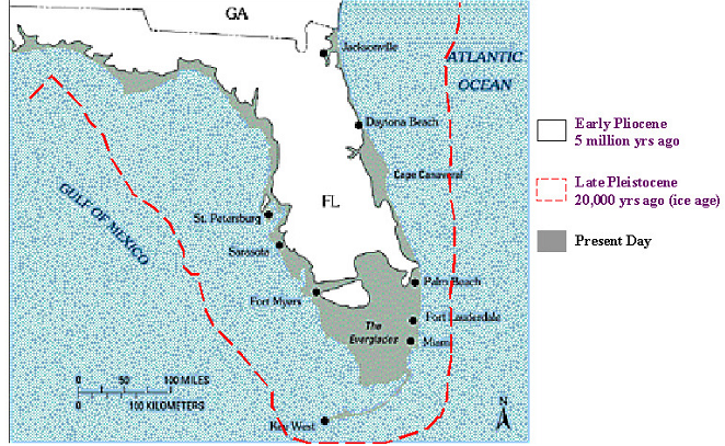
Florida's Changing Coastline.

Beaches move.  Beach sand moves constantly.  It is a complex choreography with countless moving grains - some moving in one direction and others moving in another direction - some moving rapidly and some moving slowly.

Sand is moved by wind and water.  I'm sure that doesn't surprise you, but the consequences are important for the beach hunter.

People talk about how items sink on a beach.  As I've argued before, items on a beach rarely move if the sand doesn't move.  Prove it for yourself.  Get a bucket of sand, put a coin on the top of the sand, and you'll be able to observe that a coin won't sink in resting sand.  Coins don't work their way down into sand like sand-fleas, moles or worms.  The biggest factor is the movement of the sand.

If I wanted to find old things at the beach, one thing I'd really like to know is the history of the beach and how it has moved over time.  The beach won't be where it used to be.  The sand will come and go many times in a year.  Beach could be a long distance from where it used to be. And even when the surface looks the same, the sand could have eroded several times and then filled again.  As that happens, objects will generally tend to settle lower.

I can remember times when local different Treasure Coast beaches were very different from what they are like today.  I'm sure you can too.  I remember, for example, when an old concrete foundation was exposed at the water's edge between John Brooks beach and the condos to the north.  I only saw it once, but I'm sure it is still there.  Of course the waterline is not where it was then.  In the same area, there was also once a line of tree stumps in the shallow water.  I haven't seen them again either.  The water line at that time was much closer to the condos than it is today.

I'd love nothing more than to have a overhead stop-motion video history of the beach changes.  You'd see the beach move in and out, slowly sometimes and at other times very quickly.

People often use stationary landmarks to judge beach changes and determine when old items might appear.  It wasn't long ago that I posted how people used a car frame up by Vero to judge when hunting would be good.  That car frame is gone now, but it provided a marker to estimate the movement of sand.

The illustration at the top of the post shows how much the Florida coastline has changed.  It changes year to year to, and even day to day.  Those changes are important to the beach hunter.  Many old objects that were once in the water are now covered by the beach, and other objects that were once on the beach are now in the water.

The beach can change quickly when there is a big storm.  Here are some photos of changes caused by hurricane Michael that did so much damage not too long ago.


The photos show how one section of beach disappeared in a very short time.  Here is the link for more about that.

https://www.usgs.gov/news/and-after-coastal-change-caused-hurricane-michael

Here is another example from the same article.


These changes caused by Michael are easy to see.  Most of the time the movement of sand occurs more slowly, but it does occur nearly continually. I'm sure that some of the erosion that occurred during Michael has been reversed by now.

I'm often amazed that people, sometimes conducting very big operations, are so far off simply because they failed to take into account beach movement. Remember, the beach is now different than it was a year ago, ten years ago, and certainly hundreds of years ago.

One of my old favorite shallow water hunting spots is now under the beach and the new waterline is out at least a hundred yards from where I hunted in the water about thirty years ago.  A beach renourishment project caused that.  If I went back there today and walked out into the shallow water, I'd be far from the area where I used to hunt and the old stuff would be deeply buried under the beach.

If you have a beach target that is dated to a general time period, one of the first things I'd recommend is that you do some research and try to find maps from that time and figure out where the beach was then relative to where it is now.

---

A six to nine foot surf is predicted for Friday.  That is a bit of an increase since yesterday.  It could get interesting.

Source: MagicSeaWeed.com.

Happy Thanksgiving,
TreasureGuide@comcast.net


Friday, July 6, 2018

7/6/18 Report - Hurricane Beryl. Pac Man Cob. Inspecting Coins. Two Blown Bottles.


Written by the TreasureGuide for the exclusive use of treasurebeachesreport.blogspot.com.

Mexico Minted Half Reale
 This is what I call my Pac Man cob.  If you are old enough, you might know why.  It is because of the shape.

I didn't have this one labeled with the time and place of the find, although I know it was a John Brooks beach find.  I now have no idea when it was found.

Like many beach found cobs, this one is not in good shape.  A lot of the design is missing, and what is there is not easy to decipher.  There are things you can do to help you see details that otherwise might be difficult to see.

What I want to show today is the effect of lighting.  I didn't do any sharpening or enhancement to the photos, which can also be a big help.   I just took the photos with the camera looking straight down.  The only thing I changed was the lighting.  You might be able to make out the partial cross in the photo above.

For the first photo, the light was coming from directly above the object and reflecting back at the camera.

Same Cob With Different Lighting
 Photos give a two dimensional view.  That means you can lose valuable information that you would have if you were looking at the item with your two eyes, which gives you a stereoscopic view.

One way you can get more dimensionality is by changing the lighting.  The photo immediately above was made with the light shooting from the the south.  You can see the shadow above the cob.  You can also see how that highlights the horizontal bar of the cross.  The light reflects back from the south-facing raised edges.

The glare from the surface of the cob was also reduced.  Compare the view of the surface you get in this photo compared to the one at the top of the post.

Same Cob With Lighting From the Left.
In the bottom photo, the light was coming from the left, which bring out the vertical bar more, but you can't see the horizontal bar so well.

My point is that you can bring out different details by changing the direction of the lighting.  Lighting is the most important thing in photography.  It can also help you see things that are too small to see with the naked eye.

When I want to see small details on coins that I might not be able to see with the naked eye, whether it is a modern penny or an old cob, a close-up image and strategic lighting can be a big help.

---

Two Old Green Hand-Blown Bottles.
I recently showed two old hand-blown brown beer or ale bottles with applied lips.  Here are two more old bottles found on the Treasure Coast.  These two also have applied lips, and probably date to the late 19th century.

The one on the right was the first blob top bottle that I found and was my favorite bottle find until I found the Muhler bottle.

Lip and Neck of the Light Green Bottle.

After the bottle was blown in a mold, the blow pipe was broken off the bottle and a hot blob of glass was placed on top of the bottle where is was shaped and formed.

Lip Forming
Tool.
Here is a diagram of a lip-forming tool. It was stuck down into the neck of the bottle and turned to shape the blob of glass that was to become the lip.

Sure would be nice to find one of those.

The process often led to fine bits of hardened glass adhering to the inside of the neck.  I can see that very well on both bottles but more on the dark green bottle.  Those kinds of things are nice little details that you can easily miss, but they give you a real sense of how the item was made.

Here is the source link for the picture of the tool.  https://sha.org/bottle/finishes.htm.  You can also find that link on my reference link list.  Great site that tells a lot about old bottles.

I really like these old hand-blown bottles.  You can see the bubbles in the glass that stretched along with the glass as it was being shaped.  Both of these green bottles have long bubbles in the neck.

It is very much like coins.  I enjoy seeing the details on the coins that show how they were made.  Coin errors often illustrate the process.  I'll talk about that more some other time.

The bottoms of these two green bottles are very similar.  You can see where the pontil was and how it was smoothed out.

Bottom Light Green Bottle.
Notice bubble just left of 12:00 position.
The bottom on the light green bottle (above) is very lopsided.  The right sie is much higher than the left.  That is much of the charm of hand blown bottles.  Like hand punched cobs, you can see the workmanship.  In the case of the bottles, it was a glass blower and his assistant.

Whether it is coins or bottles, I would encourage you to look for the little things that can tell you so much.  Even modern coins show errors and other small details that are the result of decisions made by individuals.

More views of the bottles will be available in TGBottleBarn.blogspot.com.

---

It is that time of year.  The Atlantic is heating up.  There is a tropical depression in the Atantic and a hurricane.

The topical depression probably won't affect us.

The hurricane is Beryl, which is headed east towards the Gulf.  Of course there is a good chance that it will turn north, but the predictions I've been hearing say that it will fall apart or turn north and miss us.  If anything, it could produce some rougher surf for us this weekend.

Time to watch for the next storm that might turn out to be like the legendary Thanksgiving Storm of 1984.

Hurricane Beryl
Source: nhc.noaa.org
Happy hunting,
TreasureGuide@comast.net

Saturday, May 26, 2018

5/26/18 Report - Whatzit Coin for ID. Bottles and Huge Insulators Found. Alberto. One Reader Who Suffered Rattlesnake Bite.


Written by the TreasureGuide for the exclusive use of treasurebeachesreport.blogspot.com.

Very Mangled Coin.

I found this very mangled coin.  It is one of the most mangled that I've seen.

The photos show more detail than the actual coin, which only shows very very little surface detail if you get the lighting just right.  In fact, looking at the actual coin, I didn't see any surface detail at all until I caught the light just right and could barely make out part of the face.  I thought it might just be a slug or blank for a long time, but after seeing part of the face, I tried to clean it some and then took the photos, and I could see much more with the photos than the unaided eye.

You can see part of the words "LIBERTY" and "GOD WE TRUST"  in the photo above.


Two Photos of the Back of the Same Coin.
The above photo appears to show "10 60" and "KES" along with a boats bow with people standing on it and a bird overhead.  At least that is what I think I'm seeing.  You have to look close.


The camera angle is slightly different and I think you can see how much difference that makes in what you can see.

I could use some help in identifying the coin.  I don't know why I need to, but it has become a bit of a puzzle for me.

It weighs more like a nickle than a quarter.  In the bottom photo, I think I can see either 2005 or 2007.

Notice how a slight change in camera angle can make additional details more clear.

By the way, these photos were created using a Cannon EOS Camera (Digital Rebel XTi) with the lens that came with it (EF-S 18 - 55mm).  No close-up lens or anything special was used.  I was pleased with the photos, and a small amount of digital enhancement.  I could see way more in the photos than I could see with just bey looking at the coin.

I'm hoping someone can tell exactly what coin that is supposed to be. Thanks.

And how do you think it got so mangled?

---

I was clearing an area covered with brush and vegetation this morning and found a bunch of bottles and some insulators.

Here are a few.

A Couple Bottles Found This Morning.

The clear one is about a foot and a half tall.  I don't have any idea what it might have held.

Insulators and Bottles Found This Morning.
There were a lot of milk bottles.  You can see one of those in the background of this photo.

I haven't looked through those bottles much yet.

----

I add this rattlesnake story to emphasize what I said yesterday about being careful.  In Florida we have some very deadly snakes.  Here is Brain B.'s dramatic story.


Hello,

I'll share a true story with you regarding being bitten by a rattlesnake. When I was 15,I broke my ankle playing basketball at school. The cast stayed on for 6 weeks up to my knee.I begged the doctor to take it off on the evening before Thanksgiving. I was his last patient of the day. He xrayed it and said it could come off so I could hunt Thanksgiving long weekend but wasn't due off until the following week.

The next day around 1pm before the big family dinner I was hunting up near Tomoka State park. I stepped on a palmetto fan laying on the ground. As soon as I stepped off of it something sprung up and latched onto my left calf up high near my knee.

I grabbed it and yanked it off,as my buddy ran away from my scream. I climbed a small oak quickly(funny how your brain tells you to run and get off the ground) and rolled up my pant leg. I heard the rattle then. There he was coiling around my shotgun laying on the ground.

My friend threw pine cones at it and I slid the gun to me and shot it many time. 14 rattles and maybe 7 feet in length. Fang marks were 2 1/8 apart. My buddy ran for help as I limped out of the woods with rattles in hand.At the hospital they called my parents and asked permission to treat me. Guess what? I was allergic to the horse serum as they prick you a couple times with lose dose to see how you react.I was screwed. 

They tried to get in touch with Ross Allen in Miami for a pint of his blood. No luck. For 13 days I stayed in Halifax Hospital while the venom ran its course. For the first 2 days they kept me awake, Low dose of morphine for pain. I turned black,green,yellow and blueish on half my body. My whole left side from toes to neck was twice the size of the right side. A perfect dividing line one side chest bigger than right side.

When you are allergic to horse serum there is nothing else they can do without getting someone else to give you a pint of their blood that has been bitten before and allergic to horse serum too. You body has to build up on it's own.

Yes,the doctor whom cut the cast off that evening before stopped my room as it made the papers and throughout the community. We laughed about the the timing of cast coming off early and getting bit on the same leg. For the next 3 months I was on crutches and limping along. To this day I can take a pencil tip and still pinpoint to the exact location of where the fang marks were as they are sensitive.No surgery was needed as they wanted to cut my whole leg open and remove the poison  dead tissue. I thank my dad for not allowing them to do that as my leg is 100% today and everything is normal.When you are bitten you feel light headed,like you are walking on a hot day ready to faint. You feel disoriented as the poison hits your system. Worse part? The force of the strike like punching nails into your calf with a hammer. The rest isn't bad at all. Thanks and enjoy your weekend.


----

7 AM Saturday Update.
Source: nhc.noaa.gov
The path of Alberto has been steady.  It looks like it will hit the Florida Panhandle as a storm.  Probably no big deal.

It looks like we'll get some rainy days from it, but no big effect on beach conditions.

Happy hunting,
TreasureGuide@comcast.net

Tuesday, March 6, 2018

3/6/18 Report - Understanding Why Big Waves Sometimes Lead To Finds and Other Times Not. Mystery Find Identified.


Written by the TreasureGuide for the exclusive use of treasurebeachesreport.blogspot.com.

After all of the big surf the past few days, there was more accretion than erosion along the Treasure Coast.  I talked about a couple of the reasons for that yesterday.  I mentioned the amount of sand in front of the beach that was absorbing most of the wave energy before the waves hit the beach, along with the angle of the waves.

You've probably heard of the legendary Thanksgiving Storm or 1984.  I've mentioned it several times before and I posted the exciting story of one person that was there that day.  I also posted a NOAA report that explained why that storm damaged the beaches so much.  While people are wondering what happened and why the recent waves didn't do much for us, I thought it would be a good time to post some of that report again.  It really explains what happened back then and why it happened.

Here is part of that NOAA report.

...The meteorological conditions just described produced one of the most damaging storms to affect the eastern coastal sections of Florida during the past several decades. Much of the damage from Fernandina Beach southward to North Miami Beach, nearly 400 miles, was caused by the easterly winds of gale force with gusts as high as 60 miles an hour blowing for nearly four days. This action of the wind over the ocean produced shoreward moving swells of around 20 feet which pounded the Florida east coast and produced the most severe beach erosion in recent years in many areas. An example of the destruction was the reduction of the newly completed l100 foot pier at St. Augustine to 300 feet. Sand dunes were obliterated leaving barrier islands void of any natural protection against the next onslaught of a coastal storm in the future.To add to the destructiveness, the highest monthly astronomical tide period coincided with the highest period of storm tides which occurred on the morning of Thursday and Friday, the 22nd and 23rd. All of this produced tides 4 to 6 feet above mean yea level (MSL} at times of high tide. In some places, this was the highest tide in the last 30 years. Alt Mayport, Florida, just north of Jacksonville, the tide of 5.2 feet above MSL was the third highest tide of record. Much of state road A1A, the famous coastal highway, was closed in Indian River County between Vero Beach and Sebastian Inlet because of high water. In this area several beach front buildings collapsed, and 600 to 1,000 people were ordered to evacuate their homes. In Palm Beach County, five blocks of A1A were seriously damaged by the high tides and heavy surf. Bridges were closed because of flooded approaches which caused some barrier islands including the large Hutchinson Island to become isolated for periods of time around the time of high tide. In the storm's aftermath, severe coastal beach erosion stretched from Jacksonville to Palm Beach. ...

At the West Palm Beach weather office, a new station rainfall record was set on Thanksgiving Day for the greatest amount in a calendar day, 7.41 inches....

Another factor was that these strong onshore winds continued for many days. Winds of near gale force (about 40 miles an hour) began blowing along the north Florida coast the evening of the 20th. They did not subside until late on the 24th. Therefore, much of Florida experienced strong onshore winds for about 4 whole days. These winds were frequently between 30 and 40 miles an hour. The direction of the winds was from the north northeast which is probably the best angle of incidence for beach erosion along the coast from Fernandina Beach to Palm Beach. The coastline south of Palm Beach was spared from most of the adverse effects of the storm because the wind was actually blowing offshore throughout much of the storm. However, this northwest wind caused significant damage to the coastlines of the western Bahama Islands Friday and Saturday. This was all due to the position of the storm center remaining over Grand Bahama Island from early Thursday morning through early Saturday...

As noted earlier, the time of the month that the storm occurred was coincident with the highest astronomical tides of the month and nearly the highest spring tide of the year. Tide tables indicated that the highest predicted tides for the month of November fell on the mornings of the 22nd and the 23rd, exactly during the time of the highest storm tide. Reports from the storm survey teams of the Florida Department of Natural Resources indicate that the storm tide was over 6 feet above low mean water. Tide gauge readings at Mayport were 7.5 feet above mean low water or 5.2 feet above mean sea level. The one factor of the storm episode which magnified the entire situation was the nearly stationary nature of the storm for 3 days. This lack of movement produced the prolonged onshore winds which resulted in at least 4 days of heavy surf pounding the shore. Portions of the coastline experienced 9 high tides during this period, with each succeeding high tide higher than the previous one, thus making the erosion of sand greater with each tide. These are the reasons for the extensive damage that resulted from this particular storm....

Before commenting, here is the link if you want to read the entire report.

http://www.srh.noaa.gov/images/mlb/pdfs/Nov_1984_storm.pdf 

Notice that the report says,  The direction of the winds was from the north northeast which is probably the best angle of incidence for beach erosion along the coast from Fernandina Beach to Palm BeachAs is often the case, the wind has been shifting the past few days.  It started from the north and one person said they saw some cuts (Saturday I think it was), but they disappeared a day later.  Often that is what happens when a front moves through: the wind shifts around as the front moves through.  As the direction changes the swells change and the sand moves one way and then another. 

Unfortunately we're going to continue getting changes in wind direction as another front moves through.  However, I'm still thinking the biggest problem is the tons of sand piled up in front of the beach. 

Knowing when and where to go isn't an exact science.  You can learn enough to improve your chances considerably, but there will still be hits and misses.  If you get it right every time, you're a lot better than I am.  I go out to check to see what is happening.  Sometimes I'm surprised and sometimes I see exactly what I expected.  If you go out after a long period of south winds and small surf, your chances of finding any old treasure coins is very slim.  As with many things, learning is a matter of probabilities.  In fact I say that skill is a matter of doing the things necessary to improve the probability of success.

I don't know if I've ever said this before, but I believe that heavy rains can add a little to erosion by agitating the top layer and cliff faces.  I have no idea how significant that might be, if at all.

I think the NOAA report on the Thanksgiving Storm is worth studying.  It tells you what caused one of the most legendary treasure beach days ever.

One factor they do not address is the longer term changes that occur over years or decades.  It seems to me that there are times when you have net erosion or accretion that occurs over a period of years.  I can remember times when that big sand bar was not in front of John Brooks beach and if you stepped off the front of the beach into the water there was a drop off.  There were pot holes right in front of the beach.  The bottom wasn't covered with a layer of sand.  That lasted for some years, but it hasn't been that way for at least a few years now.  In my opinion, that has a lot to do with why John Brooks has not been too productive in recent years.

---

We have consensus on yesterday's mystery find.  Lloyd D., Joe R., William M. and Bill P. all said it is a sheet music holder.  Thanks guys. 

No other ideas offered, so I think that is it.  Below is an example from Pinterest.


The holes were for attaching the shelf and some of them had other attachments for holding the sheet music firm, which explains some of the other holes.

The interesting thing would now be to see if there is a story behind it and how it ended up where it was found.

----

Happy

Wednesday, December 13, 2017

12/13/17 Report - All About Encrusted Objects. Sail Grommet(?) Find. One Man's Garrett AT Max Experience.


Written by the TreasureGuide for the exclusive use of treasurebeachesreport.blogspot.com.


Source of illustration: Master's Thesis (See link below)

Iron objects don't hold up well in salt water.  Besides rusting and corroding, they can eventually become totally covered by encrustation and eventually dissolve.

Those lumps of encrustation formed around old objects are commonly referred to as EOs (encrusted objects).  You'll miss a lot of them if you are discriminating iron, or you might discard them at first sight.

I find them interesting for a number of reasons.  One is figuring out what object is inside or was inside the clump before it dissolved.  Another is that a variety of objects can be in such a clump - including coins.

I posted one example that Darrel S. showed us of a reale attached to two bolts.  You probably also read my post on the 1984 Thanksgiving storm in which Clint described how he found a keg-size conglomerate that contained a bunch of amazing goodies.

The trouble is that it is so hard to tell what might be inside and not knowing if the object or objects survived at all.  Another problem is trying to remove the encrustation, if that is what you choose to do.

I found a resource that will help answer many of your question about EOs.  It is a Master's Thesis entitled Recontructing the Assemblage of Iron Artifacts From the Late Hellenistic Shipwreck at Kizilburun Turkey. 

The illustration above is from that thesis and illustrates the process that an iron object might go through.  There are a variety of factors that can influence the rate of corrosion and encrustation, so you can't estimate how old the object is by just looking at how much it has deteriorated.

When the object has totally dissolved, you can pour plaster or some other substance into the void and create a mold that will show you what the object looked like.

I think you'll benefit from quickly reading through the thesis.

Here is the link.

http://nautarch.tamu.edu/pdf-files/Rash-MA2012.pdf

---

Partially Encrusted Object
Find and photo by John C.
John C. sent me this picture of one of his finds since I had been talking a lot about sailing making and sail tools and related things.  He thinks it might be a sail grommet.

Interesting find.  Thanks for sharing John.

---

Steve from Sebastian ordered a Garret AT Max and shared his experience and observations.  Here is what he had to say about that.

Sadly...I had to return the new Garrett AT Max. They have a known screen issue of having un-viewable screens if you wear Polarized sun glasses, which I must. The AT Pro had this issue already. Too bad...it was a very nice machine. Probably not the best for wet salt beaches anyway. You had to do a special "7 step plan" that was not in the manual to tame it down (excessive falsing) on the wet salt sand beaches and in the salt water.

So... I now have a 185 page manual to digest on my new/used 2017, 10 month old CTX 3030! With all 3 coils and 3 CF shafts. I've come a long ways... from a Relco $19.95 kit, with a little plastic bag full of resistors and capacitors that you had to feed in through the little circuit board, solder and cut off the ends...to a powerful "walking computer" in the guise of a metal detector. That tracks your path on GPS, laying down "bread crumbs" so you don't miss any spots, and learn to walk in straight lines, and stores your "find points" with a touch of a button, that not only has the exact GPS coordinates, but the date and time, what reading the detector had over the target (like 12-43, ferrous/conductive scales) ...ratchet pin-pointing that keeps closing down the target strength on each pass to get you set up perfect...and on and on. Many things that I haven't even found yet!

And now...just tonight...I was contacted by Minelab to be the -first beta tester- to do test analysis on their first ever Apple Mac version software! Quite an honor for me.

Thanks for the report Steve. I always appreciate detector reviews. And congratulations on becoming a beta tester.

--

Happy hunting,
TreasureGuide@comcast.net

Thursday, November 30, 2017

11/30/17 Report - British Museum Acknowledges Contributions of Detectorists. Beaches on the Treasure Coast. Its a Small World.


Written by the TreasureGuide for the exclusive use of treasurebeachesreport.blogspot.com.

John Brooks Beach Yesterday.

Frederick Douglas Beach Yesterday
Both beaches were pretty sandy.

Darrel S. sent the following beach photos, which were also taken yesterday morning.

Wabasso Beach Yesterday.
Photo by Darrel S.
Between Seagrape and Wabasso Yesterday.
Thanks for sharing Darrel.

---

The British museum recently unveiled archaeological finds made last year by detectorists.  Among those finds is an very rare Iron Age Celtic helmet from the time Julius Ceasar first invaded Britain.   Below is a link to the article about that helmet.

https://www.theguardian.com/uk/2012/dec/03/detected-amateur-treasure-troves

---

I got a very late start on the blog today so I'm going to keep it short.

I have the identity of the USMC ring and another new find to look at.  I'll post more about both of those tomorrow.

I heard from a lot of people that said they really enjoyed reading about Clint's experiences during the 1984 Thanksgiving Storm and the 1991 hunt.

It is a small world.  I think I know exactly who the fellow was that found an 8-escudo on the beach right beside Clint.  That fellow did find an 8 escudo on the beach there at that time, and he also told me the same story about the guys on the beach with a machete.  The machete story is what jogged my memory.

I'll wrap it up for now and be back with more tomorrow.

Happy hunting,
TreasureGuide@comcast.net

Tuesday, November 28, 2017

11/28/17 Report - Ole Timer Talk: Clint. Amazing Beach Finds of the Legendary Thanksgiving Storm of 1984 and More.


Written by the TreasureGuide for he exclusive use of treasurebeachesreport.blogspot.com.

Today I'm going to post an email I received from Clint.  I might do a series of similar posts from ole timers who are willing to share.  I'll call it Ole Timer Talk (OTT).  There is no specific age or time period I'm looking for.  I'd say at least before the 21st century, as a minimum.  I've done a few of these in the past, but just decided to make it a regular thing if I can.

One thing that was different when I started metal detecting is that there was a lot less communication and a lot more secrecy.  There were clubs, but no one was going to tell you much unless you were their trusted treasure buddy.  It is so much easier to get information today and the metal detecting community is much more informed because of it.  Ole timers could be just as skillful and successful in the past, but they generally had to learn a lot  more on their own. Even though they were very skilled, I don't think they were generally as broadly informed.  Maybe that is just my own perception, because I was a lone wolf and thoroughly enjoyed experimenting and learning on my own, but I know I made a lot of mistakes and still regret some of them.

Times change, and that is one reason that it is good to record the experiences of the past, especially those that were never widely shared before.  Anyhow, I'm thinking I will start a series of posts like this if their are enough ole timers that are willing to share their favorite or not so favorite experiences. I don't know if there will be many or few or if they'll be often or rare, but I'll start it off today.

If you want to know what it was like, here is how one man experienced it..

Hi.

I would like to relate to your audience remembrances of hunting the treasure beaches of Treasure Coast in 1984 and 1991.

In 1984 near Thanksgiving, I left sunny mild Sebring for a day of fishing at Vero Beach…I also carried my Whites PI1000 as a alternate in case fishing was lousy.

Halfway to Vero, It became windy and cloudy. Two miles from Vero and the Palm tree fronds were almost horizontal from the wind.

I decided to heck with fishing…headed to Turtle Beach Access. Upon arriving, I was blown away by the number of people who were trying to get down to the beach but the waves were crashing into the Berm and you could see debris ( dock parts, palm trees, large wooden boat trash) just flying south in the current as the tide rose and the waves got higher. Then some guys made it into the water but were being slammed into the berm and some were hit by debris. That ended hunting for a few hours.

Later that day, people could hit the beach but not really sure what was found. I do know that the berm was 4 feet high before I left to find a motel.

Next day, I made it to the beach and the berm was 8 feet high and the beach was flat. People were searching and I found my first Spanish coin…a 1/2 reale in very good condition. I will never forget the feeling when I turned it over and saw the cross.

No real finds yet so I returned to the Motel. Police were turning away people that did not reside on Johns Island but I had the motel info and I was allowed to pass.

The third morning, I made my way to Turtle Beach access again. It was a retreating tide but winds still avg. 57 MPH. tide was way out and there had to be 100 people on the beach.

My PI1000 suddenly stopped working (later found out the coil was soaked inside). I watched people scooping up all kinds of stuff and others digging up cannon. The beach had all kinds of ship wreck artefacts laying there. The Berm was now 12 feet high and possibly 20 feet back.

I cannot remember his name but I stood by a fellow with a Seahunter XL500PI who was trying to retrieve a signal in ankle-deep water. His second scoop netted a pair of pliers from the wreck. Following up on that signal he received another from the same hole and came up with a beautiful 8 escudo coin. I remember we both exclaimed an expletive at the sight of it.

Suddenly a wretched guy carrying a machete came up to us and said something to the effect that "a guy could get hit with a machete for that"… and we both made a retreat …fast!

I was bummed out because people were finding stuff everywhere and I had NO DETECTOR. I was watching two guys dig out a small cannon and someone named "Bull Durham" came buy swinging a detector and found a gold coin in the sand pile created by the two cannon retrievers. I finally decided to go home. As I was leaving, I saw three big lumps of concretion at the base of the berm. They must have weighed 80 lbs each. About the size of a beer keg.  I decided to take one home and struggled to get it to the car. Thought if it was something maybe I would come back in a few days and get the others (yea, RIGHT!LOL).

I took the "keg" home, soaked it in Muriatic Acid for 3 days and washed the material left in the plastic trash can. I Freaked out…there were 270 hand wrought ship spikes, 4 - 4escudo gold coins, and a handful of silver 4 and 8 reales. I made a gorgeous display of the ship spikes (some were in circles and some were S-shaped). This was the ships carpenter"s keg of nails. There were pieces of American Cedar and two pieces about 6 inches long of metal Banding. I went back to Vero 4 days after the storm and …yep…the other concretions were GONE!!

Since 12 feet of beach was washed out to sea, anything left at that level was covered over in 2 weeks. The only way any remaining treasure that was on that beach and out past low-tide could now be found is for the beach to erode further than 12 feet down which would probably be near rock bottom according to some old-timers I talked to.

I moved to Lake Worth in 1987 and started learning about beach and wave patterns. Watched how people reacted to waves and patterns of swimming and horseplay. I studied wave interaction at the tideline. and then I started finding lots of lost jewelry and coins. I even was able to find $20 bills floating just under the surface of the water, which led to me finding the metal bill holder in several instances.

I searched Jupiter Beach and Lake Worth beach exclusively and learned all the patterns there. I walked along the beach one winter day searching with my Seahunter XL500 and could easily recognize the sound of gold, but while I listened, my eyes roved. I spied a 6 inch portion of a pencil thick gold chain sticking up and moving about halfway between low and high tide mark. People were walking by it, oblivious to it. I pulled it up and it had a gold Maltese Cross as a pendant. I found gold nugget rings at the base of berms just laying there exposed.

In Winter 1990-1991, I met an old retired guy at LW beach and he was there every day. We were basically the only two working that beach on most days. In that particular time frame, a longshore current must have cut through from LakeWorth through to Jupiter Beach and for a month, He and I each filled a box with hundreds of old WWII era coins and (of course) modern coins. BUT…a case in point, one day we met at LW beach and the tide was rising with wind blown winter waves. We would meet at the beach center and walk in opposite directions for the length of the beach at the waters edge where the waves washed up, turn around and walk back to the center and show each other our finds, then turn around and repeat…for at least 10 times. I found at least 15 gold rings with stones and 5 wedding bands, 2 necklaces. He found near the same but I think he found more.

That easy picking abruptly ended when the cut out further finally filled in. One thing I noticed was on a sloping beach, sometimes I would see what looked like a yellow pencil rolling up the beach with a wave and rolling down the beach following a wave. I would grab these items (3 in my time in Florida - 3-1/2 years) and they turned out to be gold Herringbone necklaces. Apparently, the nature of a herringbone lends itself to be straightened out by tiny grains of sand filling in the spaces (joints) and then the necklace can follow a wave. Also, I learned that when there is seaweed in the surf on a rough day, that as the wave crashes into the beach carrying seaweed, any necklace that gets roiled in the wave- weed combo gets caught up in the weed and winds up at the high tide line as sea wrack. Always run your detector (and eyes) over the wrack line.

As for the coins I found…I sold them in Maryland to get funds to buy a home.

I retired from the VA in 2010 in SC and drove to all my favorite beaches to detect. I was shocked to discover that I could NOT search in the water within 3000 yards of a shipwreck. Most beaches were sanded with renourishment sand. I went to LW beach and searched in the water. I could not understand why the beach out in the water was full of potholes (thousands it seemed), then I realized that with gold prices so high, people had descended on the swimming beaches and wrecked havoc out in the water.

I left and never returned. I will soon relocate to NC and be closer to Virginia Beaches and DelMarVa (Coin Beach). I then can use my MineLab CTX 3030 and even search rivers in inland areas for lost stuff at river crossings (will require Library and Historical research).

Best of Luck to all who endeavor to the refrain of…"Today's the DAY" !!!


Thanks for sharing Clint!

---

The surf tomorrow will just a little bigger - something like two to four feet.  The wind will be from the east.  Beautiful beach weather.

Send me your Ole Timer Talk.  I can't guarantee I'll post every one that I get.  I'll just exercise my own judgment, which can include a lot of different factors.   Its nothing personal if I don't post a particular submission.  I just post what I feel like talking about.  Remember this is just a fun volunteer activity for me.  Maybe I won't even get another submission.
.
Happy hunting,
Treasureguide@comcast.net