Showing posts with label west coast. Show all posts

Saturday, September 9, 2017

9/9/17 Reportt - Saturday PM Update Added - Irma Trending Towards The West Coast of Florida. An App or Two That Will Help You Get To The Beach.


Written by the TreasureGuide for the exclusive use of treasurebeachesreport.blogspot.com.
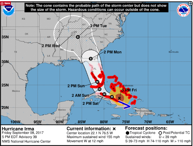

Source: nhc.noaa.gov
As you might be able to tell from the NHC track above, as of yesterday afternoon, the track moved more to the west.  coming in closer to Naples than Miami, and expected to proceed up through the state closer to Tampa than Canaveral.  If that is what actually happens, the Treasure Coast won't get the kind of damage that it would if the track stayed more east.

Now they are concerned about the storm surge that might occur on the Florida west coast.

Our surf predictions have decreased too.

Source: MagicSeaWeed.com
Yesterday they had something like a 22 foot preicted surf, now the biggest is 14 feet.  That is still to occur late Sunday.

Fourteen feet is still a lot more than the two or three feet that we have been getting most of the summer.

If the current MagicSeaWeed predictions are correct, we're not going to get the north winds either now.  Instead they will be east/northeast but mostly east.  That means that not only will the water not be as high into the dunes, but we'll probably get less erosion.  I'm not saying we won't get any.  We almost certainly will get some at various locations.  And it doesn't always take cuts to produce cobs.

After the storm and the east winds pass, we'll quickly be back to south winds - again if the predictions are correct.  That would mean that the beaches would start to refill again.

All of that, of course, is based upon what they think Irma is going to do, which might or might not be correct.  We'll see.

I've heard some say that we won't have much damage to buildings. I wouldn't mind that.  They are saying it will be more of a tree thing.  I won't mind less property damage.  Maybe - just maybe - the damage will be light enough that the beaches won't be closed.  Again, we'll see.

The predicted track could change again, but I don't think it will change much.  The models are agreeing more and the changes seem to be less frequent and drastic.

---

In following Irma I found some good web sites and mentioned them.  Some I posted.

One very interesting thing I found is a traffic app.  Go to googlemaps.com.  From the menu select the "traffic" option.  You will then see a map showing how heavy traffic is on the roads.  That is useful.
One day the Turnpike was jammed and traffic at a crawl or less at a lot of locations. You could take a look at the web site and choose another route if you found one that was moving better.

I saw there was a slow down at a corner near my house, so I went out and looked down the road to see it.  At the time I didn't know how it was done, but I did see the slow moving cars represented by a red line on the map.

You might wonder how google can show the traffic flow for roads all over the state and country.  The answer is they can track people with Android phones and how fast or slow they are moving, and of course they can tell where they are.  That is pretty amazing, but you might not want to think you are being tracked like that.  You don't have to because you can turn off the location data from your phone.

Check it out.  I found it to be a very useful web site.

Before you can do any metal detecting, you have to get there.  You might also like Gas Buddy, which will tell you where they have gas and the price.

---

I received some nice emails from some of the fine and thoughtful people that read this blog.

Thanks to all.

Janine K. sent the following message.

Thinking of all you Floridians and sending thoughts for a safe outcome for all. 

Thanks Janine!

---

Saturday 5 PM Update.

Beach erosion has begun on Fort Pierce beach but the bridges are closed - residents and business owners are among those permitted on the island.

The wind and surf is increasing - mostly from an easterly direction.


Be safe,
TreasureGuide@comcast.net

Tuesday, September 5, 2017

9/6/17 Report - BIG Surf Predicted for Treasure Coast. Watching for Irma. Updated After 8 and 11 AM advisories.


Writtten by the TreasureGuide for the exclusive use of treasurebeachesreport.blogspot.com.
Predicted Surf for Fort Pierce Area by MagicSeaWeed.com.


It seems to me that the National Hurricane Center has done a good job of predicting the path of hurricanes in recent years.  Still, last year we expected Matthew to hit the Treasure Coast and was surprised that it hit farther north.

We are still days away from the center of Irma and can't tell where it is going to turn.  The National Hurricane Center reminds us not to focus on the exact forecast track, though, especially at the longer ranges, since the average NHC track errors are about 175 and 225 miles at days 4 and 5, respectively. That is a big range.  Some models still have the track going east of us, others to the west of Florida, and some right up the middle of the state.  As a result we know very little at this point other than the fact that there is a still lot of uncertainty concerning where Irma will go.  

From the MagicSeaWeed web site it looks like we will have a big surf.  Above you can see the predicted surf for the Fort Pierce area.  It is big.  Very big.

On Sunday, when the surf is predicted to be near peak, it is also predicted to be from the north.  The beach will be very dangerous.  The beaches might get more eroded than during Francis and Jeane. Still, don't go out there until it is safe. They will probably close the bridges and beaches.  Wait until it is safe.  Think of life and safety first.  Help your neighbor.

In case you haven't found out for yourself yet, a lot of stores are already out of batteries and water.

I've been waiting for some clarity on the likely track of Irma, but haven't got it yet.  It seems to depend a lot upon when it will turn north.  As I said, some models have it going off the east coast, models have it going off the west coast and some models have it going right up through the state.


Position of Irma on Sunday at 5 PM if the GFS model is correct.
Source: Ventusky.com

Position of Irma on Monday at 2 PM if the ECMWF model is correct.
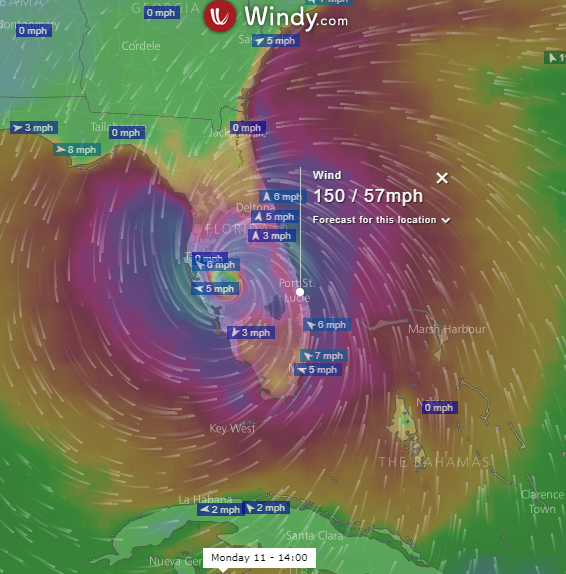
Source: Windy.com.
As you can see from the two images above, different models predict different paths.  The GFS model used for the first image is commonly used and is referred to as the American model.  It shows the hurricane heading north, right off of the Treasure Coast.  It wouldn't take much change for it to be right over the Treasure Coast.

Perhaps the most highly regarded model seems to be the European model.  That is shown in the second image, which shows Irma over by Tampa on Monday.

These two models are now a little closer than they have been at other times in the past couple of days, Unfortunately, both of them are very close to us.  

One model has the hurricane moving more quickly than the other.  GFS has it near us on Sunday, while the ECMWF shows the center nearest to us several hours later.

The models are still wiggling around quite a bit.  The next time I look, the results might be very different.  And there are other models showing different tracks.  It is really hard to tell at this point where it might go.


Source: nhc.noaa.gov
This is the National Hurricane Center track as shown after the Sept. 5, 11 PM advisory.  It looks closer to the European model.  

After the 5 AM advisory, they changed the nhc track to go up the middle of the state.  It looks like they are splitting the difference between the European and American models.


New Irma NHC Track After 5 AM Advisory.

After the 8 AM Update, I looked at the GFS and European model and both are now to the east of the Treasure Coast, but the European model is a little closer to the coast than the GFS.  After the 8 AM update, those two models seem to be converging.


Source: wunderground.com
The GFS model is shown above in red.  I snipped this at about 8:30 AM.  The European model isn't one of the ones shown here, but you can see the UKMET model runs right along the coast.   The general trend now seems to be more to the east.  I have no problem with that.
---

11 AM NHC Advisory

The Irma track posted on the NHC web site after the 11 AM advisory is very much like the UKMET model that that you can see in the picture  .  NHC now shows a track moving along the east coast of Florida and very much over the Treasure Coast (below).

Source: nhc.noaa.gov
The new NHC track is closer to the European and GFS models that I showed earlier too.

I hope the eastward trend continues.  I don't want to see the eye-wall going right over us.


Be safe,
TreasureGuide@comcast.net