Writtten by the TreasureGuide for the exclusive use of treasurebeachesreport.blogspot.com.
 |
| Predicted Surf for Fort Pierce Area by MagicSeaWeed.com. |
It seems to me that the National Hurricane Center has done a good job of predicting the path of hurricanes in recent years. Still, last year we expected Matthew to hit the Treasure Coast and was surprised that it hit farther north.
We are still days away from the center of Irma and can't tell where it is going to turn. The National Hurricane Center reminds us not to focus on the exact forecast track, though, especially at the longer ranges, since the average NHC track errors are about 175 and 225 miles at days 4 and 5, respectively. That is a big range. Some models still have the track going east of us, others to the west of Florida, and some right up the middle of the state. As a result we know very little at this point other than the fact that there is a still lot of uncertainty concerning where Irma will go.
From the MagicSeaWeed web site it looks like we will have a big surf. Above you can see the predicted surf for the Fort Pierce area. It is big. Very big.
On Sunday, when the surf is predicted to be near peak, it is also predicted to be from the north. The beach will be very dangerous. The beaches might get more eroded than during Francis and Jeane. Still, don't go out there until it is safe. They will probably close the bridges and beaches. Wait until it is safe. Think of life and safety first. Help your neighbor.
In case you haven't found out for yourself yet, a lot of stores are already out of batteries and water.
I've been waiting for some clarity on the likely track of Irma, but haven't got it yet. It seems to depend a lot upon when it will turn north. As I said, some models have it going off the east coast, models have it going off the west coast and some models have it going right up through the state.
 |
| Position of Irma on Sunday at 5 PM if the GFS model is correct. Source: Ventusky.com |
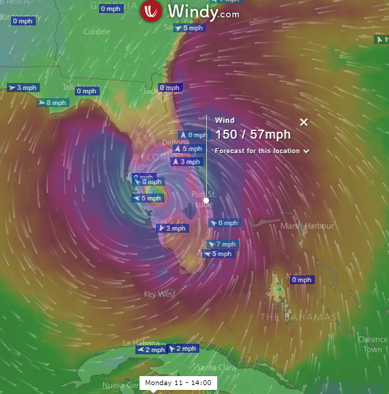 |
| Position of Irma on Monday at 2 PM if the ECMWF model is correct. Source: Windy.com. |
Perhaps the most highly regarded model seems to be the European model. That is shown in the second image, which shows Irma over by Tampa on Monday.
These two models are now a little closer than they have been at other times in the past couple of days, Unfortunately, both of them are very close to us.
One model has the hurricane moving more quickly than the other. GFS has it near us on Sunday, while the ECMWF shows the center nearest to us several hours later.
The models are still wiggling around quite a bit. The next time I look, the results might be very different. And there are other models showing different tracks. It is really hard to tell at this point where it might go.
 |
| Source: nhc.noaa.gov |
After the 5 AM advisory, they changed the nhc track to go up the middle of the state. It looks like they are splitting the difference between the European and American models.
 |
| New Irma NHC Track After 5 AM Advisory. |
After the 8 AM Update, I looked at the GFS and European model and both are now to the east of the Treasure Coast, but the European model is a little closer to the coast than the GFS. After the 8 AM update, those two models seem to be converging.
 |
| Source: wunderground.com |
---
11 AM NHC Advisory
The Irma track posted on the NHC web site after the 11 AM advisory is very much like the UKMET model that that you can see in the picture . NHC now shows a track moving along the east coast of Florida and very much over the Treasure Coast (below).
 |
| Source: nhc.noaa.gov |
I hope the eastward trend continues. I don't want to see the eye-wall going right over us.
Be safe,
TreasureGuide@comcast.net