Showing posts with label moving sand. Show all posts

Wednesday, September 27, 2017

9/27/17 Report - Lost Gold Ring. Jupiter Beach to Cocoa Beach. Shoreline Changes, Obstacles, and Special Opportunities.


Wtitten by the TreasureGuide for the exclusive use of treasurebeachesreport.blogspot.com.

Jupiter Inlet Beach.
Photo by Joe D.
Joe D. sent me these photos along with the following message.   

After just reading today's post, we have similar conditions here! In fact the beach has added 2-4 feet in places! Same problem; tons of seaweed and a mushy beach all the way up to eroded dunes! Waves from the east and little wind, even though it's large surf! All targets were light aluminum trash!
Some of pics are near same spots as I sent a few weeks ago so you can see the addition of sand
Looks like it will take a few week to normalize!


Joe D.

Thanks for the great photos and report Joe.  It does indeed look very much like the Treasure Coast.


Beach at Jupiter.
Photo by Joe D.
So what is it like just north of the Treasure Coast?  Dan C. sent the following.

... I have been hunting mainly Cocoa Beach due to its convenience -proximity to Orlando.
The post Irma hunting was good , meaning at least one gold find per 5-6 hour hunt.
The Post Maria hunting is not good.
You mentioned seaweed in your recent blog.
Actually, in the case of Cocoa Beach, it is about 80-90 percent Mangrove roots and branches, mixed with some seaweed.
Where did all these tree roots come from ? Indian River ? FL. Keys ? Bahamas ?
It would be kind of interesting to know where this stuff originated.
Or perhaps it is some variety of trees that grow in the dunes....... hard to tell as they are so pulverized, but the stumps are multi branched, the roots are short and fat.
There is enough of it to fill a dump truck for every 100 feet of beach.
It has formed clusters where it holds the sand, even in the wash zone- the waves don't break it up.
So, today hunted from 4 am to 930 to catch the low tide.
A few shell piles were formed close to the waters edge, produced nothing.
The shell line produced one stainless ring, one silver/enamel tiny pendant, one fake earring, a silver toe ring.
Higher up on the beach, I can see about a foot of new sand since last week, which came from Maria. I know it's at least a foot since it is full of those branches/roots even down deep.
Basically it's now all sanded in. Very little in the way of targets, even trash.
Perhaps if I can catch a flat day I will try a water hunt next.


Take care,
Dan in Orlando.


So these clumps of whatever are to be found at least from Jupiter to Cocoa. They were heavy on the Treasure Coast beaches today.  I also wondered where they came from.  Maybe we have a marine biologist or someone that can tell us.

On the Treasure Coast the biological materials, whatever they are, were catching sand and shells and in some cases being covered by sand.

One thing I should mention, and I haven't lately, is that when I talk about beach detecting conditions, I'm usually talking about finding shipwreck cobs and treasure coins.  I used to say that often and make it clear when I was giving a numerical beach conditions ratings.  At other times I might not always make that clear.

There is a correlation between beach conditions for finding old shipwreck items on the beach and finding more modern items, but the correlation isn't perfect.  Very old things surface less often than things that are just years or decades old..

Also when I give a rating or talk about beach conditions, I'm talking about general conditions.  I'm most often talking about those stretches of beach that produce shipwreck coins when the conditions are right.  You shouldn't forget, though, that when overall conditions are not great, there can still be small nooks and crannies where there is a chance to find something very good.  Often those places are beside a sea wall, jetty, rocks or foundation or something that provides an obstacle and opens a small pocket.  You might want to look around for some of those nooks or crannies.

Historic Shoreline Changes Around Present Day Fort Pierce Inlet
Source: marine.usgs.gov/coastalchangehaardsportal/
Here is the color key that goes with that.


Dark blue indicates the shoreline in 2012, and dark orange indicates the shoreline in 1830.

First you'll notice that the inlet was not open in the early 1800s.  The orange and yellow lines indicating the shoreline goes right through the inlet.

One thing I want you to see is that the shoreline north of the inlet has been moving out while the shoreline south of the inlet has been moving west.  They have tried to stop the erosion to the south of the inlet in recent years by dumping new sand there every year. Obstacles, like the jetty, large or small, disrupt the flow of sand and create what I call special opportunities.

There are some important lessons you can get from this illustration.  One very general principle is that when sand accumulates in one place, it leaves another.  That seems very obvious, but a lot of people don't appreciate the importance of that.  When sand builds one place, always ask yourself where it is coming from.  It is good to find where the sand is coming from and check where the sand is leaving.

You might have noticed that I posted some old wood finds since Irma hit our area.  There was the sheave and some other pieces.  That tells you something if you think about it.  Why did that old wood suddenly show up after all that time?  It was uncovered.  Where?  It could be from the beach, but we have not seen much beach erosion, or it could have been uncovered in deeper water and floated in.  Again stating the obvious, wood floats and therefore can travel very quickly and far once it is uncovered.

There is a lot to think about.  I'll stop there for today.

---

I just wanted to add this as soon as I found out.  Someone just reported that they lost a gold Claddagh wedding band in the John Brooks or Frederick Douglass beach area. Please help get it returned.

Thanks much.

---

Happy hunting,
Treasureguide@comcast.net

Tuesday, July 21, 2015

7/21/15 Report - Something You Need To Know For Water Hunting. Treasure Coast Waterways Cleanup. Junkyard Car Museum.


Written by the TreasureGuide for the exclusive use of treasurebeachesreport.blogspot.com.


See link below for details.
I have been looking at lot of very extensive studies concerning the movement of beach sand.  Some involve institutions such as Woods Hole and the Department of Defense.  Some involve laying fields of state of the art sensors, both in the beach and out into the water.  Some of the studies cost hundreds of thousands of dollars and the reports are full of technical jargon and mathematical formulas.  Those studies are only concerned with the movement of sand.  While I am interested in the flow of sand, I am also interested in how other objects such as coins move, and those studies to not address that, although I can draw some conclusions about that from what they do find.  A lot of the studies found nothing much beyond what I've learned through personal observation, which pretty much amazes me.

If you use the following link and browse around that site, you'll be able to find some of those studies.

Here is a link to a nice animation of that site.   When you get to the site, click on the multimedia section to view the animation showing the moving sandbar.  You might want to repeat it a several times.

http://www.whoi.edu/main/topic/changing-shorelines-erosion

 (Animation by Jack Cook, Woods Hole Oceanographic Institution)

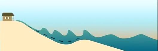
The location of sandbars can protect or endanger the face of the beach. As undertow drives sandbars away from the shoreline and further out to sea, waves break further from the shore. When sandbars are pushed closer to shore, waves break closer and run further up the beach. (From the Woods Hole site.)

I took some clips from the animation and added some things.  I added the two vertical lines so you could better estimate the position of the moving sand.  Orange dots illustrate coins.

In the first clip shown below, the sand bar is out and the currents are moving the sand in, but not the coins.  The arrows indicate the direction the sand is moving.


When the sand bar moves in, but the water velocity is not sufficient to move objects such as coins, the coins that were originally lost on the bar when it was out end up in deeper water (see below).  Objects lost in the dip in front of the sand bar (above) get buried, as shown below.


Compare the second picture to the first and note the relative position of the coins.  There are also times when the coins will move as well as the sand, but that isn't the situation illustrated here.  It is about trigger and drop points again.  Water force can be sufficient to move just sand or strong enough to move both sand and other objects.  Sand and coins can move at different times, and at the same time but at different speeds.

Sand bars are generally moving, sometimes very slowly.  As I've said before, items lost on the eroding side will be uncovered if they were previously covered, while items recently lost on the other side of the bar will get buried when the sand is moving in that direction.

Here are a couple more clips from the animation.  These show situations where the undertow moves the sand out.


When there is sufficient undertow, items as well as sand can be dragged out.  The clip below shows the bar moved out.  The bar has flattened some (below).  It could continue to move out until it looks very much like that shown in the first clip. When the velocity of the water drops the sand drops out of transport and piles up.


If you are aware of the sands position and how it is moving, that is a big step towards knowing where you'll find objects when you are metal detecting in shallow water.  Sometimes objects get uncovered and sometimes buried, and sometimes the objects are moved too.

Whichever way the sand is moving, objects are moving in some relation to that, again depending upon the trigger points and drop points of the sand and objects.

I hope the illustrations are clear and helpful.  I had a hard time getting them fixed the way I wanted, and still didn't get it exactly like I wanted.

----

The Treasure Coast waterway cleanup will take place July 25.  I hope you will support this.  Anyone can volunteer.  It would be a great thing for clubs.

Here is the link for all the information.

http://www.tcwaterwaycleanup.com/

---

 Nestled in a north Georgia forest, over 4,000 classic cars decorate 32 acres that have been turned into a junkyard museum. Owner Walter Dean Lewis' parents started the business in 1931 as a general store that also sold auto parts. Lewis grew the collection, which had just 40 cars in the '70s, over time...


Lewis stopped selling parts about six years ago, soon after realizing he could sustain the business more as a museum, charging $15 for visitors just looking, and $25 for photographers. He estimates that 95 percent of the people who come through the six miles of trails are photographers...
Here is the link for the rest of the story.  Sorta neat.
http://www.aol.com/article/2015/07/20/ap-photos-in-rural-georgia-a-junkyard-of-classic-cars/21211215/

--

I can't believe it.  That little two foot bump in the Treasure Coast surf predictions for next week has disappeared.  We're back to one foot for who knows how long.

Happy hunting.
TreasureGuide@comcast.net

Saturday, March 8, 2014

3/8/14 Report - Sand Movement and Obtacles, Speed Limit in 1861, Class Ring, Expensive US Coins.


Written by the TreasureGuide for the exclusive use of treasurebeachesreport.blogspot.com.

Sand bar created by obstruction near shore.

I'm still having trouble uploading videos to blog posts.  I had one for today but ended up making a series of stills out of it to illustrate my point.

In this first picture the shore line runs left (north) to right (south), pretty much along the bottom of the photo,and the log sticks out from the shoreline in something like a 45 degree angle.  Most groins, which I talked about back a few posts, would stick out at about 90 degrees, of course,  Nonetheless the principles are basically the same.

In this illustration the waves have been hitting from the upper left corner in about the direction of the arrow.

The water was coming up onto the newly created sand bar that you see to the left of the log.

Notice the lack of sand to the right of the log.  That is what you would see happen as the result of long shore drift, which on the Treasure Coast is north to south.  Look at our inlets and jetties and you will see something very similar.

Picture two showing direction of water.

Picture two (above) shows the direction of the water as it comes onto and up over the sand bar.

In the upper left corner you see a wave about to hit the sand bar.

The sand bar builds as the water washes sand in from the upper left,  The waves crash in front of the sand bar, suspending sand and moving it up the slope.  As the water slows down as it goes over the bar, the water loses speed and drops the sand.

Some of the water that makes it over the bar runs to the right and back down along beside the log.  However, as both this water and the water running back down the front of the slope goes out, there is another wave coming in which crashes into the receding water, thus stopping it from receding unabated.  That creates a brief zone of no current where some items are dropped for the moment.

If the size of the waves do not increase as the tide goes out, everything will happen closer to the top of the picture farther out in the water and the bar will be extended out into the water.

Picture three showing how there is little sand on the right side of the log.
Of course the waves are coming in from the same direction on both sides of the log  (from the top left of the picture).  However you can see that on the right side of the log, there is no sand build up.

The sand to the right of the log keeps moving to the right along the shore with the direction of the waves that are hitting at an angle.   There is no sand moving in to replace the sand that is moving out on that side of the log.

When you find a situation like this, no matter if the obstacle is a groin or a log or rocks or whatever, the place to hunt is on the side where the sand has been depleted.  That is where items that might have been dropped over time and accumulated could be uncovered.

If the wind changes and the waves change direction (then coming from the upper right hand corner)
the process would be reversed, though not completely because of the angle of the log, and the sand would build on the right side of the log and be removed from the left side.  Then you would want to hunt the left side.

Due to our north to south running near shore currents on the Treasure Coast (the opposite of the Jet Stream by the way) the predominant direction is for beach sand to travel north to south.  So when you have a significant sustained reversal you might get a good opportunity to hunt the north side of obstructions.  Watch for those unusual opportunities.

When the wind and waves are hitting from the south, it has to be large and sustained to have a significant impact for a variety of reasons.  One the wave energy coming from the south is moving against the near shore currents and the sand pushed in the direction in the past has to be moved before you get down to productive levels.

Swimmers often like to hang out on sand bars, so when a sand bar moves, that is a good place to be.

Recent Find Found by Using
Knowledge of Moving
Sand Bars
If you know about how forces like these work and you know your different beaches, you can intelligently decide what places you want to check before you leave home.

Sand bars are obstacles to the flow of sand too, as are holes, rocks, etc. etc.

Get to know your beaches and how they respond to different conditions.


Today I started a new experiment to show how objects of different size and weight sink in sand.  It is not a very refined experiment but in the first ten minutes I was seeing interesting results.  I'll report on that some time when the experiment is done.


Did you know that you could receive a fine for speeding in St. Augustine in 1861?

City of St Augustine vs Lewis slave of B Olivero; Fast riding through the Streets - January
26, 1861 (St. Augustine City Court Record)
On this day appeared Bartolo Oliveros owner of said slave Lewis in answer to complaint made by City
Marshal against said slave for riding through the Streets of said City on the 20 inst at a faster gait
than permitted by the City Ordinance.

The said Bartolo Oliveros owner of said slave having admitted the guilt of his said slave. His honor
ordered a fine of five dollars to be entered against said Bartolo Oliveros owner of said slave and that
said slave stand committed until said fine and cost be paid.


Here is the source link.   It has numerous interesting tid bits on Florida history.

http://www.drbronsontours.com/bronsonhistorypageamericanstaugustinecivilwar.html


The President's new budget gives the US Mint  the authority to do research on the composition of coins and authority to change the composition of coins.

The latest figures available from the United States Mint indicate a cost of 1.83 cents to produce and distribute each cent and a cost of 9.41 cents for each nickel. All other denominations cost less than their respective face values to produce and distribute.

The cost of making and distributing 5 pennies is about the same as one nickel.

Here is the link.

http://www.coinflation.com/coinage_material.html


We are having north winds and around a four or five foot surf this weekend.  It isn't enough to appreciably change detecting conditions on the Treasure Coast.  That is why I've been targeting modern finds lately.


Happy hunting,
TreasureGuide@comcast.net