Showing posts with label Frederick Douglas. Show all posts

Thursday, March 7, 2019

3/7/19 Report - Some Sand Moved By Yesterday's Front. Huge Historic Hoards. Big Artifact Database.


Written by the TreasureGuide for the exclusive use of treasurebeachesreport.blogspot.com.

John Brooks Beach Today Near Low Tide.

I didn't get out to look at the beaches yesterday, but I did today.

The cold front moved a little sand.  At John Brooks there was a little erosion in front of the old bigger cut.

John Brooks Beach Thursday Near Low Tide.
There were a couple detectorists at John Brooks today.

There were lots of people down by the water in Fort Pierce.  It was an absolutely beautiful day.

Another View of John Brooks Beach Today.

Frederick Douglas Beach Thursday Near Low Tide.

The sand was not firm until you got close to the water line.

Frederick Douglas Beach Near Low Tide Thursday.
There was one detectorist in south of Frederick Douglas.

Fort Pierce South Jetty Beach Thursday Near Low Tide.

There were no parking spaces at Fort Pierce South Jetty.  The snow birds are in town.

They also had some heavy equipment and large rocks at the nest entrance to the south.  I don't know what they are getting ready to do now.

I didn't get to any other beaches so have no idea what the cold front did to any of those beaches.

---
Location of One Hoard Discovery.
Source: See the GovMint.com link below.
I found an article on the GovMint.com web site that summarizes seventeen hoards that were discovered from around the mid nineteenth century up until near the present.  These are large hoards and are probably not representative of the average hoard, if there is such a thing. Some of them are huge.  None of these hoards were discovered by a metal detector.  Most were discovered before metal detectors were used.

I went through the summaries and tried to see what I could learn from that.  The areticle doesn't provide a lot of detailed information, so it would require more research on each hoard to do a thorough study.

The hoards were large.  One consisted of six tons of bullion and 100,000 coins.  Another was 600,000 coins, and another was 100,000 coins.   One was wooden boxes full of coins.  Some were in kegs or bags.

Two were associated with railroad stations.  One of those was under a loading dock. One was in a specially constructed underground vault.  Two or three were in old bank vaults. Some were in basements.  One was dug up in a farm field.  The Saddle Ridge Hoard, as you know, was exposed by erosion.

You might want to visit the web site and do more research.

Here is the link.


---

I received this email from Scott S.

Not sure if you have seen this database on artifacts, but here you go. I use it sometimes to try to identify a mystery object or just to see other finds from our friends across the ocean. Takes a little time to go thru all they have but its pretty helpful. Just thinking you might enjoy.
https://finds.org.uk/database

This is a super database published by the Portable Antiquities Scheme.  I think I mentioned it some years ago and I thought I put it in my reference list, but I couldn't find it there, so I I just added it along with the manual for cataloging buttons that I mentioned a few days ago.

Thanks Scott!

---

It looks like we'll have a two or three foot surf for a few days.  The tides are moderate.

Happy hunting,
TreasureGuide@comcast.net

Tuesday, February 26, 2019

2/26/18 Report - Views of Some Treasure Coast Beaches. Underground Stone Vault Found in Nova Scotia.


Written by the TreasureGuide for the exclusive use of treasurebeachesreport.blogspot.com.

Turtle Trail Afternoon of 2/25/19.
I was in the Vero area for an appointment yesterday and found time to stop at Turtle Trail.  It was about 2 PM.   There were a two detectorists already there.  You can see one of them in the distance in the photo below.

Turtle Trail Afternoon of 2/25/19 
Farther south from the access there were some shallow scallops.  You can see that in the photo below.

Farther South of Turtle Trail.
I didn't get to select the time for my visit, but was glad to get there for a little while anyhow.

Dale J. took the following photos of Seagrape and Wabasso yesterday.

Wabasso Yesterday
Submitted by Dale J.

Seagrape Trail Yesterday.
Submitted by Dale J.


This morning, I visited a few beaches on South Hutchinson Island.  Below are shots of Blind Creek, Frederick Douglas, John Brooks, and Fort Pierce South Jetty, in that order.

Blind Creek Near Low Tide This Morning.

Frederick Douglas Beach This Morning Near Low Tide.

The South Hutchinson Island beaches that I saw all looked pretty much the same this morning.  There were no new cuts.  All the beaches had seaweed. sloping and soft down to the wet area.  There were also some Portuguese Man-O-War.

John Brooks Beach This Morning Near Low Tide.

Fort Pierce South Jetty Beach This Morning Near Low Tide.

One detectorist was working South Jetty this morning.  You can see him in the photo.

I didn't see any other detectorists this morning.

---

Mysterious underground vault discovered on grounds of N.S. legislature.

Archaeologist says the large chamber isn't mentioned in any records or maps.

Archaeologists expected the land surrounding Province House in downtown Halifax to be fertile ground for finding artifacts, but they never expected to uncover an underground stone vault roughly the size of a living room...


Here is that link.

https://www.cbc.ca/news/canada/nova-scotia/province-house-grounds-artefacts-archaeologists-dig-archaeology-1.5026834

I seldom look at the comments, but figured there would be some relating this to the Oak Island show - and there were, including one that pointed out that this is very close to where they went to look for a stone they wanted to find.

---

This morning I took out my detector for a little while.  I only found clad, but I was reminded how important it is to spend time with your detector.  My pinpointing and target ID skills were a little rusty.  That is also one disadvantage of using different detectors.  It always take me a little while to make the transition.  I don't have trouble using the second detector, but I'm not quite as sharp.  There are a lot of subtle differences between detectors that you might not even notice unless you really focus on it.

--

The surf is supposed to be around two to four feet today and a little less tomorrow.


Happy hunting,
TreasureGuide@comcast.net

Saturday, February 2, 2019

2/2/19 Report - More Metal Detecting Reports From Around the Treasure Coast.


Written by the TreasureGuide for the exclusive use of treasurebeacheserport.blogspot.com.

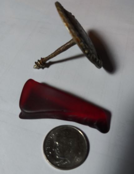
Antique Furniture/Upholstery Screw and Red Sea Glass Finds
Finds and photo by John L.
John L. was one of the guys that hit John Brooks beach early Thursday.  He then went down to Frederick Douglas, where he found these two items.

He is now most curious about the red glass.  After some research he found that it could possibly be hundreds of years old.

Same Treasure Coast Finds by John L.

He now believes the red sea glass is "gold ruby glass," which could be hundreds of years old.

He thinks the furniture screw could be a replica.  It does look in very good shape.

He found the following information relative to the red sea glass on the Corning Museum of Glass website.


"Gold ruby is arguably one of the most beautiful colors of glass. Beyond its aesthetic qualities, there is an alchemical connotation: Since ancient Greek times, descriptions of the sorcerers’ stone agree that it was believed to be a red substance and the key to the transmutation of metals, principally the making of gold (Ganzenmüller 1937;  idem 1956, pp. 85–128; Kerssenbrock-Krosigk 2001, p. 13). Whoever discovered how to color glass red must have thought himself to be on the right track to attaining the ultimate goal of alchemy. The 10th-century Persian physician and philosopher Rhazes (about 865–between 923 and 935) apparently believed that he had already fulfilled that objective. In his formula, the earliest known written account of a gold ruby glass, he stated that this glass attracted gold and silver like a magnet, and that it could convert 1,000 times its weight into gold. 1

About 800 years later, enthusiasm for gold ruby was at its peak. As far as can be determined from the legacy of princely treasures in today’s public collections, almost every central European sovereign seems to have owned one or more gold ruby glass vessels. This high point in the popularity of gold ruby glasses was confined to a relatively brief period: between about 1685 and 1705. It was preceded by a long history of developments that culminated in the production of large vessels that glow in a deep yet translucent ruby color. At its height, gold ruby glass was apparently considered to be not just another decorative folly but a genuinely new and precious material. It was ranked about as high as hard-paste porcelain, which came into production in Europe only a few decades later. During the 18th century, interest in gold ruby persisted in some regions and occasionally arose in others, but it never regained the widespread appreciation that it had engendered earlier.


The history of gold ruby has many beginnings. Red glass of some sort was produced almost from the time that glassmaking began. Knowledge was gained and then lost, and while there were rediscoveries on several occasions, this glass does not seem to have been produced again until it was revived in Brandenburg in the late 1670s and 1680s. It is here, with the arrival of the alchemist, pharmacist, and glassmaker Johann Kunckel (1637?–1703; Fig. 1) in early 1678, that the real story of gold ruby glass begins...

Interesting finds.  Thanks John!

---


Russ P. has done a lot of inland hunting, and found thousands of silver coins, was out to the beach this past week.  I've posted some of his research.

Here is what he had to report.


… I checked most of the known treasure beach access points from Sea Grape north, but only got my detector out at Bonsteel, with only a few trash finds. All the rest of the beaches seemed to have deteriorated from yesterday, in my opinion, with a lot of sand deposited at the base of cuts. Based on what I saw today, I don't think any of the cuts got close, at any point, to the size seen at John Brooks.

On the bright side, it was a beautiful day at the beach. I stopped at Melbourne Beach on the way home. It actually looked the most promising with a firm slope with black sand below a two foot cut. There were two other detectorists at the beach on my arrival. I have very little overall beach experience, but I found the coin line quickly. There weren't many coins, but it was stretched out over several hundred yards. There was no trash in the coin line. It was fun to put all the theoretical knowledge learned in this blog to good practical use. It really works!

Also, the Equinox 800 was superb. The coins were all six inches deep minimum, but gave strong signals. There was virtually no falsing, either in black sand or transition from dry/wet sand or vice versa. I picked up some very small pieces of fishing lures the size of earring backings. I was very impressed...


I've now heard from people from Juno to Melborne.  Various spots along the way eroded to some extent.  I haven't heard from Jupiter yet.

Although Russ hadn't done much beach hunting, he was able to apply what I've said about coins lines and quickly found one.

No matter if you walked away from the beach last week with a bunch of finds or not, you should walk away with some good new information.   Always be learning.

Depending upon how you define the Treasure Coast, it is around a hundred miles, more or less, long. That gives you over 5 million square yards of beach to scan.

Only a relatively small amount was actually detected, even if some beaches were hit by dozens of detectorists.  Many areas were just too far from the beach access for most people.  There are a lot of good spots that are far from the access.  Some of those will continue to hold good targets even after some of the other beaches fill in.

With the smaller surf, some areas (mostly higher on the beach) of the more productive areas will remain basically as they were a few days ago.  I know that there are coins just laying there still waiting to be detected.  I could get into that more some other time, but people tend to conclude it is all over just because the hottest of known spots have deteriorated.

We'll just have a two to four foot surf for a few days.

Happy hunting,
TreasureGuide@comcast.net


Thursday, January 31, 2019

1/31/19 Report - Detectorists Thoroughly Cover South Hutchinson Island Wreck Beaches Today Without Much Luck.


Written by the TreasureGuide for the exclusive use of treasurebeachesreport.blogspot.com.


First the important business: Sebastian Steve has some health issues and can use your prayers.

---

John Brooks Beach Wednesday.
Photo by Joe K.
I received these two photos from Joe K., who has been reading this blog regularly, but this is his first attempt at sharing photos.  He wondered how they came out.  My answer is excellent  They are better than the ones I posted.  He also provided the necessary info such as where and when.  It seems they were taken a little before the ones that I posted yesterday.  You can compare these with those and see what happened in a short amount of time.

There is a lot to look at in those two photos.  The bottom one is very dramatic.  

John Brooks Beach Wednesday.
Photo by Joe K.
And here is another photo from Wednesday.  It is of Pepper Park, and was submitted by Dale J., who has contributed several photos lately.

Pepper Park Wednesday.
Photo by Dale J.

That illustrates how different beaches vary.  Pepper is not nearly as cut as John Brooks.

Thanks much guys!


John Brooks beach was very thoroughly detected on Thursday, starting in the early morning hours.

John Brooks Early Thursday Morning.
Photo by Joe D.
Joe D. arrived at John Brooks this morning before sunrise and was soon joined by two other detectorists.

That beach already looks like it has deteriorated since yesterday.   Looks like I was overly optimistic about the level=-four beach conditions rating I issued yesterday.

Near 10AM Joe  sent me this message:  Only a penny so far, zero trash! Cleanest beach around, im sure! Used my silver wedding ring to test a few times just to make sure it was not me or detector error!! Six others besides me by 9:30! Interesting to watch the different equipment and techniques used, but not much digging by anyone!

John Brooks A Little Later.
Photo by Joe D.
I heard that twelve or fourteen detectors could be seen at John Brooks and Frederick Douglas once today.

At the end of the day Joe reported a few pieces of aluminum that were buried 4 to 9 inches deep.  He was using an AT Pro with a 8.5x11 DD coil.

I didn't get an reports from Vero and north today, so I don't know what was going on up there.

   ---

I don't know of anymore finds being made today on the Treasure Coast.  I haven't yet received the photos of the finds made earlier, and some people wait a while before reporting.

I any case, at this point I think I should have gone no higher than a level-3 beach conditions rating.  That is the way it seems now.  We'll have to wait to get a better idea of what all was found.

It looks like we'll have a two to four foot surf for the next several days.  At this time I'm not expecting any further improvement.

Thanks to everybody for all the reports.

Happy hunting,
TreasureGuide@comcast.net

Wednesday, January 30, 2019

1/30/19 Report - TreasureGuide Beach Detecting Conditions Rating for Treasure Coast Increased to Level Four. Finds Being Reported.


Written by the TreasureGuide for the exclusive use of treasurebeachesreport.blogspot.com.

John Brooks Beach Wednesday Afternoon.
Treasure Coast Beach Detecting Conditions rating increased again.  Yesterday I said the rating on the my beach detecting conditions rating scale was a three.  I'm now upgrading that conditions rating to a 4.  That is an increase from "good" to "very good."  The rating is for the Treasure Coast in general and will vary from beach to beach.

John Brooks Beach is cut deeper and farther back than it was a day or two ago.  I think you can see that if you compare this picture with the last picture I posted.

Some interesting small shell areas began to show up.  

There were finds that were already made.  I expect to receive photos before long.  But there will also be more finds being reported in the near future.  I'll start posting photos of finds as I'm able.


John Brooks Beach Looking South Wednesday Afternoon.

Notice the pallets just behind the cut.  A couple days ago, they were far back from the cut.


South of the Access At John Brooks.
The highest cuts are down by the bend.  Some great finds have come from that area in the past.


Frederick Douglas Beach Wednesday Afternoon.
The cuts at Frederick Douglas were not as big as those at John Brooks.

Thanks to the help of my friends who send in reports I've been able to keep up with things pretty well even while I've been under the weather and unable to detect for myself.

As I said, a number of finds have been reported already.  There were even a few made the prior week

Here is some info I got from Scott C., who has also been having some health problems.

...But, last week the winds were kicking up pretty good and on tuesday thru thursday especially on wed. switched to the S.E. and 25 steady...I know of a area that you know very well and it cuts with a SE wind. So Wed I was too sick to go but thursday I did make it there at low tide, there was a 3' -4' cut in that 50 yard stretch...found some Spanish but all musketballs, lead sheathing, small copper stuff...and a huge sand poured lead ingot, maybe 2.5lbs haven't weighed yet. It was fun just to get out and pretty much had the area to myself, 2 guys worked close by but left. Went back out Friday but it sanded in....

This week the winds blew again but this time took more sand away...I had to work most of the week so was only able to get out yesterday late and again with success with shipwreck stuff. But the difference this time was there were a lot of guys working the area. Stay tuned for photos hopefully of some of the finds.

Thanks much Scott!

I also heard from others who said they would send find photos.

When I looked out today and saw the strong north wind, I knew I had to go check the beaches even if I wasn't up to detecting.  I thought I had become very casual about metal detecting, but this experience has been extremely frustrating and aggravating.  I've experienced years and decades of good health and good metal detecting, and this makes me appreciate it even more.

Excellent beach conditions can be few and far between, so it is hard to miss it when it happens.

It looks like the wind will be shifting before long and will take on a more southerly direction.  The surf will remain about the same, with not very big tides.

Keep watching as the find photos come it.

Happy hunting,
TreasureGuide@comcast.new

Wednesday, January 23, 2019

1/23/19 Report - Current Beach Conditions and Development.


Written by the TreasureGuide for the exclusive use of treasurebeachesreport.blogspot.com.

John Brooks Beach Tuesday Afternoon.

This is the kind of weather the snow birds come for, but it isn't exactly what detectorists hope for.

This worked about the same way as several other fronts that came through in recent months.  They're quick.  You get a north wind for a day or two and some small cuts, but then the wind shifts and it fails to develop any more.

As you can see, there were some cuts at John Brooks beach, but they were two feet at most.  The sand was mushy.

Detectorist at John Brooks Tuesday Afternoon.

This nice fellow was learning to use his new detector and quickly picked up a couple of coins in the small shell line.

The high tide didn't get as high on the beach as I expected.

Waves At John Brooks Yesterday Afternoon.

The waves were hitting the beach straight on when I was there.

Looking North From Frederick Douglas Beach.
The erosion at Frederick Douglas was less than that at John Brooks.  The sand was a little more firm though.

L
Looking South From Frederick Douglas Beach Tuesday Afternoon.

I then moved south a little to see how those beaches were doing.


Blind Creek Beach Tuesday Afternoon.
Blind Creek had been one of the better looking beaches in the area, but not today.  At least the wind kept the nudie birds covered.

Looking North from Blind Creek.


Blind Creek has become a busy beach.  Both nudist and tourist seem to like it.  Tuesday it didn't look much good at all.

I also looked at Fort Pierce South Jetty Park.  Evidently I forgot to take photos.  It didn't look half bad.  There were some fresh cuts, but they weren't as big as they sometimes are at that beach.

---

Wednesday the surf is expected to be around four to six feet.  The tides remain big, but the wind will be more southerly.  I'm not expecting much, but we'll see.

On my beach conditions rating scale I would consider this a two on my five point scale.  That means its transitional, but, like I said, I'm not expecting much more.

Happy hunting,
TreasureGuide@comcast.net


Saturday, May 5, 2018

5/5/18 Report - What The Beaches Are Doing. Comments On Getting Coins Graded.


Written by the TreasureGuide for the exclusive use of treasurebeachesreport.blogspot.com.

Blind Creek Beach Saturday Morning
There is a bit of a dip up to the north.  Not too long ago this beach was eroded way back to the dunes.

Same Photo As Above.
Here is the same photo, but the orange line shows where it was eroded to not too long ago.  The blue line shows a bit of a dip that remained as of Saturday morning.  A lot of sand has accumulated since it was eroded back to the dunes (orange line).

Walton Rocks Beach Saturday Morning.
Walton Rocks looked very much like Blind Creek.  Notice all the sea weed on both.

Frederick Douglas Beach Saturday Morning.
Frederick Douglas, as you might expect, looked very similar to John Brooks.

Surf At Frederick Douglas Beach Saturday Morning.

There were the remains of some small old cuts at Frederick Douglas and John Brooks, but they were nothing exciting.
Fort Pierce South Jetty Beach Saturday Morning.
The biggest fresh cuts that I saw this morning were at Fort Pierce South Jetty. The one above was near two feet high.

Sand Dredge Boat About To Enter Fort Pierce Inlet.
The sand renourishment project continues at Fort Pierce South Jetty beach.  

Overall, I didn't see anything very exciting.  I detected a few minutes at Fort Pierce South Jetty and picked up a deep coin line.

By the way, I've noticed that the term "coin line" is being used all the time now.  Can anyone tell me where that term appeared in a publication prior to 2008?  I don't think you'll find it before that.

The people that write the books these days read everything else they can find and then use it as their own without giving any kind of credit.

---

I watched a little of Bigfoot: The New Evidence, a new TV series, but gave up on it pretty quickly.  Its too much like Curse of Oak Island but I think Bigfoot might be found first. 

---

I asked about coin grading the other day and got this excellent email from Bill K.


Ive had some of my personal coins graded and now use PCGS exclusively. When grading services first got started it was primarily ANACS............but........PCGS now dominates the arena. Turn around time is reasonable and cost for high grade coins is almost a must. I learned this lesson many years ago when I went to a local coin shop and purchased a $10.00 Indian gold coin the dealer insisted was "uncirculated". But, when I got it back from the grading service it was graded MS 55. This was a lot less valuable that what I had paid for an uncirculated coin (MS 60 is considered uncirculated)

One nice thing is that a PCGS MS 65 listed for sale that is "slabbed" (in the plastic sealed case) is pretty much an MS 65 wherever you go. At that point it may get down to eye appeal.........for example a MS 65 1916 D Mercury dime may be a bright silver but some may be "toned" (have a blue on it) My good friend only collects toned coins where I would only get bright coins even though both would grade MS 65

Some people have returned PCGS coins back to PCGS and had them re certified and you will see the little green CACsticker affixed.

Bill

Thanks Bill!

---

I'm not expecting any big changes in beach conditions in the next few days.

Happy hunting,
TreasureGuide@comcast.net

Tuesday, March 27, 2018

3/27/18 Report - Very Nice Cuts Found On Some Treasure Coast Beaches. Seas and Winds To Remain High.


Written by the TreasureGuide for the exclusive use of treasurebeachesreport.blogspot.com.

Treasure Coast Beach Tuesday Morning.
I saw one stretch of the Treasure Coast that had some nice cuts this morning.  Unfortunately it wasn't one of the treasure beaches.  Nonetheless I was glad to see the cuts and did about an hour of detecting - my first this month. I've been eye-balling lately instead.

I checked both John Brooks and Frederick Douglass beaches first this morning.

John Brooks Beach Tuesday Morning. 


John Brooks Beach Tuesday Morning.

There were very small scallops at John Brooks and Frederick Douglass.  The water had been back about half way to the dunes.

In the second picture you can see a couple people in the distance.  They were both detecting.

John Brooks Beach Tuesday Morning.
Frederick Douglass was very much like John Brooks.

Walton Rocks was not cut.

Fort Pierce South Jetty Beach was cut way back.  They are about ready to start dumping new sand there.

There was one stretch about a mile long that had intermittent cuts.  The photo sat the top of the blog hows one.  The next \photo shows another.  The one shown below was about six feet high at the highest.

Six Foot Cut In The Distance.
The cuts were not close together.  I checked about four, that were distributed over about a mile.

There were other detectorists there when I arrived.  I found some coins and stuff, but nothing great.
I'll get them cleaned up and photographed and post them sometime.  I don't think there was anything really old.

I talked about how some beach trends are of a longer term.  This beach was one that cut back some weeks ago.  I haven't seen any good cuts on John Brooks or Frederick Douglass all year.  Maybe I missed them.

This is the most improvement in beach conditions I've seen for a while.  I haven't seen the Vero or Sebastian beaches, so I don't know what they are like and I can't give an overall beach conditions rating, but based upon what I did see, I'd give it a 2 on my five point scale.   One indicates poor and five indicates excellent beach conditions.

I wanted to alert you to the improvement in beach conditions even if it the improvement is minimal and only to be found at a few spots.

The surf is supposed to remain high for a couple of days, getting even a little higher than today.  Unfortunately the wind will be more from the east/southeast.

Yesterday's post was one of the all time best, in my opinion.   It represents a lot of work and is an exceptionally thorough study that shows how much is in the ground and how much will typically be missed.  As some people say, "A site is never totally worked out."  Well this is one case when it came very close to being worked out.Re

Happy hunting,
TreasureGuide@comcast.net

Sunday, March 4, 2018

3/4/18 Report - Around The Treasure Coast. Updated Sunday Afternoon. Higher Surf Beginning To Hit Treasure Coast.


Written by the TreasureGuide for the exclusive use of treasurebeachesreport.blogspot.com.

Looking South Towards McLarty Museum A Little After Noon Sunday.

I took a look at some beaches in the Vero/Sebastian area just after noon today.  I saw no erosion, however some beaches were closed and some I didn't get to look at because the parking lot was full.

Golden Sands was closed for beach renourishment.  Turtle Trail was closed or repaving.  That is what it said anyhow.  It seems Turtle Trail is closed anytime something might happen.

The Wabasso and Rio Mar parking lots were full and I didn't see either of those.

As you can see above, there was no erosion up north of McLarty.  I also went north to just before the bridge, and the beach there was the same.

Looking South From Ambersands Beach Access Sunday After Noon.

The fellow you see in the above photo was detecting, but there was no erosion in the Ambersands area.
Looking North From Ambersands Beach Access Just After Noon Sunday.
The photo below shows about a foot cut under and a little ways to the north of the Seagrape Trail access.  That was in renourishment sand.  Otherwise, no erosion there either.

Looking To The North From the Seagrape Trail Beach Access Just After Noon Sunday.
My photo of Seagrape wasn't much good, but Alberto S. came to the rescue and sent the one below.

Seagrape Looking North
Photo by Alberto S.

Alberto sent the following report and photo of Wabasso.

Pics of Seagrape looking north and Wabasso looking south. Either direction looked the same. Turtle Trail has been closed for repairs. Yesterday Seagrape had 3 small cuts north of the beach entry and today they were gone. 

Wabasso Beach
Photo by Alberto S.
Thanks Alberto! 


I didn't get up to Bonsteel.  Generally beach conditions were not very exciting.

Below are the photos I took yesterday afternoon of some of the South Hutchinson Island beaches.

So far, despite the bigger surf and high tides, the beaches aren't looking too good.  However, I was there before the highest surf of the day, and tomorrow the surf is supposed to be even bigger.

I'm discouraged by the direction of the swells.

Below is what I posted earlier today.

Looking South From John Brooks Saturday Afternoon.
I went out Saturday afternoon to take a look at some South Hutchinson Island beaches to see what it looked like prior to the peak surf that we're supposed to get.

Here are photos from John Brooks and Frederick Douglas beaches.  Those two beaches looked similar.  You can see some small but unimpressive cuts already.  The slope was suprisingly firm.  I didn't look at any beaches in the Vero and Sebastian areas yet.

Despite the many snowbirds, the only detectorist I saw was leaving the beach at Fort Pierce South Jetty Park.  Some of the equipment used for beach renourishment is already there.  I didn't get to take a look at that beach though. 

I also looked at Walton Rocks but didn't see any erosion or improvement there.


Looking North From John Brooks Saturday Afternoon.
I hope to get out today and add to this report later today.  I'd also appreciate others sending reports from around the Treasure Coast or other parts of Florida.

Looking North From Frederick Douglas Beach Saturday Afternoon.
Happy hunting,
TreasureGuide@comcast.net