Showing posts with label waves. Show all posts

Sunday, July 5, 2020

7/5/20 Report - Waves, Liquifaction and Sand Movement on The Beach. NHC Map Lighting Up. Access to Technology and Data.


Written by the TreasureGuide for the exclusive use of treasurebeachesreport.blogspot.com.

Wave Photo by Clark Little Photography
Source: clarklittlephotography.com.
Although it seems like coins and rings and things sink in the sand, they don't sink in undisturbed dry sand without some disturbance of the sand.  You can easily prove that for yourself.  Just take a bowl or container of sand and place a coin or ring on top of it.  You can come back days later and clearly see that the item did not sink.

When you say a object sinks in sand, that seems to me to imply gravity as the primary force, which is misleading because the sand has to move to allow the object to "sink."  Maybe to you that is not an important distinction, and I can accept that, but for me, I'd rather place more emphasis on what has to happen with the sand.  That is what we have to know more about in order to be able to explain how an object will sink at the beach.

Clark Little takes amazing photographs of waves, like the one shown above.  If you visit ClarkLittlePhotography.com you'll see many great photos.

The above photo, besides being beautiful, shows some very interesting things.  Notice the brown area that the person is standing in.  There is brown all around the person, and there is also a brown vertical column in front of the camera.

The brown around in front of the wave shows that a lot of sand has been suspended by the turbulence.  And the brown vertical column, shows how sand has been picked up into the wave.  It seems clear that a lot of sand is being moved in that photo.

We don't often see a wave that big on the Treasure Coast, but the same thing happens with smaller waves, though to a lesser extent.  On the Treasure Coast we don't get waves like that, but the waves we do get will do the same thing - move sand.  And sometimes the waves do get pretty big.

Here is another great photo by Clark Little.  Once again, you can see the sand being sucked up into the wave.


Photograph by Clark Little.
Source: ClarkLittlePhotography.com.

As I've said many times, different materials and objects require different amounts of water force to move.  With a waves shown in these photographs a lot more than sand could be moved.

Here is an interesting explanation from Wikipedia explaining how sand fleas bury themselves.

Emerita is adept at burrowing, and is capable of burying itself completely in 1.5 seconds. Unlike mud shrimp,  Emerita burrows tail-first into the sand, using the periopods to scrape the sand from underneath its body. During this action, the carapace is pressed into the sand as anchorage for the digging limbs.   The digging requires the sand to be fluidised by wave action, and Emerita must bury itself in the correct orientation before the wave has passed to be safe from predators.

As the tides changes, Emerita changes its position on the beach; most individuals stay in the zone of breaking waves. This may be detected by the physical characteristics of the sand. As the tide falls, the sand is allowed to settle; when Emerita detects this, it uses the temporary liquefaction from a breaking wave to emerge from its burrow, and is carried down the beach by the wave action. Longshore drift also drag Emerita laterally along a beach.

Crashing waves cause liquification of the sand.  It burrows into the liquified sand, which settles when the tide recedes.

When you are talking about objects sinking into the sand, a number of things are going on.  Like I said above, it requires some disturbance of the sand.  In some cases that disturbance might be little more than sand moving away, while the denser objects remain.  When the sand is liquified, denser objects can actually sink into the sand, but that requires special conditions.  It does not happen unless the sand is being disturbed in one way or another.

In the near future, I plan to discuss some of the other variables and forces pertaining to how objects sink or appear to sink into sand.

---

Neural networks and AI could be a lot of help to the treasure hunter, but it would require a lot of research and development work, and access to the technology and data. For me the most valuable thing about going through years of higher education was access to technologies, labs and data.  I could  have done without the classes and lectures.  In fact, the thing in education that probably changed my life the most was discovering computers in 1969.

I started with batch processing, which involved punching computer instructions on punch cards, which were then submitted to the computer center.  You'd go back to the computer center in a day or two to get the output (you think your computer is slow).  As often as not, what you got was a listing of the many errors in your program that had to be identified and corrected before submitting the program again and waiting another day for the output.

I'll never forget the day I discovered a teletype machine that allowed me to use interactive BASIC to enter programs.  You'd hit a key and wait about two seconds before seeing the character typed on the computer paper on the teletype in front of you.  The delay in response took some getting used to but it was miles ahead of batch processing.  You know the rest - personal computers and then the internet.

If the general population had access to the most advanced technologies and data, progress would be accelerated many times.  If people had access to the raw data and information, there would be all kinds of genius geeks looking at the data.

A lot of things are accomplished by amateurs despite the barriers.  That is very true with archaeology.  Professionals have their own domain to protect and they seldom appreciate the talent that is sitting out there in the world.  Did you ever get a job when you were way beyond the person that would be your boss?  It won't happen.

In a very rare event about a week ago, a reporter actually asked a follow up question of Dr. Fauci, that elicited some useful information.  Dr. Fauci had mentioned in a very general way that something wasn't working, and the reporter asked what that was. Whoooaa - a reporter actually doing their job. Dr. Fauci said that contact tracing wasn't working because certain populations weren't responding to the calls.  In a moment of unguarded candor, he described those populations, but I won't.   I knew that very useful information was too politically incorrect to ever be mentioned in public again.  It wasn't.

Do you realize that a lot of the people at the top of the health agencies have been there longer than Moses wandered the wilderness?

The point I'm making is that the public only gets filtered information at best.  I'd love to see more good data put out there for the public to access.  Just yesterday I noticed a TCPalm headline that said something like 80% of corona cases are from minority populations.  I found some demographic breakdowns on the Florida Dept. of Health site and their numbers suggested nothing like that headline.

I don't do Facebook or Twitter.  I'm not much interested in the party line, the slogans, mantras, talking points or retweeted retweets.

I do very much like the idea of using neural networks and AI for contact tracing, but am personally more interested in tracing ideas and treasures than viruses, although that would be fun too if the data collection was more systematic and well defined.

---

Source: nhc.noaa.gov

Seems like the National Hurricane Center map is becoming a little more active.  Maybe we'll get some nice waves someday before long.

Tropical wave five is moving away from us and there is another area that has a small chance of developing in the next couple of days.

Happy hunting,
TreasureGuide@comcast.net

Wednesday, April 17, 2019

4/17/19 Report - Seeing Beaches, Cuts, Bars and Dips Form. Reflections on Cathedral of Notre Dame.


Written by the TreasureGuide for the exclusive use of treasurebeachesreport.blogspot.com.


I have an free Easter present for you today.  It is a little early. and it wasn't what I planned on doing, but it is just too good.

I'm going to show you an excellent wave tank video.  It begins with small slow waves and increases the frequency of the waves and then the size of the waves. You will get a really good look at how waves of different frequencies and sizes affect a beach differently.

There are some things I want you to watch carefully, so I'll give you advance warning.

Here is a clip that comes from the beginning of the video when the waves are small and the time between them is relatively large.


Small Infrequent Waves Building a Beach.

Notice how the sand is agitated in the high energy area where the wave is breaking.  I've mentioned this before, but this is the best illustration that I've seen.  You can really see the sand being suspended.  The suspended sand is then dropped on the beach as the water slows on the slope.

Suspended Sand Under Front of Wave.

You can really see how the sand is suspended in this clip  That sand moves back and forth as the wave passes, almost seeming to vibrate.  If you watch it in the video, you can see how similar it looks to the liquefaction video that I posted yesterday.  You can really see the similarity when the waves are more frequent.

While there is a lot of sand movement both ways in that area, there is a net movement either landward or seaward, depending upon the size and frequency of the waves.

When the frequency is increased,, you'll see the sand start to erode.  A small cut is created when the waves are frequent but not large.

Then when the waves get bigger, the whole thing accelerates, and a lot of sand migrates down the slope.

Bigger Waves Has Moved Sand Down The Slope And Has Created a Sandbar.

Notice also the dip.  That is an area that can expose a lot of objects on a beach, especially when the dip is down close to a hard rock or clay bottom.  That can be a real bonanza.

In the last clip, the sand has been completely removed from in front of the end of the tank.  That is how it would work if there was a sea wall or something behind a beach.  A sea wall will accelerate sand loss, as will a cut.

Now watch the video and you will see how all of those things develop.

https://www.youtube.com/watch?v=SCirBRjYKSo

If you watched the entire video carefully several times, you probably got a lot out of it.

I watched it quite a few times and will probably watch it several more times.

Again, a wave tank is not exactly like a beach, but you will find some things the same.

---

I wanted to comment on the Cathedral of Notre Dame.  We all saw the images.

Alain de Botton, author of the The Art of Travel said, “A dominant impulse on encountering beauty is to wish to hold on to it, to possess it and give it weight in one’s life. There is an urge to say, ‘I was here, I saw this and it mattered to me."

I lost the original reference, but I read the following in a current article. Maybe it was the New York Post, but I'm not sure.

… In a world that increasingly feels impermanent, transactional, brittle and under threat, the stillness and solidity of an 850-year-old steeple stretching into the sky gave us hope that some things remain. That how we once were is how we will always be.

Indulgently, these monuments are also a backdrop to our younger, more adventurous selves. They remind us of who we were when we fell in love or explored with friends or opened ourselves to long unscheduled weeks in unfamiliar lands.

You cannot gaze at a shimmering stained-glass window or find yourself dwarfed by a sepia-toned fresco and not feel sharper, rawer, as if in glimpsing beauty it is indelibly etched on your soul.

I think that is all pretty true, but watching it burn and crumble, reminds us that all things in this world, the most wondrous and long-lasting, will eventually crumble and fall.  In that we recognize our own mortality. And in the thought of rebuilding, we share the joy of resurrection Sunday.

Happy Easter!
TreasureGuide@comcast.net

Friday, March 29, 2019

3/29/19 Report - Beach Conditions and Cuts On The Treasure Coast. A Few Finds. Decreasing Surf.


Written by the TreasureGuide for the exclusive use of treasurebeachesreport.blogspot.com.

Treasure Coast Beach Cut Friday Morning.
Yesterday I struck out.  I spent more time driving than detecting and dug practically nothing.  This morning was different.  I enjoyed myself and made some interesting observations.

There was a number of targets down close to the water line at low tide.  Many were just discolored clad coins, some sinkers and fishing equipment, but also a few more interesting pieces.

The cut shown above was not close to any of the beach accesses.  I had to walk a way to find it. 

John Brooks Beach Friday Morning.
Like everywhere today, the water had been up and way over the berm.  You can see how mush the slope was if you look at the depth of the tire tracks.
John Brooks Beach This Morning.


Frederick Douglas Beach Looked very much like John Brooks.  You can see from the picture below how far back the water had been.


Frederick Douglass Beach Friday Morning.

Water Running Over Sand Bar and Back Out.
I started to put together a post on how sand and objects move on a beach, including some things that I've recently learned to better understand, and I saw a very interesting thing happening in the shallow water today.  I tried several times to capture it on video, but manage to capture it.

There is a sand hump in front of the beach.  At low tide there is a little trough in the swash zone.  The water would come in, and then as it ran back out, made a nicely formed wave reaching at least a foot in height that would collide with the water coming in over the hump.  The collision of the incoming and outgoing wave was pretty good.  I really wish I was able to get it on video.

Iron Clump and Clad Quarters Found.

Besides the iron clump and clad coins, I also found a couple old flat buttons and a square nail, and a piece of a large bronze pin.


Flat Buttons and Square Nail.
I was enjoying today because I got to do what I call "pattern hunting" and could have easily hunted a couple more hours but I had other responsibilities to tend to so had to cut it short.

I think I might be able to make out the marks on the back of these buttons.

The surf will be decreasing for a few days.

Source: MagicSeaWeed.com.

Even though we had some good north winds, the swells were predominantly from the east.

Really wish I was able to catch the returning waves on video.

Happy hunting,
TreasureGuide@comcast.net


Friday, February 8, 2019

2/8/19 Report - Adding Another Variable. The Effect of Wave Period. Bigger Surf Sunday.


Written by the TreasureGuide for the exclusive use of treasurebeachesreport.blogspot.com.
Souce: See MagisSeaWeed link below.

As I said yesterday, my first blogging did not involve treasure hunting.  In fact what makes my approach to metal detecting a little different is my old school scientific approach.. My professional life began as an academic and researcher, and I approach most everything still today with the same empirical scientific attitude.  You won't find any scientist worth anything making wild claims without a lot of good data and logic to support his conclusions, or at least making it clear when he doesn't have much data.  By nature and training I am still very much a scientist at heart.

If you've been reading this blog very long, you know that I've spent a good deal of time talking about erosion and how items get distributed on a beach.  My conclusions are based upon both observation and experiment.  I've reported on some of my experiments in the past.  While I feel like I have a pretty good understanding of many of the processes involved, there are still some unknowns, especially having to do with what takes place in front of the beach during rough surf.  That is difficult to observe.

One of the things that I've pretty much neglected up to this point is the effect of the wave period.  I've been told before by an oceanographer who reads this blog when the topic is erosion, that wave period is important, but I haven't studied that or considered it in any serious way.  Fortunately I just discovered an article on the topic that I'm sure will help.

At the top of this post you'll see an illustration of a longer period wave and a shorter period wave.
It shows how a longer period wave will affect the bottom in deeper water than a wave that has a shorter period.

One way I've made use of the circular nature of the particles under the wave is by lifting my feet as a wave passes so that it drops me back in the same spot.  I've described that method of working rough water in the past.

A wave is also affected by the bottom.  It is the bottom that causes the wave to change shape and break.

Here is the beginning of the article I'm talking about.

Size matters – we all know that. But when we are talking about swell, the period matters almost just as much.

The last few big swells in the North Atlantic have arrived with periods of up to 19 or 20 secs, which is pretty long for this part of the world. The long periods gave the waves an extra punch at many places, and, at some spots, a lot more size than you would normally expect...


Here is the link if you want to read the entire article. 

https://magicseaweed.com/news/swell-period-what-is-it-and-why-does-it-matter/10930/

Even though somebody mentioned to me years ago about the importance of wave period relative to erosion, I didn't look into it much.  We always talk about the tides, surf height, and angles, but now I hope to be adding another factor.  This article gives some very helpful information, and I'm sure I will be able to fill in some of the gaps in my understanding as I study it more.

One important thing is where the waves break.  Often they break in front of the beach on a sand bar, just churning up sand and anything else that might be near the surface.  If you follow the surfers, I think they'll be hunting waves that are breaking out some.

I'm glad I found that article and will undoubtedly be revisiting the topic in the future as I add to my understanding.

---

Source: MagicSeaWeed.com

As you can see, the peak surf of up to seven feet is still predicted for Sunday.

It looks like the tides will be  moderate and the wind mostly southerly.  The wave period is going to be about 6 seconds.


Thanks for all the get-well wishes.  I'm better now.


Happy hunting,
TreasureGuide@comcast.net


Tuesday, January 8, 2019

1/8/19 Report - How Mammoths Were Killed by Man. Water Forces and How Objects Move on a Beach.


Written by the TreasureGuide for the exclusive use of treasurebeachesreport.blogspot.com.

A flint point was found in a mammoth bone that provides clues about how mammoths were killed.  Here is an excerpt from that report.

"Among tens of thousands of bones, during a detailed analysis of the remains, I came across a damaged mammoth rib. It turned out that a fragment of a flint arrowhead was stuck in it. This is the first such find from the Ice Age in Europe!" - told PAP Dr. Piotr Wojtal from the Institute of Systematics and Evolution of Animals PAS in Kraków. The analyses, co-financed with the National Science Centre grants, are conducted jointly with Dr. Jarosław Wilczyński.

Wojtal reminds that the scientific community has been discussing for years how our ancestors killed mammoths. According to some researchers, these animals were killed by trickery - chasing them to the pits or towards bluffs, from which they would fall. Others say that people focused on weaker or sick animals. Some think that mammoths were hunted...


Here is the link for more about that.

http://scienceinpoland.pap.pl/en/news/news%2C32358%2Ckrakow-first-evidence-europe-man-was-hunting-mammoths-discovered.html

---

On different occasions I've talked about how coins and items move on a beach and the forces that move them.  Today I'll address the complexity of the water forces.

There are many different water forces that act on an item on a beach.  First of all, the water doesn't hit the beach or an individual item from just one direction.  The most obvious example is the incoming and outgoing water after each wave.  The incoming water hits in one direction, and the outgoing water, if it gets there, from another direction.  But there will often be a primary and secondary swell too, and they will hit the beach from different angles.

Not only can the water come from almost any direction, but the amount of force will vary dramatically too. The amount of force can be nearly zero or very violent.  The force of a crashing wave can be great.  That is water crashing down.  A breaking wave can also, or a passing wave can also lift sand and other items.  I've shown pictures of that before.

Considering all that, an item can be hit from almost any direction and with greatly varying amount of force, but that is not all.  The force will also be different on different parts of a single object.

I once posted a link to a video showing an experiment in which a stream of water was directed up a sandy slope and over an object that was sitting on the slope in shallow water.  The amount of force was sufficient to move the sand on the front of the object, but not enough to push the object up the slope.  The result was that the object slipped down the sandy slope in steps.  When enough sand was moved from the down-slope side of the object, the object slipped down and settled again until enough sand was moved so the object slipped down again.  As the water flowed around the object, the sand on one side (the down-slope side) was moved away until gravity moved it down the slope.

I described that experiment in more detail in a March 2014 post.  Here is the illustration and brief description of the experiment.

Object On Sandy Slope and Stream or Current Directed Up Hill.


The current pushed the sand away from the front and sides of the object as the water rushed around it.  The object then STEPPED down the slope.  I say "stepped" because it moved in small quick steps, pausing in between steps.

The current moved the sand from the front of the object but not the back of the object.  Gravity on the object and also the sand behind the object then moved the object down the slope.

The current trigger or threshold level was sufficient to move the sand in the current up the slope but gravity moved the object down the slope.


Here is the link to that post, which also described another related experiment.

https://treasurebeachesreport.blogspot.com/2014/03/31014-report-experiments-on-movement-of.html


It might seem surprising that the object actually moved opposite the current, but that is the way it worked out.

If this was a wave, instead of a steady stream, you'd also have returning water too instead of water running in one direction, and that could move sand down the hill faster than the object moved down the hill.  And that could bury the object.

You have vastly different amounts of force at different times and locations.  The amount of force of a crashing wave can throw objects and suspend a lot of sand.

I think you can see how complex this is with the water moving  in a variety of different directions and with varying amounts of force.

How an object moves on a beach depends on how the water moves the sand in relation to other objects.  Different objects require different amounts of force to be moved.  The sand moves easier and faster and uncovers or covers objects that move at a different rate.

I've discussed that before along with the subject of thresholds and trigger rates.

---

Not much surf this week.

Predicted Surf.
Source: MagicSeaWeed.com
Happy hunting,
TreasureGuide@comcast.net

Saturday, November 24, 2018

11/24/18 Report - What's Going On At the Beach.


Written by the TreasureGuide for the exclusive use of treasurebeachesreport.blogspot.com.

John Brooks Saturday Morning.
Yesterday I showed this same view.  Since then the surf came up over the berm and smoothed out the cuts.  We've had some really high tides lately, and today the wind was from the west.

The waves were rather impressive.  They were crashing right in front of the beach.

Surf At John Brooks This Morning.
There were a lot of surfers down at Blind Beach where the swells were building farther out.

Frederick Douglass Beach Saturday Morning.
Frederick Douglass Beach was smoother today too.

Lady Detecting the Seaweed Line At Frederick Douglass This Morning.
You can see where the water was.

Setting Up For a Beach Wedding At Frederick Douglass Saturday Morning.
Besides the wedding setup, you can see the horses coming in.  A lot people were out enjoying the beautiful weather on a holiday weekend.

Riders Returning at Frederick Douglass
Down at Blind Creek there were a lot of people, including surfers, but no erosion.  I did notice one of the old dead trees was moved by the water.

Fort Pierce South Jetty Beach Saturday Morning.
Notice the water behind the new sand to the north in this photo.

Now I'll show you Fort Pierce South Jetty as it looked yesterday. 

Fort Pierce South Jetty Beach Friday Morning.
What a difference a day makes.  The cuts are now gone and a lot of new sand has filled in.  That is a good comparison.

I haven't been farther north, so don't know what is going on in the Vero or Sebastian area.  Maybe someone will let us know.

If you can find a place where the water was up in the natural dunes, it might be good to check it out.  I saw one place where that happened, but it was really minimal.

The west winds will be continuing until Tuesday, and the surf will be decreasing over the next few days.  The tides are still nice and high though.

Happy hunting,
TreasureGuide@comcast.net


Thursday, September 6, 2018

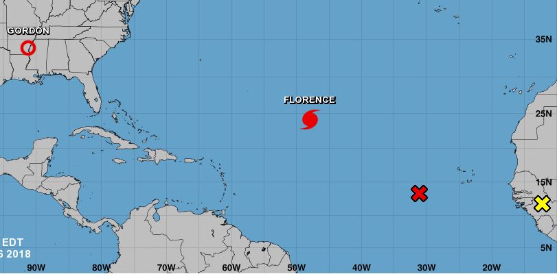
9/6/18 Report - Big Surf Predicted for Next Week. Florence Could Cause Problems For the U. S. Coast.


Written by the TreasureGuide for the exclusive use of treasurebeachesreport.blogspot.com.


Three More Systems To Watch.
Source: nhc.noaa.gov
After a very quiet summer, there is now a lot of weather in the Atlantic.  

The most significant thing to watch right now in my opinion is Florence, which has been wobbling.  For a while she was headed west towards the Bahamas.  

The system behind Florence has a 70% chance of becoming a cyclone in the next forty-eight hours.  And then there is another area behind that one to keep an eye on.

It now looks like we could get some big waves next week.


Three to five feet is predicted for this weekend, with seven to eleven feet for next Wednesday.  That could get interesting.  We haven't had waves like that for quite a while.  There is a lot of sand to be moved, but that could do it.


Florence Off the East Coast Next Wednesday.
Source: Ventusky.com
If you are wondering what would cause the high surf, here is how Ventusky shows Florence next Saturday - well north of us, but sending waves our direction.

Notice the other system below that.  There is a lot going on there.

That system is predicted to be near the Dominican Republic the following weekend.

Prediction for Ten Days From Now.
Source: Ventusky.com
Of course, this is just a prediction, so it might not happen.  But it is worth watching.  We might get some improved beach hunting in the next week or two.

---

I typed a few paragraphs paragraphs how objects moved on the beach, but lost it somehow.  I'll have to rewrite that to post some time in the near future.


One of Japan’s busiest airports remained closed indefinitely, a day after the strongest typhoon to hit Japan in 25 years flooded a runway, toppled huge cranes, flipped cars on their side, damaged historic shrines and caused at least 11 deaths as it swept across part of Japan’s main island.

Typhoon Jebi came ashore with sustained winds of 160 kilometers (100 miles) per hour, cutting a path of destruction in and around Osaka and nearby cities that bore the brunt of the storm...


Here is the link for the rest of that article.
https://apnews.com/24053a149be740e2aeb73957fb751bc1/Typhoon-leaves-major-airport-closed-and-destruction-in-Japan

---

In recent months, two 150-ton survival bunkers journeyed by land and sea from a Texas warehouse to the shores of New Zealand, where they’re buried 11 feet underground.

Seven Silicon Valley entrepreneurs have purchased bunkers from Rising S Co. and planted them in New Zealand in the past two years, said Gary Lynch, the manufacturer’s general manager. At the first sign of an apocalypse — nuclear war, a killer germ, a French Revolution-style uprising targeting the 1 percent — the Californians plan to hop on a private jet and hunker down, he said...

Here is that link.

https://www.bloomberg.com/features/2018-rich-new-zealand-doomsday-preppers/

Looks like all the super-rich are ready to take off and leave us poor suckers behind.


Happy hunting,
TreasureGuide@comcast.net

Thursday, May 31, 2018

5/31/18 Report - Illustration Showing How Sand is Moved. Deadly Lightning.


Written by the TreasureGuide for the exclusive use of treasurebeachesreport.blogspot.com.

Shallow Water Sand Spit
As you probably know, I spend a lot of time talking about how sand and other items move on a beach and in the shallow water.  That is critical information for any detectorist who wants to understand what is going on and where coins and things will most likely be found.  Today I'm going to try to show a developing sand spit.

In the above photo, there is a sand spit that runs from the bottom right of the photo to near the top center of the photo.  I'll outline that below.

Also there was water hitting the spit from two directions.  I'll also try to highlight that.


The predominant direction of the waves is illustrated by the blue line labeled A.  In deeper water that was the direction (from the upper right corner towards the center of the picture ) of all the wind driven waves.  As you can see things were different in the shallow water.

Near the orange circle, labeled D, there seemed to be a point where the waves bent and came up onto the sand bar as shown by C.  I watched this a little earlier before the bar was covered by water and waves were coming from about two o'clock and there were also waves hitting the bar from about 10 o'clock.  I wish I had my camera at that time.

The orange spot (D) would be the first place I'd check with a metal detector, however the dip was not nearly deep enough at this time.

The waves coming onto the bar from the left were getting bent and breaking on the sand spit.  You could see how the spit was bending the waves coming from that direction.

The following illustration shows waves hitting the spit from both the right and left.

Yellow Lines Indicate Waves Coming From Left
and Orange Lines Indicate Waves Coming From Right.
I came back the next morning and, as you would expect, the spit had changed a little.  The tide was lower and you could see more of the sand.  It had changed a little, but you can still see the waves wrapping around the point.


The water was funneling through the low spot and then encountering the slope, and having no where to go, piled up on the slope and the spit.  The waves appear to slow wherever it is shallower.  That causes the waves to bend.  There was undoubtedly also some water bouncing off the hump of sand at the upper left and bouncing back towards the spit.

Layers of Sand Built Up On Left Side of Spit.
Pshewww!  I finally got that done.  I spent a lot of time trying to upload a video but never got it to work.

---

A Lake Worth woman was killed by lightning.

https://www.mypalmbeachpost.com/weather/lake-worth-woman-killed-lightning-strike-parkland-injured/Chbg6q5PcbM71opQGjpF6I/

---

I spent a lot of time on the illustration above.  I'll get back to some other things I had planned in then near future.

Check out the TGBottleBarn.blogspot.com.

I'll keep adding Treasure Coast bottles as I get a chance.

---

On the Treasure Coast have a one foot surf for a few days.  That makes for easy shallow water hunting.

Happy hunting,
TreasureGuide@comcast.net

Sunday, May 27, 2018

5/27/18 Report - 18 Foot Waves From Alberto For Parts of FL. Whatzit Coin Solution. Double Die Coin Error Site.


Written by the TreasureGuide for the exclusive use of treasurebeachesreport.blogspot.com.

Alberto
Source: nhc.noaa.gov
On this rainy holiday weekend, Alberto is still heading towards the Florida Panhandle and tropical storm warnings are out for much of Florida's west coast as well as the panhandle.

The NWS said waves as high as 18 feet (5.5 meters) could pound the popular Gulf beaches in Baldwin County, Alabama, and northwestern Florida on Monday. A high surf warning was in effect through 7 p.m. Tuesday local time.

At 5 a.m. EDT Sunday, the National Hurricane Center in Miami said Alberto was about 330 miles (530 kilometers) south of Apalachicola, Florida, and moving north-northeast at 13 mph (20 kph). The storm had top sustained winds of 40 mph (65 kph)...

Here is that link.


Alberto is predicted to be very near landfall on Monday morning.

Source; Ventusky.com
Here is the Ventusky prediction obtained at around 7AM Sunday morning.  It looks like nothing more than 50 mph sustained winds.  The water will be building up in the big bend area.

On the Treasure Coast the surf is supposed to be three to four feet today (Sunday) decreasing tomorrow.

--

First off I want to say thanks to each and every person that sent their ideas on the mangled coin that I posted yesterday.  Every response is important to me.  I don't care if everyone has the same answer or if there are different opinions.  Each response makes a difference to me, and I appreciate those of you who take the time to respond.

If I get several responses that are all the same, that gives me a lot of confidence in the answer.   If there are divergent opinions, that is important to me too.  I do very much appreciate and consider every response, and every response means a lot to me.

In this case, there was a very high degree of agreement, and I am now highly confident that I have the answer.

There was one thing that really threw me off.  I'll show you what it was.

Below is a picture showing what I originally misinterpreted.


One Side of the Mangled Coin That I Posted Yesterday.

In the above photo, the red lines show the area that I mistakenly thought was the bow of a boat.  What I thought was the front of the bow was actually part of the outline of the state of Minnesota.  The boat that actually appears on the coin lies within the yellow circle.  So I was right that there was a boat on the coin, but I was wrong about the placement.  When I tried to find a coin that had a boat where I thought I saw one, I didn't find one that matched.

Here Is What The Coin Looked Like Before It Was Mangled.

Once again, thanks to all who responded and helped me figure his out.

---

Here is a great web site for checking out possible double die error coins.

http://doubleddie.com/

---

Happy hunting,
TreasureGuide@comcast.net


Thursday, December 7, 2017

12/7/17 Report - Sebastian Fisher Treasure Museum Admission Free Sunday. Analyzing Cut Marks. Coastline Angles.


Written by the TreasureGuide for the exclusive use of treasurebeachesreport.blogspot.com


I just received an email announcing the open house yesterday.  Admission free Sunday.

---

John C. sent his thanks for helping to identify his USMC ring and wanted to especially thank Sherry, who came up with the answer.

He sent the following picture and said, Here is What happens with discarded fishing line ,This turtle washed up at wabasso beach in 2010 ,It looks like heavy test 80 or a 100 pound ,I think it's from long liners, But I'm not sure .

Turtle On Wabasso Beach Back A Few Years Ago
Photo by John C.
I just happened to see a TED talk where they showed small pieces of plastic in a fishes gut.

---

You probably know about Vero Man and what that is all about.  It all started when a local collector noticed carvings on an old fossilized bone.  I've found what appears to be shark bite marks on Dugong and other bones, but just the other day I picked up a vert and later noticed what appears to be bite marks on it (See below.).  Of course that is nothing scientifically significant.  It was just interesting to me, and goes right along with an article I was going to post today anyhow.

Large Vert With Cut Marks.
By the way, if you can identify what this vert is from, let me know.

The International Business Times reports that scientists have developed a method to analyze the marks on animal bones recovered from archaeological sites. The shallow marks left by stone tools are often “V” shaped, while those made by trampling animal hooves are usually “U” shaped. The new technique, which employs 3-D imaging, shape analysis, and Bayesian statistics, was shown to identify butchery marks made by volunteers with stone tools 88 percent of the time.

Here is the link.


http://www.ibtimes.com/how-smart-were-prehistoric-humans-their-knives-tell-scientists-lot-2624672

---

Source: Google Maps

I was talking to somebody about beach and wave angles.  I often talk about the beach like it runs north/south, which is seldom the case.  As you can see from the map above, the Treasure Coast runs more to the northwest, while south of Palm Beach it is more north/south.

On the Treasure Coast it takes more of a northerly direction to get that slicing action that causes erosion.  If it is just a little to the north, it will actually be hitting most of the beaches pretty straight on.

Of course the coastline is not straight and there are many curves or bends.  That means that the waves will be hitting at a different angle as you go around a bend.  Before you get to the bend you might see accretion, but when you get around the bend you might see erosion.  The angles change.

Beautiful day.

I'm planning some experiments that will demonstrate some important things, but I don't know if I'll get it done by tomorrow.

Happy hunting,
TreasureGuide@comcast.net


Tuesday, September 26, 2017

9/26/17 Report - What the High Water Did To Some Beaches. Useful Web Site For Predicting Beach Conditions. Various Types of Finds Along the Treasure Coast.


Written by the TreasureGuide for the exclusive use of treasurebeachesreport.blogspot.com.


Frederick Douglas Beach This Morning.

Yesterday I showed the water getting high on Frederick Douglas beach.  Today I went out to see what happened.  The answer unfortunately, is very little.

I'm about to call Irma, Jose and Maria all a bust when it comes to improving metal detecting conditions.  Who would guess that three hurricanes would not produce much better beaches?  Not one of them did a lot for us.

There are reasons.  And I'm always learning.  I learned something just the other day.  Actually I already knew it to some extent, but didn't give pay take it into account enough.  There is little use to pay attention to wind direction unless it is blowing fairly hard.  Otherwise it is not going to affect the direction of the swells.

The past few days I looked at the wind direction on MagicSeaWeed, but I didn't pay enough attention to the wind speed.  I should have paid more attention to what web sites like Ventusky.com was telling me when I plotted the waves.

Below is an example.


Wave Direction.for Yesterday.
Source: Ventusky.com

What I saw at the beach yesterday and today matched what Ventusky.com said a couple of days ago (See my 9/23/17 post.). The waves, as predicted were hitting the beach straight on despite the north winds. The wind wasn't very strong, so didn't seem to have much effect.

We always talk about northeasters, but direction isn't the only factor.  The wind has to be fairly strong, otherwise they won't have a significant effect on the swells.

I think I could do this a hundred years and I would still continue to learn.

Below is another picture of a beach that I looked at this morning.


Treasure Coast Beach Tuesday Morning.

Notice the waves coming directly at the beach and all the seaweed.  The beach was building.  You could see new layers of sand on the beach.  That isn't what we were hoping for.  I'll pay more attention to the swells in the future and less to wind direction.  

I've said before that it doesn't take a hurricane and recently went over what happened during the Thanksgiving Storm of 1984.  Jon Morgan, who does the great Lets Talk Metal Detecting and Treasure Hunting podcasts, said that post was very helpful to him.  You might want to take a look at that post again.  Hurricanes don't always create good detecting conditions.  Neither does high water.

I made a few interesting finds today - at least I thought they were interesting.

I found one very big piece of wood.  It was about seven feet long.  My photo showing the entire length somehow got lost, but here are a couple photos of a section of the wood.


Large Piece of Wood Found On Beach This Morning.
 Notice the worm holes and the apparently worked surface.


Another Shot of the Same Piece of Wood.


Ballast Stone?

A couple of days ago I mentioned finding some pieces of fossilized bone.  Here is the smallest - a small vertebra.

Small Fossilized Vertebrae Shown On U. S. Nickel.

I picked up more fossils today.  They are shown below.

Fossils Found On Beach Today.

The most interesting one to me was the piece of antler.  I've found those before and always like them.

Here is a closer view of that one.

Fossilized Piece of Antler.
And here is an ever closer view that shows the nice color and texture.

Closeup of Fossil Antler.
I walked a long distance today because I wanted to check out a particular location that I have not seen for quite a while.  It wasn't much good for detecting, but I did pick up the fossils on the way.

As I often say, when conditions aren't good for finding one type of thing they might be good for finding other things.

Today I didn't do any detecting, but kept myself entertained with wood, stone, fossils and shells while I scouted a few beaches.

I'll be showing you some more things I learned tomorrow or some other time real soon.  I think that is all for today.

Happy hunting,
TreasureGuide@comcast.net