Written by the TreasureGuide for the exclusive use of treasurebeachesreport.blogspot.com.
 |
| John Brooks Beach February 22 Photo by Bill R. |
The above picture shows John Brooks beach as it looked on Feb. 22. I showed how it looked on Feb. 24 in my blog. This cut had disappeared by then. I think I visited the beach last Wednesday but didn't have my camera. I don't remember for sure if that was the day or not.
It looks like John Brooks beach eroded and then the cuts disappeared again twice in just the last week or two. The cuts quickly appeared and then disappeared again.
The sand that was removed to form the cut seems to be piling up directly in front of the beach where the beach extends out at least forty yards at low tide.
Thanks for the picture Bill.
---
I found a really informative dissertation. The title is The Archaeology of Shore Stranded Shipwrecks of Southern Brazil. It was written by Rodrigo de Oliveira Torres and dated 2015.
Shipwreck archaeology is usually conducted on shipwrecks in deep water. A few have been left high and dry, like the one in Namibia that I recently mentioned or some that were otherwise covered by like those in harbors that were filled. Shore stranded wrecks are in a very high energy zone and are difficult to study. They are usually broken up and scattered but parts occasionally surface from time to time. One example in the dissertation shows that not only do some disappear and reappear, but also that they move between appearances. That happens with large sections of hull as well as smaller pieces and individual artifacts.
Referring to the high energy zone and the lack of meaningful archaeological context in that zone, the dissertation says, It is assumed in these circumstances that cultural relatedness is too highly variable and does not correlate with spatial proximity, drastically affecting the coherence of the archaeological record. In other words, things get scattered in ways that make it impossible to study archaeologically. Continuing, they refer to several sources and say, By definition, an archaeological site is a place which contains, in a more or less preserved state, information about past events and activities embedded in artifacts and their spatial relationships.
Here is another relevant quote. French underwater pioneer Frederic Dumas is generally credited with the first contributions to the differentiation between depositional environments, by drawing a distinction between the differential preservation potential in sandy shores, rocky shores, and shores with cliffs (Dumas, 1962: 4-7): A flat coastline where the sand descends gently to depth is not promising. Scattered remains will be buried after the ship has been broken by storms and swell. Rocky shores are more likely to retain traces of shipwrecks: parts of the ship or its cargo are preserved in declivities. […] in shallow water the sea breaks everything and the dislocation of a wreck decreases its interest. […]
The beach profile illustration that I posted yesterday came from the same dissertation. Here it is again.

This refers to summer and winter profiles, but what I've been showing lately are not seasonal changes but daily changes that are very similar. Shorter term changes occur around the net seasonal changes, which in turn occur on top of longer term changes that might be trends lasting decades or centuries.
One thing that you might take away from this dissertation is that most of the principles that I talk about as they refer to the Treasure Coast are applicable to such distant and diverse places as Brasil. Many of the principles are universal and apply anywhere.
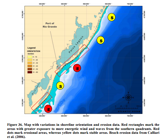
Here is a nice illustration from the Torres dissertation. If you look at the map, you'll notice that the erosional areas (red dots) are in areas where a south wind would hit most directly. The stable areas are less directly exposed to wind and waves from the south.
That is the same way it works on the Treasure Coast, except our erosional areas are those most directly esposed to wind and waves from the north.
You'll often find cuts at one area and then around the bend, either smaller cuts or sometimes accretion. Also one area will build sooner and quicker than another area just around a bend. It is very much about angles, and a relatively small change in angle can make a big difference.
I found the dissertation on https://oaktrust.library.tamu.edu.
I'll probably refer to it more in the future - maybe tomorrow.
Happy hunting,
TreasureGuide@comcast.net