Written by the TreasureGuide for the exclusive use of treasurebeachesreport.blogspot.com.
 |
| Surf As Predicted by MagicSeaWeed.com Last Evening. |
A 22 foot surf would likely bring out some treasure coins even if it isn't from the north or northeast. As I've said many times before, a northeaster is what a lot of people hope for. And with good reason.
I've explained how waves hitting the beach from the north or northeast slices away sand. I even once made a YouTube video showing how that works on a small scale.
But a 22 foot surf would result in treasure on the beach no matter what direction the waves were coming from because it would be high enough to hit the back dunes and erode things out of there.
Old coins can come from the dunes or from the surf or from deeper layers of beach sand. Coins that come from the back dunes could have been in place unmoved for quite a long time and can be in good condition since they haven't been churned in sand and salt water.
Along the Treasure Coast, where you have elevated dunes at the back of the beach, coins and some other objects that are hundreds of years old will typically be a foot or more deep. That doesn't matter when the face of the dune is eroded because they slide down and onto the beach.
The reason I picked the above surf prediction from MagicSeaWeed is that you see a gradual increase in the surf to a peak, followed by a sharp drop in the size of the surf. After the surf peaks, it becomes very calm again.
What does that tell you? Most likely that the wind changed direction. As the center of a cyclone moving north passes just east of an East Coast beach, first the beach will get hit from the northeast, pushing water onto the beach, but then when the center passes the wind will change and come from the west, pushing the water out and calming the surf.
That is why I thought that image was interesting. You can see very clearly when the wind changes direction from the size of the surf.
Don't believe me? Look at this chart from MagicSeaWeed for the same Sunday that shows the 22 foot surf.
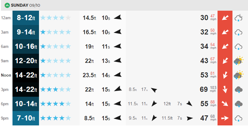 |
| Surf and Wind for Sunday, September 10. |
I thought that was a good illustration of the correlation between the size of the surf under these conditions and the wind direction. Of course the correlation is not perfect. There are other factors to consider, but this is a simple case for illustration purposes.
The north wind, in this case, beside hitting the dunes, will also erode sand from the front of the beach.
When the surf is really high, there won't be much beach that you can detect because of the water.
---
After the 8 AM update, the nhc track has changed very little. Their track is very much like the Euro model that shows the center coming up near the middle of the state. The Euro model has the center passing west of Okeechobee, while the GFS model shows the center passing right over Port St. Lucie. We don't know what will actually happen. The cone still extends from out in the Gulf to out in the Atlantic.
I don't know how many more posts I'll be able to do.
Be safe,
TreasureGuide@comcast.net